About Division : Remote Sensing Applications

           The Division of Remote Sensing Applications (RSA) is established in 1985 as a research division of ICAR-NBSS&LUP for conducting research on the application of remote sensing technologies for an inventory of soil resource, characterization of watersheds, assessment of soil degradation, and ecological studies for land resources management. The division is also carrying out studies to develop innovative techniques of using the latest satellite data in soil characterization and mapping applications.
List of Scientists
Sr.No.NameDesignationDisciplineEmailBiodataPMS
1Dr. G. P. Obi ReddyPrincipal Scientist & HeadGeographyGPO.Reddy@icar.gov.inView BiodataPMS
2Dr. U.SurendranPrincipal ScientistSoil ScienceU.Surendran@icar.gov.inView BiodataPMS
3Dr. Partha Pratim AdhikarySenior ScientistSP&S&WCPartha.Adhikary@icar.gov.inView BiodataPMS
4Dr. Nirmal KumarSenior ScientistAgri.PhysicsNirmal.Kumar3@icar.gov.inView BiodataPMS
5Shri Benukantha DashScientistL&WMEEBenukantha.Dash@icar.gov.inView BiodataPMS
6Shri Sunil B.H.ScientistSoil Sciencesunil.bh@icar.gov.inView BiodataPMS
Infrastructure

The Division of Remote Sensing Applications has the following laboratories:

  • Soil spectral reflectance laboratory with ASD FieldSpec Spectroradiometer.
  • Digital image processing laboratory equipped with RS and GIS software viz. Geomatica, ArcGIS, ERDAS, ENVI, Ecognition, TNTMips, Scanex, and ILWIS.
  • A modest laboratory for analysis of soil physical and chemical parameters.
  • Data Centre is equipped with the latest remote sensing and GIS software viz. ArcGIS Desktop, Arc GIS Server, Geomatica, ERDAS, Ecognition, TNTMips, and Scanex.
  • Cartography unit is furnished with latest remote sensing and GIS software viz. ArcGIS Desktop, Geomatica, Ecognition.
Achievements

Completed Institutional Projects

  1. Prediction of soil fertility parameters through Visible and Near Infrared (VNIR) soil reflectance data of West Bengal

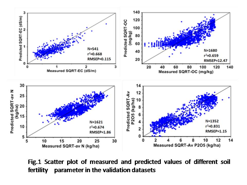
The project was undertaken to investigate the relationship between various soil fertility parameters and soil spectral reflectance data (350 – 2500 nm) and to develop soil reflectance spectral model for prediction of soil fertility parameters.  For this, 3627 surface legacy soil samples collected by Regional Centre, Kolkata from Birbhum, Jalpaiguri and 24 Pargana districts of West Bengal were used. Soil samples were analyzed for pH, OC, available N, P, K, S, Cu, Fe, Mn and Zn using standard methods. Soil reflectance spectra of two thousand five hundred sixty-seven samples (<2 mm size) were recorded using a FieldSpec Pro FR spectroradiometer (Analytical Spectral Devices Inc., Boulder, Colorado) at wavelengths from 350 to 2500 nm with a spectral sampling interval of 1 nm.

The datasets (n= 3627) was divided into two sets viz. calibration and validation sets for developing spectral models for prediction of soil fertility parameters. The approach was to first use cross-validation with all samples in the calibration dataset, and subsequently to test the prediction accuracy using independent validation dataset. Calibrations between soil reflectance and soil parameters were performed using partial least square regression analysis. The best spectral model which resulted in high coefficient of determination of validation (r2), low root mean square error of prediction (RMSEP) and high RPD values was selected. The statistical parameters of the developed spectral models are summarized in table 1. Relatively good calibration models (Fig. 1) have been obtained for EC, OC, available nitrogen, phosphorus (P2O5) and potash (K2O) which showed coefficient of determination (r2) more than 0.60 and RPD values greater than 1.70 in independent validation datasets. This indicates that soil fertility variables viz. EC, OC and available nitrogen, phosphorous and potash can reliably be predicted from soil reflectance data.

  1. Comparative assessment of large-scale mapping through conventional survey and remote sensing techniques – A case study in Parsori watershed, Katol tehsil, Nagpur district, Maharashtra state


The study was undertaken to compare the detailed soil maps prepared following conventional survey and using remote sensing techniques in terms of its accuracy and cost effectiveness. In conventional survey, soil map was prepared based on intensive field traversing and ground truth checking using cadastral map as base. A total of seven soil series were identified and mapped as phases of soil series into 26 mapping units (Fig. 2a). In remote sensing approach, 24 physiogaphic cum photomorphic units were delineated based on visual interpretation of IRS-P6 LISS-IV PAN merged data. A total of 75 pedons were examined for establishing physiography–soil relationship. 5 soil series were identified and mapped as phases of soil series into 12 soil mapping units (Fig. 2b).

For assessing the purity of legend of soil map, methodology suggested by Forbes et al. (1987) was used. Seven soil properties viz. soil depth, colour, texture, drainage, erosion, stoniness, and calcareousness were used for comparison. The soil map prepared by remote sensing technique was tested using 136 observations collected during conventional survey whereas the soil map prepared by conventional survey was tested using field observations collected during survey based on RS technique. Both the maps showed acceptable level of legend purity.

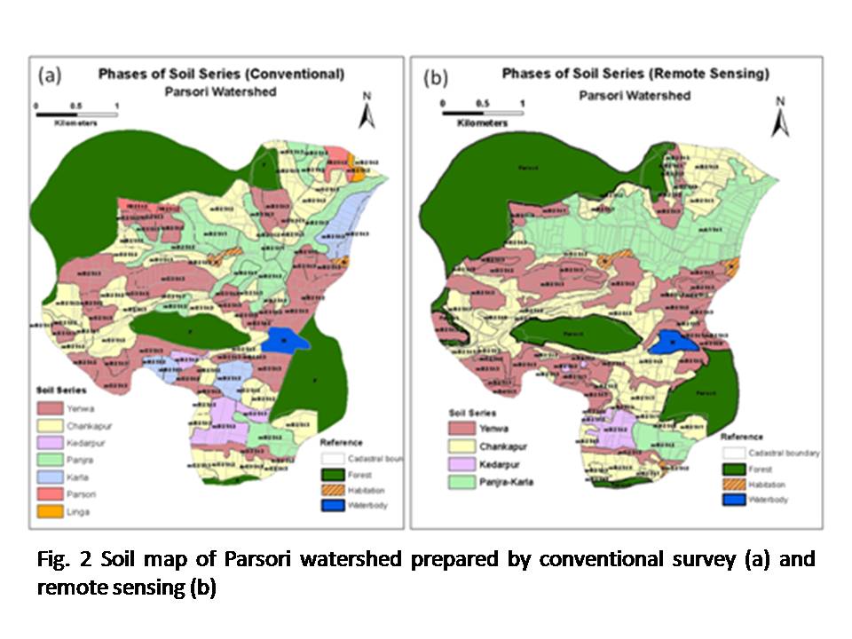
The overall accuracy of soil map was determined using binomial test of accuracy (Rossitter, 2001). The results revealed that the map prepared by remote sensing technique had an accuracy of 59 to 73 percent at 90% probability, whereas, the map prepared by conventional soil survey had an accuracy of 67 to 85% at 90% probability. This indicates that  the map prepared by RS techniques can be considered to be reliable and acceptable. The comparison of cost and time spent in soil mapping by both techniques indicated that there was about 23% saving in cost and 32% in time (no. of days) when remote sensing based soil mapping is done.

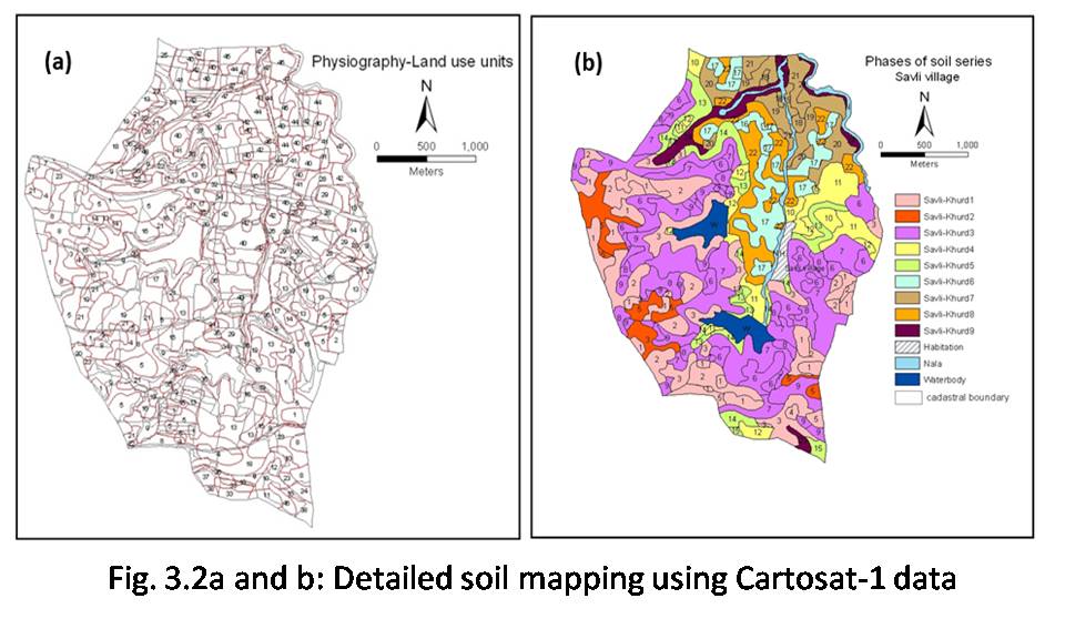
  1. Detailed soil mapping in basaltic terrain for land resources management using Cartosat-1 data (A collaborative project between NBSS&LUP and RRSC-C Nagpur)

The flow chart of methodology for detailed soil mapping using Cartosat-1 data is presented at figure 3.1. As a case study, Savli village of Wardha district was selected to test the methodology of detailed soil mapping using Cartosat-1 data.   DEM was generated from Cartosat-1 stereo pair and contours at 10 m intervel and slope map were prepared. Using DEM and ortho-rectified Cartosat-1 data, anaglyph was generated for 3-D viewing and delineation of major landform units viz. plateau, escarpment, pediment, alluvial plain and narrow valley. The major landforms were further subdivided based on elevation. The pediments were subdivided in to upper and lower pediments and the alluvial plain was divided in to upper and lower alluvial plain.  Land use/land cover map of the area was prepared using Cartosat-1 sharpened IRS-P6 LISS-IV data (November, 2008; January 2010).  Landform, slope and land use/land cover maps have been integrated and 48 PLU (physiography-land use) units were delineated (Fig. 3.2a). Fifty two profiles were studied and soils were grouped into 9 soil series (Fig. 3.2b) and mapped as phases of soil series.  Soils are normally mapped based on landform-soil relation. The accuracy of soil map largely depends on how precisely and accurately the landform units are delineated.  A stereo pair of Cartosat-1 data provides the opportunity for precise and accurate delineation of landform units as it can be used to generate digital elevation model (DEM) for 3-D viewing of the area for delineation of landforms, generation of contours (10m) and deriving information on slope of land. Keeping this in view, the project aimed to study the applicability of high resolution Cartosat-1 data in detailed characterization of land resources and to develop the methodology for its application in detailed soil mapping at 1:10K scale.

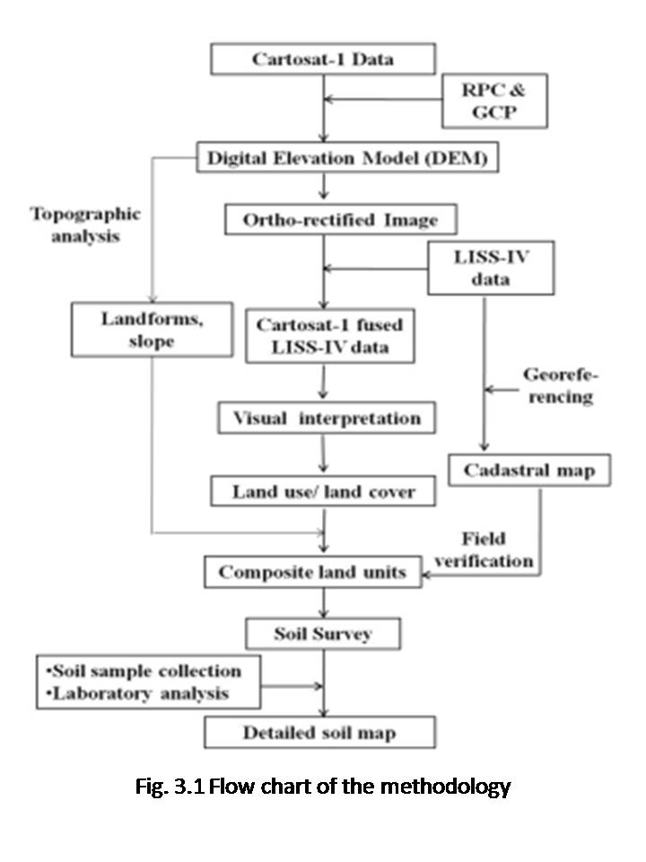
  1. Assessment and mapping of spatial variability of soil properties in basaltic terrain for precision agriculture using VNIR spectroscopy and geo-statistical techniques

The study was undertaken to quantify the spatial variation of soil properties in basaltic terrain using VNIR spectroscopy and geospatial techniques. Nagalvadi micro-watershed (area 460 ha) in Wardha district of Maharashtra was selected in the study and 146 soil samples were collected at a grid interval of 200 by 200 m. Soils were analyzed for physical, hydraulic, chemical and fertility parameters and statistical analysis was done. Spectral reflectance characteristics (350- 2500 nm) of soil samples collected were studied using ASD spectroradiometer.

Soil spatial variability was quantified through semivariogram analysis and the maps were prepared through ordinary kriging. Spherical model fits well with experimental semivariogram of sand, pH, OC, CEC, moisture retention at -33 and -1500 kPa, available P, K, Fe and Cu, whereas, Gaussian model was found to be the best fit for silt, clay, available N, Mn and Zn. The kriged maps indicated that the available N, P and K was low, very low to low and low to very high, respectively (Fig. 4 a to c). DTPA-extractable micronutrients indicated that available Fe, Mn and Cu was adequate, whereas, available Zn was found deficient in the study area. The kriged maps combined with cadastral maps provides site-specific spatial variation in soil characteristics and soil nutrient availability to improve the nutrient use efficiency of applied nutrients and yields at farm level.

For developing spectral models for prediction of soil properties, all the datasets were randomly divided in to two sets viz. calibration and validation datasets. Each soil property of the calibration datasets was calibrated with soil reflectance data using PLSR (Partial Least Square Regression) technique to identify the best possible spectral models for prediction of soil properties. Coefficient of determination (r2) values of different spectral models of soil properties ranged between 0.52 and 0.80. Spectral models obtained for those soil properties for which coefficient of regression were less than 0.5 were rejected and dropped from further testing. The spectral models were applied on validation data to test the suitability of the model. Relatively good spectral models were obtained for sand (r2: 0.79) clay (r2: 0.60), moisture retention at 33 kPa (r2: 0.68), moisture retention at 1500 kPa (r2: 0.66), pH (r2: 0.77), OC (r2: 0.66), available Fe (r2: 0.73), available Mn (r2: 0.66), available Cu (r2: 0.66) and available Zn (r2: 0.71).

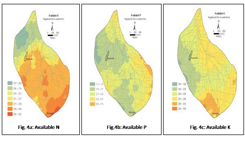
  1. Integrated use of remote sensing and field data for assessing soil quality under rainfed conditions in Parsori watershed, Katol tehsil, Nagpur district, Maharashtra


In this study, the concept of a vegetation index namely Sustainable Vegetation Index (SVI) on the lines of Sustainable Yield Index is proposed; as an alternative measure of soil quality for biomass production and also as a dependent variable for identifying the minimum dataset required to estimate soil quality index. Cartosat-1 DEM of 10 m resolution was used to derive primary (slope, aspect, hillshade, curvature etc.) and secondary (topographical wetness index, stream power index etc.) terrain attributes. The minimum dataset (MDS) is identified through Pearson correlation matrix of soil and terrain variables in respect of SVI using 2-tailed significance test (P ≤0.05) as a threshold for selection in each LUT. Land use/land cover map of the Parsori watershed was prepared through visual analysis of IRS-P6 LISS-IV data. Sustainable vegetation index (SVI) for different land use/land cover classes were calculated (Fig 5a,b,c). SVI is categorized as poor, moderate, good and very good  based on the threshold values defined as <40, 40-60, 60-80, ≥80% of the maximum SVI in the corresponding agricultural land use, respectively.

MDS identified under single crop, double crop and orchard lands comprise of 2 (elevation and organic carbon), 5 (elevation, sediment transport index, organic carbon, clay and moisture retention at field capacity) and 4 (elevation, aspect, CaCO3 and depth) parameters, respectively. Among soil variables, soil depth, clay, CaCO3 content and -33Kpa soil moisture showed good correlation with SVI. Topo-transfer functions were developed for prediction of organic carbon, clay and soil depth from terrain parameters.

Organic Carbon (%) = 5.917 – (0.029 * Hillshade) – (0.038 *Slope) ………Eq.1

Clay (%) = 137.371 + (2.27 * TWI) – (0.058 * Aspect) – (0.206 * Elevation) ……eq.2

Soil depth (cm) = 849.96 – (1.695 * Elevation) – (855.233 * Plan curvature)  …….Eq.3.

The calibration statistics in terms of R2, AMRE (Absolute Mean Relative Error), RMSE (Root of the Mean Square Error), NRMSE (Normalized RMSE), SE (Standard Error of Mean) revealed good calibration having values as 0.75, 0.15, 0.12, 0.18, and 0.03 for OC;  0.83, 0.08, 4.69, 0.09 and 1.53 for clay; and  0.81, 0.42, 15.57, 0.32 and 4.86 for depth, respectively. Validation statistics of the models i.e. R2 (0.80, 0.80 and 0.84), AMRE (0.12, 0.08 and 0.30), RMSE (0.10, 4.95 and 18.35), NRMSE (0.13, 0.10 and 0.25) and SE (0.05, 2.50 and 9.69) also indicate an efficient prediction of OC, clay and depth, respectively.

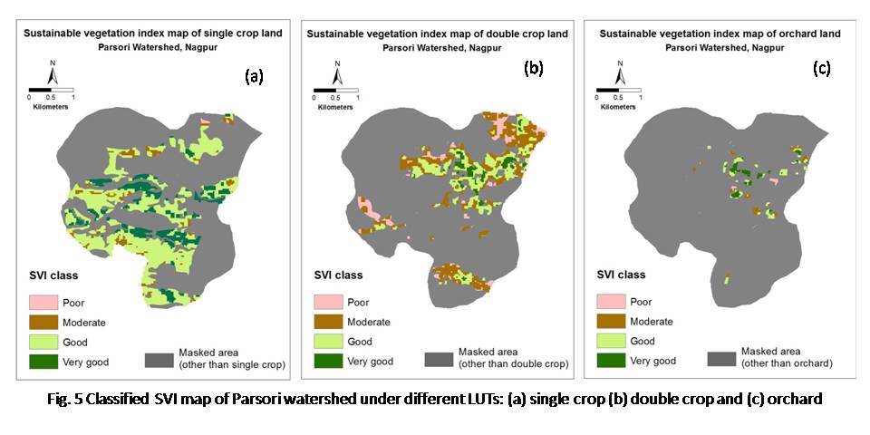
  1. Digital soil mapping using digital terrain analysis and multispectral remote sensing data – A pilot study in Tendulwani watershed of Nagpur district, Maharashtra


The project is aimed at exploring the possibility of using remote sensing and GIS technologies for developing digital soil maps in order to provide an alternative to conventional soil survey and mapping methods through increased automation using geo-informatics. Soils are generally mapped based on landform-soil relation. A stereo pair of Cartosat-1 data provides the scope of precise and accurate delineation of landform units. To test the methodology, Tendulwani watershed, Nagpur was selected for the pilot study. Cartosat-1 was ortho-rectified and DEM was generated and smoothened. Derivation of primary (Slope, aspect, hill shade, curvature, drainage etc.) and secondary (Topographical wetness index (TWI), Stream power index (SPI), etc.) terrain attributes were accomplished based on digital terrain analysis.

            Digital landform analysis model has been developed through object based analysis of major terrain attributes (elevation, slope, contour and profile curvature) along with other remote sensing data products (NDVI). Digital landform map shows the major landform units viz. plateau, isolated hillocks, escarpment, pediment, upper and lower alluvial plain and channels occupy 28, 1, 8, 35, 17, 4 and 6% of the total geographical area (TGA = 1080.3 ha) of the watershed, respectively. Further, digital land use/land cover analysis was achieved using cadastral map along with NDVI and LISS-IV band information. Land use/land cover map of the watershed reveals maximum area under forest (34.1%) followed by single crop (26.9%); whereas wasteland and double crop share 23.2 and 9.6% of TGA respectively.  The landform, slope and land use/land cover maps were integrated in GIS and a composite map show 35 physiography-land use (PLU) units.

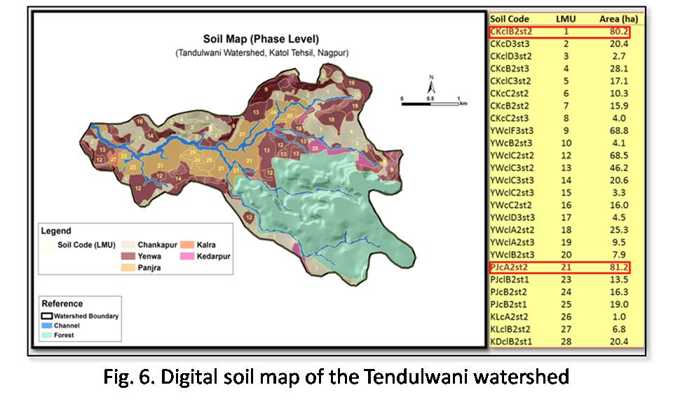
The LEU-soil relationship developed from the legacy data of Parsori watershed (neighboring watershed) through expert based method was applied on the Tendulwani watershed to generate the digital soil map (Fig. 6). The digital soil map of the watershed is having 5 soil series and 26 phases.Landscape ecological unit (LEU) map was generated by integrating the landform (derived using object based image analysis approach), slope (from analysis of Cartosat-1 DEM) and land use layers (Image analysis of Cartosat-LISS-IV data). A total 33 units of LEUs were obtained in the watershed. The uniform LEU schema composed of capital letters (Landform), followed by numeric character (slope class) and small letter (land use) is developed.

7.      Digital terrain modeling for object based automatic delineation and classification of landforms in Katol tehsil, Nagpur district using high resolution Cartosat DEM and IRS P-6 LISS IV data

The project was aimed to generate automatic delineation of landforms using object based image segmentation and to classify the digital landforms using suitable classification algorithms. In the project ortho-rectified Cartosat DEM (2.5m) and IRS P6 LISS-IV Mx datasets were used to generate various digital terrain variables in GIS format. Various primary (slope, aspect, curvature, contour etc.) and secondary terrain variables (topographic wetness index, topographic position index and topographic roughness index) have been generated for the tehsil using Cartosat-1 DEM. Seamless DEM (10 m) and ortho images for the Katol tehsil from Cartosat–1 Stereo-pairs has been generated. Decision rules have been developed in eCognition software for automated delineation of landforms using object based image analysis techniques from the terrain and land use parameters generated from Cartosat DEM (10 m) and LISS IV images. Various primary (slope, aspect, curvature, contour etc.) and secondary terrain variables (topographic wetness index, topographic position index and topographic roughness index) have been generated for the tehsil using Cartosat-1 DEM. The landform classification system was followed based on the neighborhood relationships and topological functions. This work demonstrates the capabilities of multi-scale image segmentation/object relationship modeling methodology in GIS for terrain classification and automatic landform mapping. GPS based field survey data collected on landscape, landforms, slope and land use/land cover for 50 locations were used to validate the delineated landforms in the tehsil. The landform of part of Katol tehsil delineated based on the object based automatic delineation and classification algorithm is shown in figure 7.

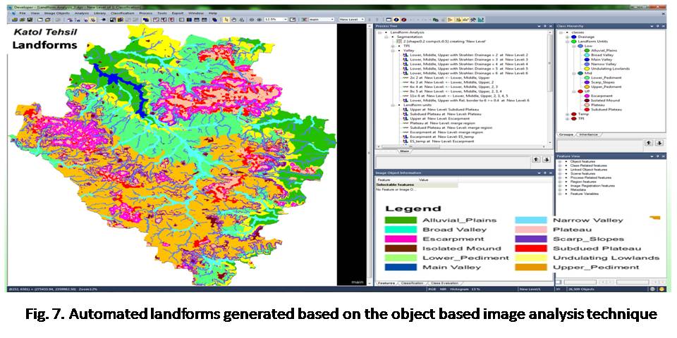
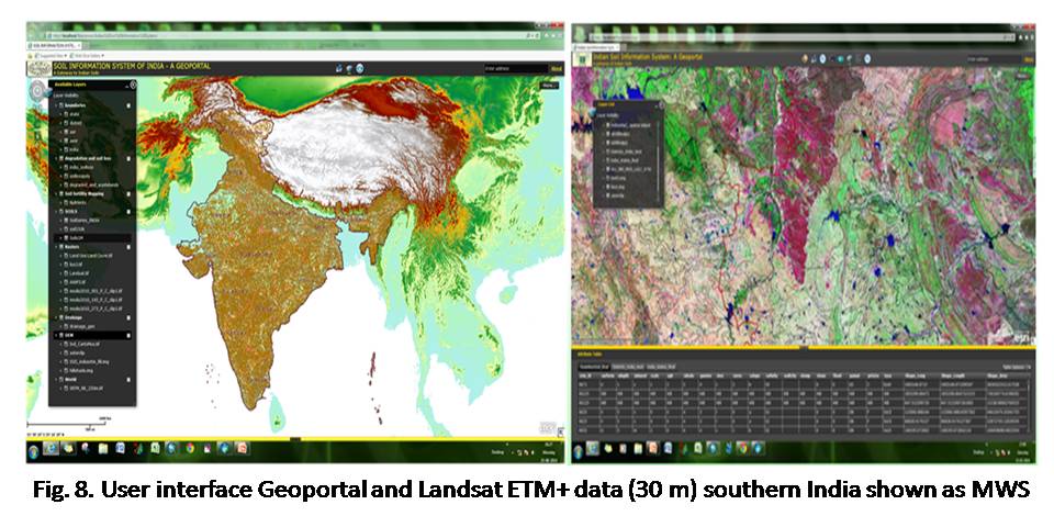
8. Development of Indian Soil Information System – A GeoPortal

Initially, the need analysis was carried out to understand the available data formats, data gaps and source of datasets to develop robust soil information system and develop prototype Geoportal. The data input schema was developed and available soil resources and allied data were reengineered to develop soil information system. In compilation of spatial datasets, different data formats were brought into a single generic model. Soils data on 1:1m, 1:250,000 and 1:50,000 scales for the selected districts, soil loss, degraded and wastelands data, AWiFs data (58m), IRS-P6 LISS-III (23.5m), satellite data, SRTM (90m), ASTER (30m), GDEM, were brought under soil information system. The seamless mosaic of satellite database for India was developed by using about 370 scenes of IRS-P6 LISS-III satellite data. To develop digital elevation models of India at 30m resolution, 375 scenes of Cartosat and 400 scenes of ASTER GDEM, respectively have been used. The climatic database for India has been generated using the available climatic data for 1600 stations. The 10 km grid point data at state level for about 19,000 grid points have been compiled.

The protype Geoportal with Web Map Services (WMS), Web Catalogue Services (WCS), interface tools and minimum Geoportal functionalities have been developed. In the developed prototype Geoportal various thematic map services have been deployed as WMS services with uniform projection standards. A thematic web service allows users to specify a link to the data source, enabling users to produce thematic maps. The Catalogue Service component provides the underlying database and data management capabilities that enable users to post and discover metadata records. Data and data services were catalogued systematically according to a metadata standards and schema designated for Geoportal. Geoportal provide an easy-to-use interface for users to visualize and access resources registered with the Geoportal to use in their own projects. The web mapping applications were created using the ArcGIS Viewer for Flex plugin. The map package was then published to the server hosting the web mapping services. After the necessary tools were added, the prototype Geoportal has been structured and configured in the local host. The user interface of developed prototype Geoportal and Landsat ETM+ data of India as WMS are shown in fig 8.

9. Development of District Soil Information System on 1:50,000 Scale (50 Districts)

The core objective of the project was to develop District Soil Information System (DSIS) for 50 districts on 1:50,000 scale with uniform standards to store, query, update and manage the district level soils database. In the project, the standardized protocols and procedures have been developed to organize the district level soils data in GIS. The standardized and enriched district soil information system has been developed for 50 districts to query, update and retrieve soils and associated database at district level for the users. The soil database for 50 districts, which includes Jorhat, Kamroop, Morigaon, North Tripura, Sibsagar, South Tripura  and West Tripura District (North-East region), Bastar, Bhandara, Chandrapur, Gondia, Raisen, Seoni, Wardha and Yavatmal District (Central region), Bellary, Chitradurga, Hassan, Kolar, Medak, Mysore, Tumkur, North Goa, South Goa and Mallampuram District (Southern region), Ajmer, Banswara, Bhilwara, Bundi (Western region), Arungabad, Bankura, Bardhaman, Birbhum, East Sikkim, Hugli, Kooch Bihar, Madhubani, North Sikkim, Puri, Purulia, Ranchi, Sambalpur, South Sikkim and West Sikkim District (Eastern region), and Delhi, Fatehgarh Sahib, Hoshiarpur, Moradabad, Mujaffarnagar, Nawashahar and Patiala District (Northern region) districts have been digitized and brought under DSIS.

The available databases on soil loss, degraded/wastelands, climate and AER and AESR have been harmonized with districts soils database. The terrain database on SRTM DEM (90m) and ASTER DEM (30m) as well as two dates (kharif and rabi) of Landsat ETM+ (30m) data at district level was also developed to understand the soil–terrain-land use/land cover relationship. About 30 terrain and soil based thematic maps have been generated for each district. The digital elevation, satellite data, soil resource database and soil based thematic databases have been integrated with Indian Soil Information System and Geoportal. DSIS ensures data standardization, easy maintenance and updation and query district level soil databases. The district soil information system has been brought under proto-type Geoportal, it helps to systematically search, access, visualize and update soils and allied data. District Soil Information System developed for 50 districts and soils of Hassan district in GeoPDF format are shown in figure 9.
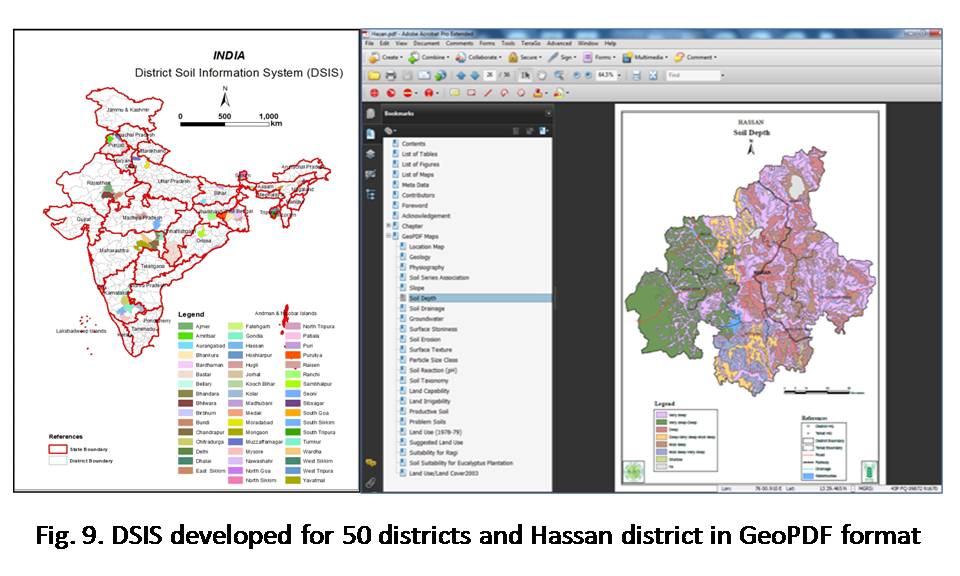
10.GIS Modeling to Predict Land Productivity Potential (LPP) for Major Crops in Wardha District of Sub-Humid (Dry) Region, Eastern Maharashtra

The project aimed to assess terrain, climate, and soil resource databases to delineate and characterize Pedo-Ecological Units (PEU), delineate and characterize cropping systems using temporal satellite data and field information, in order to develop a suitable model in GIS environment to integrate the thematic parameters in mapping crop based Land Productivity Potential (LPP) and validate with randomly selected field observations of crop yields. During the reporting period, terrain information (elevation, slope and aspect) were incorporated to improve the accuracy of the land use land cover classification of IRS P6-LISS III data for Wardha district. Pedo-Ecological Units and major cropping systems of the district were derived using MODIS 16 days composite NDVI time series data for year 2010. Land capability classification of the district has been revised. Data mining algorithms were applied for machine learning of land capability classification through soil attributes. Pedo-ecological units of the Wardha district were delineated by integrating terrain parameters (slope and topographic wetness index), rainfall data, cropping system and soil parameters (AWC, erosion, soil depth, permeability, texture, and drainage) on 1:50 scale.

Six distinct pedo-ecological units were identified ranging from extremely poor to very good in crop production point of view. The very poor and poor PEUs are associated with moderately steep to steep slopes, shallow soil depth, excessive drainage and coarse texture soils. Whereas, the good and very good PEU’s are associated with nearly level to level slopes, deep to very deep soils, well drained and clayey texture soils. Land productivity potential for Soybean, Cotton and Wheat crops were generated based on integration of principle components of 4 years MODIS NDVI 16 days composites, Terrain parameters (slope, topographic wetness index), and soil attributes (soil depth, drainage, erosion, pH and texture) using weighted overlay analysis technique in GIS. Land productivity potentials of the crops were validated with the help of GPS based collected field data on productivity. Pedo-Ecological Units, major cropping systems, land productivity potential for soybean and cotton are shown in figure 10.

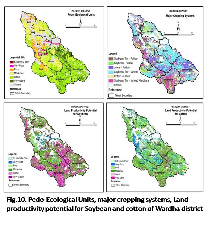
11.Assessment of spatio-temporal variability of major crops in different states of India for land use planning: A GIS based approach

This research project was undertaken to analyse the temporal changes in land use during the last sixty years and the trend of crop diversification that has taken place in Indian Agriculture. In the project an attempt has been made to analyse the extent of change in area under important major crops of India and to develop the spatial area database of major crops in GIS considering district as a unit. The salient findings of the study show that with the increasing population trend of India, the per capita availability of land, forests and arable lands were decreasing. The proportion of area under forests and other uncultivable land were almost consistent in respect to total reported area on different points of time. To feed the growing population, it is of paramount importance to bring the culturable waste land and fallow land under crop cultivation to boost agricultural production.

With the modernization of agriculture and self-sufficiency in food production, the area shift that has taken place towards cereals in the immediate aftermath of Green Revolution, has started moving in the opposite direction, i.e. from cereals to non-cereals. Since the recent trend in inter-crop area shifts has its origin in the price and trade in inter-crop area shifts has its origin in the price and trade policy changes of the 1980’s they indicate the increasing market influence on the area allocation. The area under horticulture crops increased three times in last six decades. The agricultural land resources in the country have been shrinking, the per capita availability of arable land is expected to be less than 0.1 hectare during the next decade. Therefore, future increases in total production must accurred through the increase in per hectare productivity. This will necessitate the development of high yielding varieties, efficient management practices, enhanced cropping intensity and sustainable use of natural resources. The problems of future growth will thus be much more complex; hence, seeking a comprehensive solution must be based on interdisciplinary research and technology development. Spatio-temporal changes of rice and wheat cultivation in India during the year 1975-76 to 2009-10 are shown in figure 11.

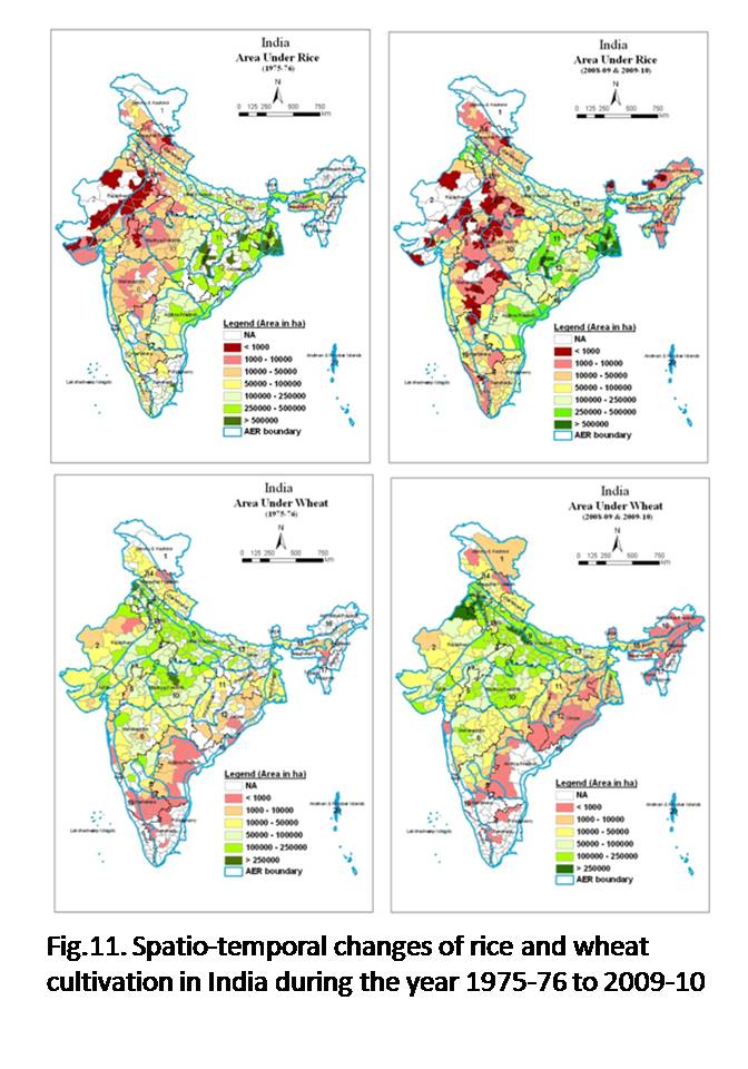
12. Development of web based GIS system for real-time field data collection, transfer, storing and retrieval

The core objective of the project was to develop web based GIS system for real-time field data collection, transfer, storage and retrieval. In the project, the formats, protocols and GPS based field data collection devices have been developed to acquire, store, display and transmit georeferenced soil-site characteristics data including geo-tagged profile and site photographs taken during field visits. The system encompasses advanced mobile, wireless and Internet computing technologies that together facilitate the sharing of field data between the study site and remote locations in real-time. An android based field data collection system and applications have been developed for data entry, photograph collection, storage and transfer. Proformas have been developed in drop down to enter the field data for various parameters in order to minimize the human error.

The device having 5 mega pixel camera and inbuilt GPS removes the need of separate GPS and camera in the surveyors’ kit. The 32 GB storage capacity of the device can store the entries in absence of internet signal, which may be sent to the server. A separate web based system has also been developed for individual user and for administrators at different levels for monitoring and generation of report. Provisions for entry of laboratory data of soil physical and chemical properties have also been made to integrate database. Thus the developed system provides systematic data collection and real-time transfer to central server, less manual error, accurate GPS location with altitude and Date & Time from Satellite, geo-tagged photographs, three level data security, instant generation of report, live monitoring of work progress from anywhere and centralized data repository. The developed web based GPS based real-time field data collection device and applications have immense help in field data collection, transfer, storing and retrieval in systematic way. Developed GPS based field data collection device and its application are shown in figure 12.

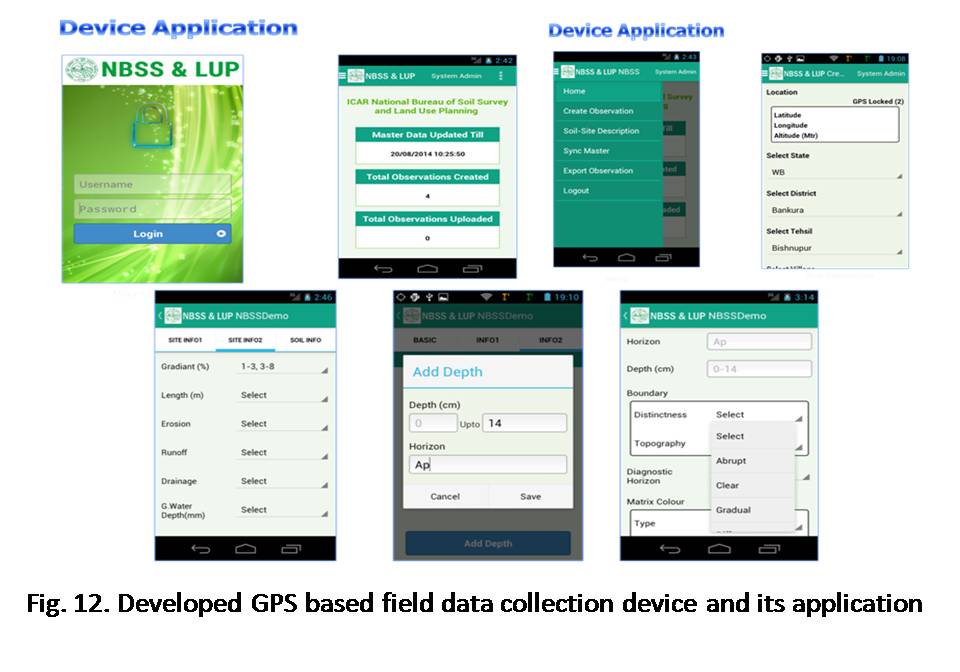
13.Land resource inventory for integrated agriculture planning of Miniwada Panchayat, Katol tehsil, Nagpur using high resolution satellite data and GIS

The study was aimed to inventorize and characterize land resources to assess spatio-temporal cropland dynamics, design and develop geo-spatial database and to integrate the biophysical and socio-economic parameters for suitability of crops at village level using high resolution satellite data LISS-IV and Cartosat-1DEM considering biophysical and socio-economic parameters as a base.

Seamless DEM of 10 m resolution was generated from seven Cartosat-1 stereo pairs using Intergraph LPS. Ortho-rectified images of Cartosat-1 were also generated. The Resourcesat-2 LISS IV images and ortho-rectified Cartosat-1 data were fused to get PAN sharpened data for the panchayat. Base maps were generated with DEM (10 m) extracted from Cartosat-1 stereo pairs and Resourcesat-2 LISS IV images. Manual and automated landforms for Miniwada panchayat were delineated from the Cartosat DEM (10 m) and LISS IV images. Base maps were finalized and preliminary survey of the panchayat was carried out. GPS based points on landscape, landforms, slope and land use/land cover covering different landforms were collected in the panchayat to validate the landforms. Land resource inventory for the three villages in Miniwada Panchayat has been carried out from 22 February to 7 March, 2014. Landform-soil units were identified while traversing the area. 249 surface soil samples at 250m grid interval have been studied and collected for analysis. Total 60 profiles have been studied and soil samples were collected in the study area covering 1621 ha. A total of 23 phases have been identified, seven phases in Mw-1, four phases in Mw-2, two phases in Mw-3, four phases in Mw-4, two phases in Mw-5 and four phases in Mw-6. Resourcesat 2 LISS IV, Cartosat DEM (10m), Grid points, Landforms, physiography-landform units and soils of Miniwada Panchayat, Katol tehsil, Nagpur district are shown in figure 13.

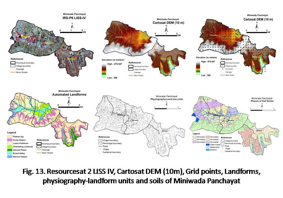
14.Development of digital terrain database and landform mapping at Tehsil/Block level in different agro-ecological sub-regions of Central India using Geospatial techniques

The project was planned to develop digital terrain database and landform mapping for nine blocks in different agro-ecological sub-regions of central India using geospatial techniques. IRS-P6 P6 LISS-IV (5.8 m) satellite data and SRTM DEM (30 m) digital terrain database has been generated for the selected nine blocks namely Darwha, Rahuri and Parbhani in Maharashtra, Bemetara and Jagdalpur in Chhattisgarh, Dhanora, Raisen, Tikamgarh and Jagdalpur in Madhaya Pradesh states. Slope analysis has been carried out using SRTM-DEM (30m) for all the selected blocks. The detail land use/land cover analysis has been carried out using IRS-P6 P6 LISS-IV data for the selected blocks. Landform analysis was carried out based on the visual interpretation of high resolution IRS-P6 P6 LISS-IV data in conjunction with DEM. Digital terrain analysis and landform mapping has been carried for selected nine blocks. The landforms have been further sub-divided as landscape ecological units based on slope and land use/land cover data.

The analysis shows that eleven distinct landforms and 47 LEU’s have been identified in Jagdalpur block of Jagdalpur district, Chhattisgarh. Nine distinct landforms and 53 LEU’s have been identified in Tikamgarh block, Tikamgarh district, Madhya Pradesh. Thirteen distinct landforms and 48 LEU’s have been identified in Parbhani block, Parbhani district, Maharashtra.  Nine distinct landforms and 54 LEU’s have been identified in Rahuri block, Ahmednagar district, Maharashtra. Ten distinct landforms and 63 LEU’s have been identified in Raisen block, Raisen district, Madhya Pradesh. Ten distinct landforms and 42 LEU’s have been identified in Bemetra block, Durg district, Chhattisgarh.  Ten distinct landforms and 42 LEU’s have been identified in Bemetra block, Durg district, Chhattisgarh Datia block, Datia district, Madhya Pradesh. Nine distinct landforms and 47 LEU’s have been identified in Datia block, Datia district, Madhya Pradesh. Eight distinct landforms and 80 LEU’s have been identified in Darwha block, Yavatmal district, Maharashtra. Ten distinct landforms and 63 LEU’s have been identified in Dhanora block, Seoni district, Madhya Pradesh. Nine distinct landforms and 53 LEU’s have been identified in Tikamgargh block, Madhaya Pardesh. IRS-P6 LISS-IV data and LEU’s of Parbhani block is shown figure 14.

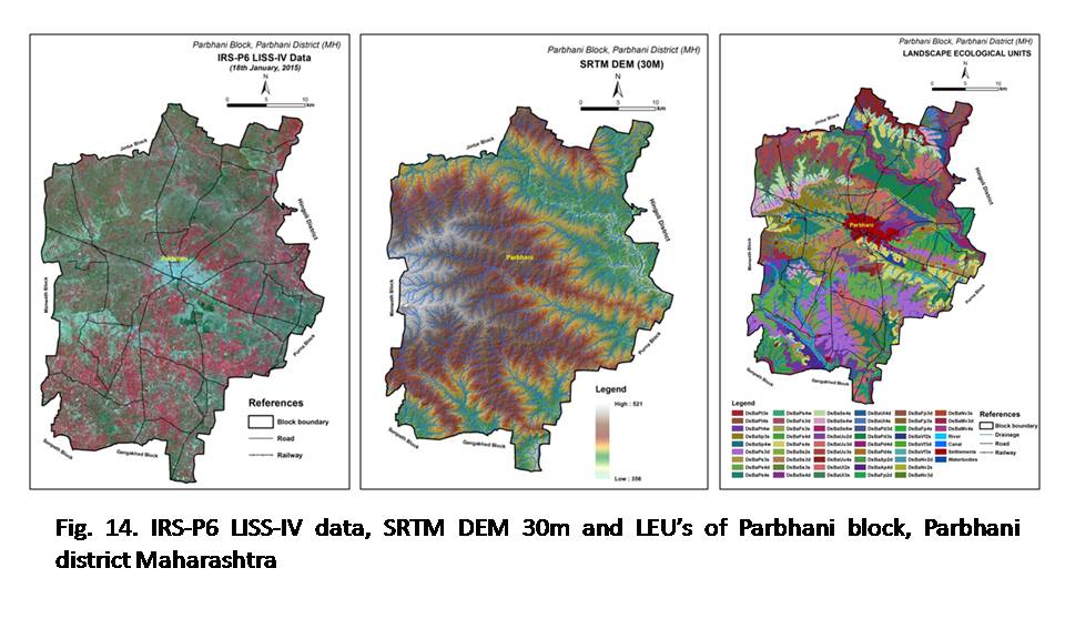
Design and Development of Land Resource Information System and NBSS Geoportal for Geospatial Database Management and Dissemination

The project was aimed to design and development of land resource information system of India and NBSS Geoportal for geospatial database management and dissemination. In the project, the necessary software and hardware application server infrastructure for Geoportal development has been created. The user interface of NBSS Geo-portal (BHOOMI) has been redesigned and developed to visualize various thematic layers and services. The schema for various vector, raster and point database has been standardized to deploy various soil attribute database. The point layer data on benchmark soil information of India for 64 sites, State wise soil series of India for 15 states, soil series databse for 22 districts, Grid point data for 752 sites collected under NATP project on soil physical and chemical properties database, nutrient database for north-eastern states, soil fertility status in rubber growing areas of Kerala has been processed and deployed in BHOOMI Geoportal. Major physiographic units of India, sub physiographic units of India, Agro ecological regions of India (2015), Agro ecological sub regions of India, Agro ecological units of Kerala, Soil loss of India, various soil based thematic layers on 1:1m scale, degraded and wastelands of India, soil loss thematic layer of India, soil based thematic layers for 20 districts on 1:50,000 scale, various terrain and soil based thematic layers at block level for 30 blocks have been processed and deployed in BHOOMI Geoportal.

Data services were systematically catalogued according to a metadata standards and schema designated for Geoportal. Soils data on 1:1m and 1:250,000 scale soil loss, degraded and wastelands data, AWiFs data (58m), IRS-P6 LISS-III (23.5m), satellite data, SRTM (90m), ASTER (30m), GDEM, were deployed. Using application server tools, the Geoportal with Web Map Services (WMS), Web Catalogue Services (WCS), interface tools and minimum Geoportal functionalities have been developed.Under land use planning section, major Crop growing areas, crop core growing areas, land management units, crop base land management units, area and spread for 17 crops at state level, land degradation status in irrigated and rainfed areas and SRTM DEM (30m) for India has been processed and deployed in BHOOMI Geoportal.

Completed Externally Funded projects

15.Development of soil reflectance methods and low cost sensors for variable rate inputs in precision farming (NAIP-Component 4)

The NAIP supported project was undertaken in collaboration with PAU, Ludhiana, CSSRI, Karnal and PRS, Ludhiana to study the relationship between soil characteristics of the Indo-Gangetic Plains and laboratory measured soil reflectance data between 350- 2500 nm and to develop spectral models for prediction of soil properties from soil reflectance data. A total of 4745 surface soil samples were collected from four districts viz. Gurdaspur, Bhatinda, Moga and Ludhiana of Punjab state representing normal soils and three districts viz. Sonipat, Rohtak and Panipat of Haryana representing salt-affected soils during 2009 to 2011 after harvesting of rice and wheat crops. Soil clusters of Punjab, in general, had loamy sand through silty clay loam to clay texture, neutral to slightly alkaline in reaction, were non-saline (EC <1.5 dSm-1) with low organic carbon (<0.5%), low to medium available K and high to very high available P.  On the contrary, the soil clusters of Haryana had very low to medium organic carbon (0.02 to 0.8%), and were mostly salt-affected with electrical conductivity (ECe) of soils varying from 0.16 to 177 dSm-1.

The visible near-infrared (VNIR) spectral reflectance characteristics of soils were studied under laboratory conditions between 350-2500 nm using ASD spectroradiometer. The reflectance spectra of soils, in general, showed prominent absorption features around 1400, 1900 and 2200 nm. Calibrations of soil reflectance data with organic carbon (SOC) and available K of Punjab soils and different soil salinity parameters of Haryana were performed using partial least square regression analysis. The application of calibration model on validation datasets (Fig. 15) resulted in very good prediction of soil organic carbon (r2= 0.81, RMSEP=0.116, RPD=2.30) and available K (r2=0.78, RMSEP=0.243, RPD=2.13), ECe (r2=0.94, RMSE=5.33, RPD=3.99), saturation extract Ca2++Mg2+ (r2=0.81, RMSE=1.51, RPD=2.40), saturation extract Na+ (r2=0.88, RMSE=2.45, RPD=2.89), saturation extract Cl (r2= 0.92, RMSE= 2.16, RPD=3.44), saturation extract SO42- (r2= 0.67, RMSE= 2.21, RPD=1.60) and CaCO3 (r2= 0.66, RMSE= 0.79, RPD=1.72).From this study, it can be concluded that VNIR spectroscopy can be used with reliable accuracy for rapid prediction of SOC, available K, and soil salinity parameters viz. ECe, saturated extract Na+, Ca2+ + Mg2+ and Cl in the soils of the Indo-Gangetic Plains of Punjab and Haryana. The hyperspectral models developed could assist in real-time monitoring of soil organic carbon and salinity parameters in the IGP region for sustainable management.

16.Mapping and assessment of land degradation in major ecosystems of India using geospatial technologies (ICAR funded extramural project)


In this project, ten blocks namely Fatehgarh (Jaiselmer) and Bukkarayyasamudram (Anantapur) in arid ecosystem, Jagner (Agra) and Kangeyam (Tirupur) in semi-arid ecosystem, Nagrota Bagwan and Dhanpatganj (Sultanpur) in humid ecosystem, Mangan (East Sikkim) and Umsning (Ri-bhoi) in per-humid ecosystem and Ganjam and Tiswadi (North Goa) in Coastal ecosystem were selected with the objectives to develop a robust methodology for mapping and assessment of kind and severity of land degradation at 1:10K using high resolution temporal satellite data, legacy and field survey data, developed LDI and LDIS in GIS for the selected blocks. The temporal satellite of Landsat ETM+, OLI and Sentinel 2 for kharif, rabi & zaid seasons for the year 2000-01 and 2015-16 were used for mapping and assessment of land degradation. SRTM DEM (30m) data has been used to derive various terrain parameters at block level. The temporal satellite has been analyzed to develop landforms maps for Fatehgarh (Rajasthan) and Dhanpatganj (UP), blocks and they were used to conduct soil survey under LRI on 1:10K to assess land degradation.

The methodology was developed for mapping and assessment of type and severity of land degradation at 1:10K in selected blocks of major ecosystems using high resolution temporal satellite data, legacy and field survey data. The legend schema for major land degradation categories and sub-classes have been developed to map and assess the land degradation at block level. Revised Universal Soil Loss Equation (RUSLE) has been used to compute the soil loss at block level. R-factor has been computed using thirty years rainfall data for the selected blocks. The soil survey data collected under LRI project has been used to compute the K-factor in GIS. SRTM DEM (30m) data has been used to compute LS-factor. Using Landsat-8 (OLI) data land use systems information has been for the year 2015-16 for selected blocks and C & P factors have been computed using the land use systems, slope and conservation practices. Soil loss has been assessed for the selected blocks using RUSLE in GIS. The land degradation in Fatehgarh (Jaiselmer) has been assessed using the interpretation of temporal satellite data. Field survey and verification has been completed in the blocks and collected GPS based information on terrain, landforms and land use systems, land degradation processes and necessary field photographs to assess and validate various land degradation processes at block level. By integrating soil loss, acidic soils, salt affected soils and other degradation categories, the land degradation status for selected blocks has been generated. The LDI and LDIS in GIS have been developed for the selected blocks. Landsat ETM+ PAN fused 15m data, R,K, LS and C-factors and soil loss map of Umsining block (Ri-bhoi district) in per-humid ecosystem of Meghalaya state are shown in figure 16.

17.Capacity Building in the Area of Remote Sensing & GIS Applications in Natural Resources Management (ISRO and NBSS&LUP Collaborative programme)

This collaborative project of ISRO (NNRMS) and NBSS&LUP was taken up on ‘Capacity Building in the Area of RS & GIS Applications in Natural Resources Management’ with the objectives of capacity building in the advanced fields of RS&GIS applications in natural resources management as a joint effort of NBSS&LUP and ISRO. It was also aimed to up-scale the skills of manpower to cater to the needs of national, regional and district level developmental agencies. In this project, it was envisaged to impart practical knowledge in the fields of remote sensing and GIS. The trained personnel would be able to use these state-of-the-art technologies in their operated fields at local level. The technological expertise imparted to different client of state and other agencies. This would help to contribute to the national level developmental planning. Personnels undergoing this training will get an exposure on the potentials of remote sensing and & GIS applications in natural resource management at their respective institutes. In this project conducted 7 training programmes (Table 1) of 21 days duration each during 2012-2013 & 2013-2014. 153 participants from ICAR, SAU’s, State Departments and KVK’s were trained at NBSS&LUP Hqrts and at its Regional Centres during 2012-14.

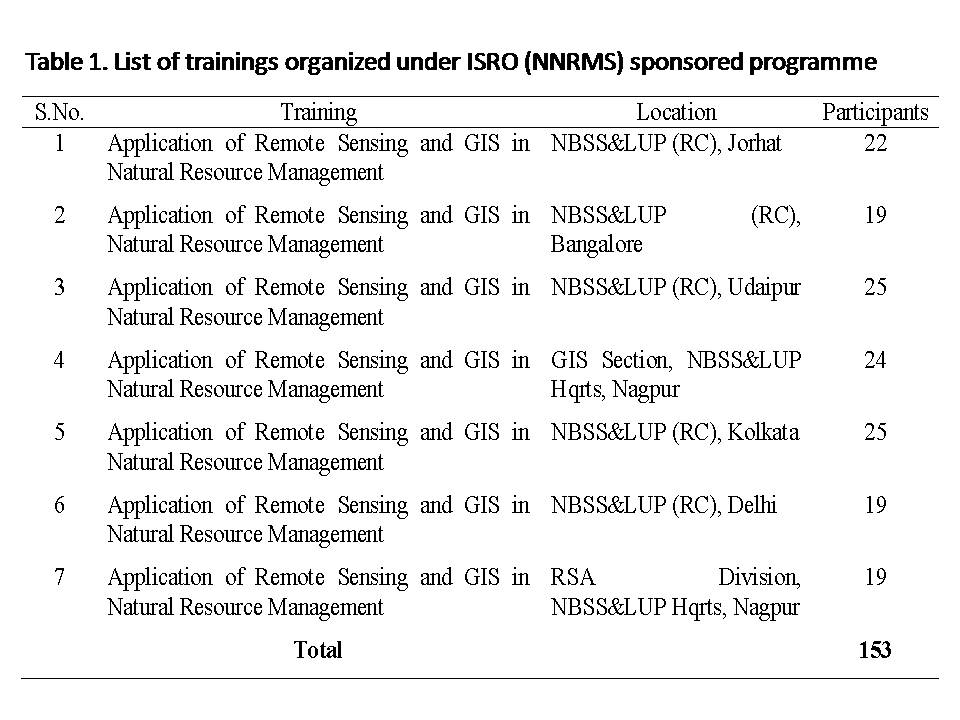
18. Strengthening of Digital Library and Information Management under NARS (e-Granth) NAIP (C-I)

In this project, 217 records of collection of old rare books, old journals, reports and various documents were digitized. Records of 6500 books, 3200 journals, 100 theses and 170 NBSS&LUP publications were converted. Data was exported from SOUL software in excel format. Nearly record of 6500 books, 3200 journals, 100 theses and 170 NBSS&LUP publications were converted from excel to MARC 21. In addition to acquisition of conventional literature like books, scientific/technical journals, an effort was made to trace and acquire all non-conventional literatures such as annual reports, soil survey reports and agricultural statistical data pertaining to all states. Koha has been successfully implemented in NBSS&LUP Library. Union catalogue was prepared for each centre of NBSS&LUP to obtain the information on a common platform. Manually all records of documents available in the library were checked. ISBN of all books were entered in the excel format.

Open source software, Koha: Integrated Library Management System was successfully installed. Koha was installed on Debian Wheezy 7.1 operating system. It has been successfully implemented in NBSS&LUP Library. All records of books and journals were imported into Koha software. It provides a full-functioned Online Public Access Catalog (OPAC). Koha is open source software and fully featured, scalable library management system. Koha web-based Integrated Library Management System includes modules for Acquisitions, Cataloguing, Circulation, Serials control, Patron management, Online Public Access Catalogue (OPAC) and more. Koha has been successfully implemented at NBSS&LUP Library.

On-going Prtojects

Institutional Projects
  • Land resource inventory of Dhanora block, Seoni district, Madhya Pradesh
  • Soil erosion assessment and conservation planning using remote sensing and GIS of Dhanora block, Seoni district, M.P.
  • Revision of Agro-Ecological Regions Map of India and the development of agro-ecological information system
  • Landform mapping and characterization in selected aspirational districts of semi-arid tropics of India using geospatial techniques
  • Enrichment of BHOOMI Geoportal platform and development of thematic services for application in agricultural land use planning
  • Automated landform delineation of desert ecosystem of India
  • Assessment of land degradation and prime agricultural land in the country using MODIS time series NDVI and legacy data.

    Externally Funded Projects

    • Hyperspectral Remote Sensing in Characterization and Mapping of Red and Associated Soils of Southern India (DST Funded)
    • ICAR Research Data Repository for Knowledge Management (KRISHI) (ICAR Funded)
    • Development of digital terrain and land use dynamics geodatabase on 1:10k scale for land resource inventory of cultivated and fallow land use systems of Goa.
    • Characterization and Mapping of Land Resources of Goa in reference to Cultivated and Fallow land use systems – a step towards enhancing Agricultural Productivity.
    • National Spatial Data Infrastructure – Soil Resource Database (NSDI, DST sponsore
    • Inter-Institutional Projects
      • Delineation of potential areas for Pomegranate Cultivation in India using Remote sensing and GIS Techniques
      • Delineation of potential areas for oil palm cultivation in India using remote sensing and GIS techniques.
  • Agricultural Knowledge Management Unit (AKMU)

The main activities of Agricultural Knowledge Management Unit (AKMU) of NBSS&LUP are maintenance and providing the Internet and Email services, maintenance of Institute Website and Video Conferencing Systems and other computer related works including LAN and systems management in the Institute. AKMU activities also include periodical updation of Institute Website and Personnel Management Information System Network (PERMISnet).


Ongoing Projects

Institute funded project

  • Spatial Modelling for delineation of Agro-Ecological Zones (AEZs) of India for Smart Agricultural Planning using Earth Observation Time-series data.
  • Hyperspectral characterization of soils of Central India and development of soil spectral library and models for quick assessment of soil properties
  • High resolution soil attributes modeling using digital soil mapping techniques in Vidarbha region of Maharashtra
  • High resolution soil attributes modeling using digital soil mapping techniques in Western region of Maharashtra
  • High resolution soil attributes modeling using digital soil mapping techniques in Marathwada region of Maharashtra
  • High resolution soil attributes modeling using digital soil mapping techniques in Konkan region of Maharashtra
  • High resolution soil attributes modeling using digital soil mapping techniques in Khandesh region of Maharashtra
  • Enrichment of BHOOMI Geoportal platform and development of thematic services for application in agricultural land use planning
  • Digital Terrain Analysis and Characterization of Landforms for Soil-Landscape Modelling in Maharashtra Using Remote Sensing Data, DEM and GIS
  • Revision of Agro-Ecological Sub-Regions of India for Land Use Planning
  • Assessment of land degradation and prime agricultural land in the country using MODIS time series NDVI and legacy data

Externally funded project

  • ICAR Research Data Repository for Knowledge Management (KRISHI)
  • Development of spectral models for prediction of soil properties in soils of Maharashtra using hyperspectral remote sensing (A collaborative project with Neoperk Technologies Pvt. Ltd., Mumbai).
  • Digital mapping of soil attributes for precision farming using imaging/non-imaging remote sensing data.
Capacity Building
Summer School / Winter School / Trainings Organised

Winter School/Summer School

  • Dr. G.P. Obi Reddy as Course Director organized DST-NGP Sponsored Winter School on ‘Advance geospatial technologies for assessment and monitoring of land degradation in changing climate’ during 08-28th February, 2022, at ICAR-NBSS&LUP, Nagpur.
  • G.P. Obi Reddy as Course Director, organized Directorate of Extension (DOE), MoA&FW, GoI, New Delhi sponsored Model Training Course on “Advance Geospatial Technologies in Natural Resource Management in Changing Climate Scenario”during 5 to 12th October, 2018.
  • G.P. Obi Reddy as Course Director, organized ICAR sponsored Short Course on “Advance Remote Sensing, GIS and Spatial Modeling in Land Resource Mapping and Management”organized during 1st to 10th August, 2018 at ICAR-NBSS&LUP, Nagpur.
  • G.P. Obi Reddy as Course Director, organized “Remote Sensing and GIS in Watershed Planning and Management” held during 1st-30th June, 2018 at ICAR-NBSS&LUP, Nagpur.
  • G.P. Obi Reddy as Course Director, organized ICAR Sponsored training Programme on “Advanced Remote Sensing and GIS Applications in Integrated Land Resource Management” held during 17-29th July, 2017 at ICAR-NBSS&LUP, Nagpur.
  • G.P. Obi Reddy as Course Director, organized NRDMS (DST) Sponsored Training Programme on “Geospatial Technologies in Mapping, Monitoring and Management of Natural Resources” from 5th to 25th August, 2015 at NBSS&LUP, Nagpur.
  • G.P. Obi Reddy as Coordinator Organized National Natural Resource Management System (NNRMS), ISRO sponsored National level 21-day training programme on “Remote Sensing and GIS Applications in Natural Resource Management” from February 12 to March 4, 2013.
  • G.P. Obi Reddy as Course Director organized 21 days NNRMS (ISRO) sponsored training programme on “Remote Sensing and GIS applications in Natural Resource Management” was organized at GIS Section, NBSS&LUP, Nagpur during 12th November to 2nd December, 2013.
  • G.P. Obi Reddy as Course Coordinator organisd one-week in-house training programme on “Advance GIS applications in Spatial Database Management for Natural Resources” was organized at GIS Section, NBSS&LUP, Nagpur from 2nd to 7th September, 2013.
Training Organized
  1. Dash acted as a Co-Course Coordinator for 12 Days Short Term Training Programme by DARE “Tools & Techniques of Soil Resource Survey for Land Use Planning” for International Participants, Sponsored by Ministry of External Affairs (MEA), GOI during 2nd – 13th Aug., 2019.
Conferences / Seminars / Symposiums / Workshops Organised

Conferences/Seminar/Symposiums Organised

  • G.P. Obi Reddy as Organizing Secretary organized International Conference on “Integrated Land Use Planning for Smart Agriculture-An Agenda for Sustainable Land Management (ICILUPSA-2016)”at NBSS&LUP, Nagpur during 10-13, November, 2016.
  • G.P. Obi Reddy as Organizing Secretary, organized three days National Seminar on “Sustainable Management of Land Resources for Livelihood Security” during January, 28-30, 2015 at NBSS&LUP, Nagpur.

Workshops Organised

  • G.P. Obi Reddy as Workshop Chair organised National Workshop on ‘Data Science for Agriculture and Natural Resource Management (DSANRM-2020)’ as a part of 8th International Conference on Big Data Analytics (BDA 2020) on 16th December, 2020.
  • G.P. Obi Reddy as Coordinator organised one day outreach programme on “Future of GIS Technology and Applications for National Development” in the commemoration of ‘International GIS Day’ on 18th November, 2020.
  • G.P. Obi Reddy as Coordintaor organized one day virtual Meeting of Experts on “ICAR-KRISHI Geoportal Spatial Data Infrastructure and Applications–Way forward” organised by ICAR-NBSS&LUP, Nagpur on 2nd June, 2020.
  • G.P. Obi Reddy as Coordintaor organized Workshop on “ICAR-KRISHI Geoportal-Challenges and the Way forward” at ICAR-NBSS&LUP, Nagpur during January 9-10, 2020.
  • G.P. Obi Reddy as Coordintaor organized 2-day User’s Training Workshop on “ICAR KRISHI Geoportal – A Digital Platform for Sustainable Agriculture” during March 7-8, 2019 at ICAR-NBSS&LUP, Nagpur.
  • G.P. Obi Reddy as Coordintaor organized 2-day User’s Training Workshop on “Geospatial Applications in Data Enrichment of ICAR KRISHI Geoportal” during March 27-28, 2018 at ICAR-NBSS&LUP, Nagpur.
  • G.P. Obi Reddy as Coordintaor organized one day GIS day on 14th November, 2017 at ICAR-NBSS&LUP, Nagpur.
  • G.P. Obi Reddy organized One day NSDI (DST) Sponsored National Workshop on “Data Content Standard-Soils at NBSS&LUP, Nagpur on March 13, 2017
  • G.P. Obi Reddy organized Workshop on ‘ICAR KRISHI Geoportal-Experts” on March 27, 2017 at NBSS&LUP, Nagpur.
  • G.P. Obi Reddy organized one day Review Workshop on ‘Mapping and Assessment of Land Degradation in Major Ecosystems of India Using Geospatial Technologies’ under ICAR funded extramural project at ICAR-NBSS&LUP, Nagpur on 18th March, 2017.
  • G.P. Obi Reddy as Coordinator organized Workshop on ‘ICAR KRISHI Geoportal-Experts” during March 11-12, 2016.
  • G.P. Obi Reddy as Coordinator organized 3 days “User’s Training Workshop on ‘ICAR KRISHI Geoportal” during March 28-30, 2016.
  • G.P. Obi Reddy organized one day NSDI National Workshop on “Data Content Standards-A Road map Ahead” at NSDI, New Delhi on 16th April, 2014.
  • G.P. Obi Reddy as Coordinator organized 2 days National Workshop on “Library automation using KOHA software” under sub-project on “Strengthening of Digital Library and Information Management under NARS (e-Granth)” Component-1 of NAIP on 24th and 25th January, 2014.
M.Sc Thesis - Guided
MSc Thesis
  1. Dr Rajeev Srivastava guided Ms.Ankita A Deshmukh for her MSc thesis entitled “Appraisal of land resources of Tandulwani watershed in Nagpur district, Maharashtra using remote sensing and GIStechniques”
  2. Dr.J.D.Giri guided Ms.Mrugya .S. Umak for her MSc thesis entitled “Characterization and evaluation of land resource of Kedarpur village in Katol tehsil of Nagpur district, Maharashtra using IRS – P6.”
  3. Dr.M.S.S Nagaraju guided Ms.Yogita D.Gore for her MSc thesis entitled “Spatial variability of soil properties in Savli village of Wardha district of Maharashtra”.
  4. Dr.J.D.Giri guided Mr. Akash G Iratkar for his MSc thesis entitled “Diffuse reflectance characteristics of soils of Parsori watershed of Nagpur district,Maharashtra”.
  5. Dr.M.S.S Nagaraju guided Mr Sudarshan V Sawant for his MSc thesis entitled “Characterization and mapping of spatial variability in soil properties of orange growing area of Kato!, Nagpur district of Maharashtra”
  6. Dr.J.D.Giri guided Mr Yogesh T Waghale for his MSc thesis entitled “Characterization and evaluation of land resource of Khutamba watershed Khandala in Nagpur district of Maharashtra using IRS P6 data”
  7. Dr Rajeev Srivastava guided Ms.Yagani Sinha for her MSc thesis entitled “Effect of different salinity levels on spectral reflectance properties of soil”.
  8. Dr S Chattaraj guided Mr R Rakesh for his MSc thesis entitled “Predictive mapping of soil hydrological properties in Nilona microwatershed of Darwha block in Yavatmal district, Maharashtra”.
  9. Dr.M.S.S Nagaraju guided Mr Akash A Borse for his MSc thesis entitled “Soil mapping and land evaluation of Barela village in Seoni district of M.P .using high-resolution satellite data and GIS” 
Ph.D Thesis - Guided
Ph.D Thesis
  1. G.P. Obi Reddy acted as Member of Advisory Committee, guiding LRM student Shri. Surwase S.A. for his Ph.D thesis entitled “Characterization of land resources for development of land use plan part of Rahuri block, Ahmednagar district, Maharashtra using Geospatial technologies’’ (2021)
  2. G.P. Obi Reddy acted as Member of Advisory Committee, guiding LRM student Mr. Gaya Prasad Ayam of IGKV, Raipur for his Ph.D thesis entitled Characterization of Land Resources for Development of Agricultural Land Use Plan of Goriyabahar Nala Watershed in Bastar District of Chhattisgarh state using Remote Sensing and GIS Techniques” (2019)
  3. Characterization of Land Resources for Development of Agricultural Land Use Plan of Goriyabahar Nala Watershed in Bastar District of Chhattisgarh state using Remote Sensing and GIS Techniques” (2019)
  4. Dr. M.S.S.Nagaraju guiding student Ms.Neelima S.Sadanshiv for her PhD thesis Assessment and mapping of spatial variability of soil properties in Nagalvadi Micro watershed,Wardha,District Of Maharashtra for Land Resource Management usinf GeoSpatial Techniques
  5. Dr Rajeev Srivastava guiding student Mrs.Sonal I. Thelkar for her PhD Characterization and mapping of degraded landed I in Nagpur district of Maharashtra using Remote Sensing and GIS Techniques.
  6. Dr.M.S.S Nagaraju guiding student Sagar N.Ingle for his PhD Evaluation of land resources and soil quality in Bareli watershed of Seoni district of MadhyaPradesh using remote sensing and GIS. 
Internships - Guided
  1. G.P. Obi Reddy guided M.Sc student (Ms Radha Khairwar), for her M.Sc thesis, entitled “Modeling spatial variability of soil nutrient status in rice – fallow system of Madpal watershed, Bastar district using geostatistical techniques”, IGKV, Raipur (2021).
  2. G.P. Obi Reddy guided two Students (Ms. Pranali and Ms. Gunjal) for B.Tech dissertation on “Spatio-temporal Analysis of Agro-climatic Parameters of India using Google Earth Engine and Machine Learning Algorithms”, Department of Information Technology, ST. Vincent Pallotti College of Engineering and Technology, Nagpur (2021)
  3. G.P. Obi Reddy Guided Four students (Ms. Yewati V. Meshram Ms. Prajakta V. Nagrare Ms. Rasika V. Kale) for their B.Tech Dissertation work on “Prototype Android Based Real Time Crop Information Collection System” submitted to Department of Information Technology ST. Vincent Pallotti College Of Engineering and Technology Nagpur (May 2020)
  4. G.P. Obi Reddy Guided B. Tech student (Mr. Subrat S. Biswas) for his B.Tech Thesis entitled “Potential of Google Earth Engine Platform and Multi temporal Satellite Data for Detection of Land use Dynamics in Vidarbha Region, Maharashtra” submitted to Department of Information Technology G.H. Raisoni College of Engineering, Nagpur (May 2020).
  5. G.P. Obi Reddy Guided B. Tech student (Mr. P. Ranjan Kumar) for his B.Tech Thesis entitled “Potential of Google Earth Engine (GEE) platform and multi-temporal satellite data for detection of land degradation in Vidarbha region, Maharashtra” submitted to Department of Information Technology G.H. Raisoni College of Engineering, Nagpur (May 2020).
  6. G.P. Obi Reddy guided four B.Tech Students for their B. Tech Dissertation work on “Real Time Soil Survey Data Collection System (A Gateway to Soil Survey Data)” submitted to G.H. Raisoni College of Engineering, Nagpur (2019).
  7. G.P. Obi Reddy worked as Co-Guide for two B.Tech students to submit their dissertation on ‘Design and Development of Geospatial Data Visualization Module in BHOOMI Geoportal’’ (Shritika Modak and Om Yerawar, students of Raisoni Collage of Engineering, Nagpur) (2019)
  8. Major Guide for M.Tech thesis (Mr. Arun Seju) for his M.Tech dissertation “Regional-Scale Assessment of Agricultural Vulnerability in Arid & Semi-Arid Ecosystem of Northern Karnataka, India using Geospatial Techniques in Remote Sensing and GIS” submitted to Bharathidasan University, Tiruchirappalli, Tamil Nadu, (2020).
  9. As a Major Guide for M.Sc`thesis (Ms. Isheeta Singh) entitled “Mapping and Assessment of Rice Fallows Using Temporal Sentinel-2 Data and Random Forest Algorithm in Gondia District of Maharashtra submitted to Symbiosis International (Deemed University), Pune, (2020).
  10. As a Major Guide for M.Tech Thesis (Mr. Sandeep K.) entiled “Assessment And Mapping of Vulnerability to Land Degradation in Semiarid Tract of Rayalaseema Region, Andhra Pradesh, India Using Remote Sensing And GIS Techniques” submitted to Bharathidasan University, Tiruchirappalli, Tamil Nadu, (2018).
  11. As a Major Guide for M.Tech Thesis (Mr. Arun Kumar K.C) entiled “Modelling Spatio-Temporal Variability of Agricultural Drought in Tamil Nadu, India Using Remote Sensing and GIS Techniques” submitted to Bharathidasan University, Tiruchirappalli, Tamil Nadu, (2018).
  12. Member Advisory Committee for M.Sc student (Mr. Pophale Shard Ashokrao) (LRM) thesis entitled “Spatial Variability of Soil Fertility in Ramgarh Village in Purna Valley of Vidarbha” submitted Dr. Panjabrao Deshmukh Krishi Vidyapeeth, Akola, (2015).
  13. As a Major Guide M.Sc (Geography) Thesis (Ms. Rajmita Kar) on “Study on impact of urban sprawl on peri-agriculture around Nagpur city, Maharashtra: A Remote sensing and GIS Approach” Submitted to University of Madras, Chennai, (2014).
Major Publications
Research Papers

2022

  1. Malav, L.C.,Yadav, B.,Tailor, B.L.,Pattanayak, S.,Singh, S.V.,Kumar,N., Reddy, G.P.O., Mina, B.L., Dwivedi, B.S. and Jha, P.K. (2022). Mapping of land degradation vulnerability in the semi-arid watershed of Rajasthan, IndiaSustainability. 2022; 14(16):10198.
  2. B.S. Manjare, G.P. Obi Reddy, U.P. Meshram (2022). Morphotectonic imprints on the evolution of the fluvial landscape in central India inferred from remotely sensed data and GIS Environmental Earth Sciences, Vol.81,Article 378.
  3. K.C. Arun Kumar, G.P. Obi Reddy, P. Masilamani and P. Sandeep(2002).Indices-based assessment of vulnerability to agricultural drought in the tropical semi-arid ecosystem using time-series satellite and meteorological datasets, Arabian Journal of Geosciences, 15 (11), 1022.
  4. Nisha Sahu, G.P. Obi Reddy, B. Dash, Nirmal Kumar and S.K. Singh (2022). Assessment of Long Term Spatio-temporal Climatic Changes Over the Central India: A GIS Approach, International Journal of Environment and Climate Change, 12(10): 259-264.
  5. S.K. Gangopadhyay and G.P. Obi Reddy (2022). Spatial variability of soil nutrients under the rice-fallow system of eastern India using geostatistics and Geographic Information System, Journal of Soil and Water Conservation 21(1): 55-66.
  6. Vishakha T. Dongare, G.P. Obi Reddy, V.K. Kharche and I.K. Ramteke (2022). Spatial variability of soil nutrients under sugarcane cropping system in semi-arid tropics of western India using geostatistics and GIS, Journal of Soil and Water Conservation 21(1): 67-75.

2021

  1. Priyanka Deshmukh, M.S.S. Nagaraju, Nirmal Kumar, Nisha Sahu, G. P. Obi Reddy, Rajeev Srivastava and Jagdish Prasad (2021). Spatial variability in length of growing period using meteorological and space-based data in Nagpur district of Maharashtra, Agropedology, 31(2), 125-137.
  2. B.S. Manjare, G.P. Obi Reddy, Shradha Kamble (2021). Evaluation of basin morphometric indices and tectonic implications in sedimentary landscape, Central India – A remote sensing and GIS approach, Environmental Earth Sciences, Vol.80(18),Article 659.
  3. T.Gunjal, D.Pranali, G.P. Obi Reddy and P. Sen (2021). Rainfall Trend Analysis – A Review, International Research Journal of Engineering and Technology, 08(04), 4028-4030.
  4. Nisha Sahu, G.P. Obi Reddy, Benukantha Dash, Nirmal Kumar and S.K. Singh (2021) Assessment on spatial extent of arid and semi-arid climatic zones of India using GIS, Journal of Agrometeorology, 23(2), 189-193.
  5. K.C. Arun Kumar., G.P. Obi Reddy, P. Masilamani and P. Sandeep (2021). Spatial modelling for identification of groundwater potential zones in semi-arid ecosystem of southern India using Sentinal-2 data, GIS and bivariate statistical models, Arabian Journal of Geosciences,14 (91362).
  6. K.C. Arun Kumar, G.P. Obi Reddy, P. Masilamani, S.Y. Turkarand P. Sandeep (2021). Integrated drought monitoring index: A tool to monitor agricultural drought by using time-series datasets of space-based earth observation satellites, Advances in Space Research, 67(1), 298-315.
  7. P.Sandeep, G.P. Obi Reddy, R. Jegankumar and K.C. Arun Kumar (2021). Modeling and assessment of land degradation vulnerability in semi-arid environment of southern India using temporal satellite data, AHP and GIS, Environmental Modelling and Assessment, 26(2), 143-154
  8. P. Sandeep, G.P. Obi Reddy, R. Jegankumar and K.C. Arun Kumar (2020). Monitoring of agricultural drought in semi-arid ecosystem of Peninsular India through indices derived from time series CHIRPS and MODIS data sets, Ecological Indicators, Vol. 121, (2021).

2020

  1. V.Ramamurthy, G. P. Obi Reddy, Nirmal Kumar (2020). Assessment of land suitability for maize (Zea mays L) in semi-arid ecosystem of Southern India using integrated AHP and GIS approach, Computers and Electronics in Agriculture, Vol.179, (December, 2020), 105806.
  2. Nirmal Kumar., S.K. Singh., G.P. Obi Reddy., V.N. Mishra and R.K. Bajpai (2020). Remote sensing and geographic information system in water erosion assessment, Agricultural Reviews, 41(2),116-123.
  3. Kumar, S., Jha, G.K., Singh, D.R and Biswas, H. (2020) Economic incentives for sustainable legume production in India: a valuation approach internalizing risk sharing and environmental benefits. Current Science, 119 (7): 1184-1189.
  4. I.K. Ramteke, P.B. Rajankar, G.P. Obi Reddy, D.M. Kolte, T.K. Sen (2020). Optical remote sensing applications in crop mapping and acreage estimation: A review, International Journal of Ecology and Environmental Sciences, 2(4),696-703.
  5. Benukantha Dash, M.S.S. Nagaraju, Gopal Tiwari, Nisha Sahu, Abhishek Jangir, Rajeev Srivastava And S.K. Singh.(2020). Rainfall characteristics and probability analysis of dry and wet-spells for crop planning in Dhanora block, Seoni, Madhya Pradesh. Journal of Soil and Water Conservation. India19(1): 45-53.
  6. G.P. Obi Reddy, Nirmal Kumar, Nisha Sahu, R. Srivastava, S.K. Singh, L.G.K. Naidu, G.R. Chary, C.M. Biradar, M.K. Gumma, B. Sahadeva Reddy and J. N. Kumar (2020). Assessment of spatio-temporal vegetation dynamics in tropical arid ecosystem of India using MODIS time-series vegetation indices, Arabian Journal of Geosciences, Vol. 13(15), 704.
  7. R.P. Sharma , S. Chattaraj , D. Vasu , K. Karthikeyan , P. Tiwary , R. K. Naitam , B. Dash , G. Tiwari , A. Jangir , A. Daripa , S. K. Singh , S. G. Anantwar& A. M. Nimkar.(2020). Spatial variability assessment of soil fertility in black soils of central India using geostatistical modeling. Archives of Agronomy and Soil Science, DOI: 10.1080/03650340. 2020. 1766678.
  8. Yewati V. Meshram, Prajakta V. Nagrare, Rasika V. Kale, G.P. Obi Reddy, T. Satish and Praveen Sen (2020). Prototype Android Based Real Time Crop Information Collection System, International Research Journal of Engineering and Technology, 7(3), 5527-5530.
  9. Nisha Sahu, G.P. Obi Reddy, Nirmal Kumar, M.S.S. Nagaraju, Rajeev Srivastava and S.K. Singh (2020). Spatial variability of Soil Macronutrients on Basaltic landscape of Central India: A Geostatistical approach, Chemical Science Review and Letters, 9 (33), 77-86.
  10. G.P. Ayam, G.P. Obi Reddy, Nirmal Kumar, S.K. Singh, K.K. Sahu, G.K. Shrivastava, R.R. Saxena and B.L. Deshmukh (2020). Characterization of soils of Jagdalpur in a topo-sequence, International Journal of Chemical Studies, Vol. 8, Issue 1, 1001-1007.
  11. G.P. Ayam, G.P. Obi Reddy, Nirmal Kumar, S.K. Singh, K.K.  Sahu, G.K. Shrivastava, RR Saxena and BL Deshmukh (2020). Characterization of landform in Bastar plateau using high resolution ALOS-DEM data, International Journal of Chemical Studies, 8(1): 997-1000.

2019

  1. Sagar, N, Ingle, Nagaraju, M.S.S., Shubham, B. Girdekar, Nisha-Sahu, Tiwary, P., Srivastava, R., Giri, S.P. and Yadav, S.K. (2019) Land evaluation for suitability of diversified cropping system in Bareli watershed of Seoni district, Madhya Pradesh using GIS. Journal of Pharmacognosy and Phytochemistry SP2: 949-954.
  2. Sagar N. Ingle, Nagaraju, M.S.S., Nisha-Sahu, Nirmal-Kumar, Tiwary, P. Srivastava, R. Sen, T.K. and Nasre, R.A. (2019) Characterization, classification and evaluation of land resources for management of Bareli watershed in Seoni district, Madhya Pradesh using Remote Sensing and GIS. Journal of Soil and Water Conservation 18(1): 1-10.
  3. Jangir, A., Sharma, R.P., Tiwari, G., Vasu, D., Chattaraj, S., Dash, B., Malav, L.C., Chandran, P., Singh, S. K., Kuchankar, H. and Sheikh, S. (2019). Status of available major and micro nutrients in soils of Kelapur block, Yavatmal district, Maharashtra. Journal of Soil and Water Conservation. 18(3):241-245.
  4. S.I. Thelkar, Rajeev Srivastava, M.S.S. Nagaraju, Jagdish Prasad, S. Chattaraj and G.P. Obi Reddy (2019). Soil Erosion Assessment in Basaltic-AssociatedLandscapes of Central India using Integrated Approach of RUSLE, Remote Sensing and GIS. Journal of the Indian Society of Soil Science, Vol. 67(4), 411-422.
  5. VCB Naik, NH Giri, S Kumbare, S Kranthi, N Kumar. (2019). New Report of Oxycetonia versicolor Fabricius, as a Pest on Cotton from Central India, National Academy Science Letters 42 (5), 387-390
  6. U Kumar, VN Mishra, N Kumar, RK Jena, LK Srivastava, RK Bajpai. (2019). Characterization and classification of soils under rice-based cropping systems in Balod district of Chhattisgarh, Journal of the Indian Society of Soil Science 67 (2), 228-235
  7. R Gupta, N Kumar, SK SIngh, RN Sahoo, IP Abrol. (2019). Resource Management Domains of Kharif and Rabi Season Fallows in Central Plateau Region of India: A Strategy for Accelerated Agricultural Development. JOURNAL OF AGRONOMY RESEARCH 2 (1), 47-62
  8. U Kumar, VN Mishra, N Kumar, CK Dotaniya, S Mohbe. (2019). Effects of Long Term Rice-based Cropping Systems on Soil Quality Indicators in Central Plain of Chhattisgarh, International Journal of Current Microbiology and Applied Sciences 8 (4): 1544-1552.
  9. S.I. Thelkar, Rajeev Srivastava, M.S.S. Nagaraju, Jagdish Prasad, S. Chattaraj and G.P. Obireddy (2019) Soil Erosion Assessment in Basaltic-Associated Landscapes of Central India using Integrated Approach of RUSLE, Remote Sensing and GIS, Journal of the Indian Society of Soil Science, Vol. 67(4), pp 411-422.

2018

  1. R.K. Jena, S. Padua, S. Bandopadhyay, S. Ramachandran, P. Ray, P. Deb Roy, S. Aich, B. Das, G.P. Obi Reddy, S.K. Singh and S. K. Ray (2018). Assessment of soil erosion in sub tropical ecosystem of Meghalaya, India using Remote sensing, GIS and RUSLE, Indian Journal of Soil Conservation, 46(3), 139-145.
  2. S.K. Mahapatra, G.P. Obi Reddy, RituNagdev, R.P. Yadav, S.K. Singh and V.N. Sharda (2018). Assessment of soil erosion in fragile Himalayan ecosystem of Uttarakhand using USLE and GIS for sustainable productivity, Current Science, Vol. 115(1), 108-121.
  3. Nagarjuna Kumar, C. A. Rama Rao, B. M. K. Raju, Josily Samuel, K. Sammi Reddy, G. Ravindra Chary, B. Sailaja and G.P. Obi Reddy (2018). Geospatial technologies for developing resource maps at cadastral level-A case study from central India, International Journal of Agricultural Science and Research, Vol. 8 (4), 79-90.
  4. Rajmita Kar, G.P. Obi Reddy, Nirmal Kumar and S.K. Singh (2018). Monitoring spatio-temporal dynamics of urban and peri-urban landscape using remote sensing and GIS – A case study from Central India, Egyptian Journal of Remote Sensing and Space Sciences, 21(3), 401-411.
  5. I.K. Ramteke, T.K. Sen, R.K. Naitam, S.K. Singh, S. Chaterjee, G.P. Obi Reddy, P.B. Rajankar and S.N. Das (2018). Spatial Distribution of Soil Fertility in Bali Island of Sundarban Delta, West Bengal: A GIS Approach, Multilogic in Science, VOL. VIII (XXV), 87-92.
  6. I.K. Ramteke, T. K. Sen, S. K. Singh, S. Chaterjee, G.P. Obi Reddy, P. B. Rajankar and S.N. Das (2018). Geospatial Techniques in Land Resource Inventory and Management: A Review, International Journal of Remote Sensing and Geosciences,7(1), 8-19.
  7. G.P. Obi Reddy, Nirmal Kumar Nisha Sahu and S.K. Singh (2018). Evaluation of automatic drainage extraction thresholds using ASTER GDEM and Cartosat-1 DEM: A case study from basaltic terrain of Central India” Egyptian Journal of Remote Sensing and Space Sciences, 21(1), 95-104.

2017

  1. Nirmal Kumar, S.K. Singh, V.N. Mishra, G.P. Obi Reddy and R.K. Bajpai (2017). Soil quality ranking of a small sample size using AHP, Journal of Soil and Water Conservation 16(4): 339-346.
  2. B.Dash, Nisha Sahu, P. Tiwary, MSS Nagaraju, R Srivastava and S. K. Singh. (2017). Prioritization of sub watershed using morphometry and land cover based multi-criteria analysis in basaltic terrain of central India. Agropedology. 27(2):153-166.
  3. Ramteke, I.K., Reddy, G.P.O., Sen, T.K., Singh, S.K., Chaterjee, S., Rajankar, P.B. and Das, S.N. (2017). Land Use/Land Cover Change Dynamics in Coastal Ecosystem of Sundarban Delta, West Bengal- A Case Study of Bali Island, International Journal of Science, Environment and Technology, 6(6), 3565 – 3577.
  4. Sonal I. Thelkar, Rajeev Srivastava, N.G. Patil, Jagdish Prasad, M.S.S. Nagaraju, S. Chattaraj, G.P. Obi Reddy, A. Nasre and Roshan R. Wakode (2017). Categorization and delineation of agricultural prime and marginal lands of Nagpur district, Maharashtra for different uses, Journal of Soil and Water Conservation 16(2): 108-116.
  5. Minhas, P.S. and Obi Reddy, G. P. (2017). Edaphic Stresses and Agricultural Sustainability: An Indian Perspective, Agricultural Research, 6(1), 8-21.
  6. Chattaraj., R. Srivastava, A.K. Barthwal., J.D. Giri., D.S. Mohekar., G.P. Obi Reddy., A. Daripa., S. Chatterji and S.K. Singh (2017). Semi-automated object-based landform classification modeling in a part of Deccan Plateau of Central India, International Journal of Remote Sensing,38:17, 4855-4867.
  7. Duraisamy, Vasua, Singh, S.K., Sahu, Nisha, Tiwary, P., Chandran, P., Duraisami, V.P., Ramamurthy, V., Lalitha, M., Kalaiselvi, B. (2017) Assessment of spatial variability of soil properties using geospatial techniques for farm level nutrient management. Soil & Tillage Research, 169: 25-34.

2016

  1. Dongare, Vishakha., Maji, A.K., Obi Reddy, G.P. and Ramteke, I.K. (2016). Land Suitability Evaluation for Rice (Oryza sativa L.) in Tirora Tehsil of Gondia District, Maharashtra – A GIS Approach, Agropedology, 26(01): 69-78.
  2. Giri, J.D., Nagaraju, M.S.S., Srivastava, Rajeev, Singh, D.S., Nasre, R.A., Barthwal, A.K and Mohekar, D.S. (2016). Accuracy assessment of large-scale soil map prepared by remote sensing approach. International Journal of Agricultural and Statistical Sciences 12(1): 229-237.
  3. Nirmal Kumar, S.K. Singh., V.N. Mishra., G.P. Obi Reddy. and R.K. Bajpai (2016).  Effect of Increase of Soybean acreage on Crop Diversification of Wardha District. Bhartiya Krishi Anusandhan Patrika, 31(3): 191-196.
  4. G.P. Obi Reddy., Kurothe, R.S., Sena, D.R., Harindranath, C.S., Niranjana, K.V, Naidu L.G.K., Singh, S.K, Sarkar, Dipak, Mishra, P.K and Sharda, V.N. (2016). Assessment of soil erosion in tropical ecosystem of Goa, India using Universal Soil Loss Equation, geostatistics and GIS, Indian Journal of Soil Conservation,Vol.44, No.1: 1-7.
  5. Potdar, S.S., Gabhane, V.V., Potdar, H.S., Srivastava, Rajeev, Nasre, R.A. and Nagaraju, M.S.S. (2016). Characterization, Classification and Mapping the Soils of Shegaon Watershed, Chandrapur District of Maharashtra, Using Remote Sensing and GIS Technique. Advances in Life Sciences, 5(18): 7489-7495.
  6. Rao, S.S., Dinesh-Kumar, S., Wadodkar, M.R., Nagaraju, M.S.S., Chattaraj, S., William-Joseph, Rajankar, P., Sengupta, T., Venugopalan, M.V., Das, S.N., Joshi, A.K., Sharma, J.R. and Amminedu, E. (2016). Performance of Global Soil Moisture product in crop growing region of central India. Journal of the Indian Society of Remote Sensing.
  7. Sahu, Asha, Singh, S.K., Sahu, Nisha, and Manna, M.C. (2016). Suitability of extractants for predicting availability of cadmium in inceptisol, alfisol and vertisol. Env. & Cons. 22(1):155-162.
  8. Sahu, Nisha and Sahu, Asha. (2016). Influence of Phosphamidon on Microbial Biomass Carbon, FDA and Soil Respiration in Black Soil (Entic Chromusterts). Journal Agril. Sciences, 8 (39): 1796-1798.
  9. Sahu, Nisha, Obi Reddy, G.P., Nirmal Kumar, Nagaraju, M.S.S., Srivastava, Rajeev and Singh, S.K. (2016). Morphometric Analysis in Basaltic Terrain of Central India using GIS Techniques: A Case Study. Appllied Water Science, 7(5), 2493-2499.
  10. Sahu, Nisha, Singh, S.K., Obi Reddy, G.P., Nirmal Kumar, Nagaraju, M.S.S. and Srivastava, Rajeev. (2016). Large-Scale Soil Resource Mapping using IRS-P6 LISS-IV and Cartosat-1 DEM in Basaltic Terrain of Central India. Journal of Indian Soceity of Remote Sensing, 44(5): 811-819.
  11. Sharma, R.P., Singh R.S., Singh, S.K. and Obi Reddy G.P. (2016). Extent of land degradation and status of wastelands in Rajasthan (NW India) with a focus on the Bhilwara District, Journal of Agriculture and Environment for International Development, 110 (1): 97–115.
  12. Srivastava, Rajeev, Sethi, Madhurama, Yadav, R.K., Bundela, D.S., Singh, Manjeet, Chattaraj, S.,  Singh, S.K.,  Nasre, R.A., Bishnoi, Sita Ram, Dhale, Sanjay, Mohekar,  S. and Barthwal, A.K. (2016). Visible-Near Infrared Reflectance Spectroscopy for Rapid Characterization of Salt- Affected Soil in the Indo-Gangetic Plains of Haryana, India. Journal of the Indian Society of Remote Sensing, Vol 45(2), 307-315. (6.3).

2015

  1. Bandyopadhyay, Siladitya, Obi Reddy, G.P., Dutta, D., Reza, S.K., Dutta, D.P., Baruah, Utpal, Sah, K.D. and Singh, S.K. (2015). Assessment of Erosion Susceptibility Zones in Diring-Thanglong Watershed North Eastern Hill Regions of Assam using GIS Techniques, Agropedology, 25(2), 169-180.
  2. Das, B.S., Sarathjith, M.C., Santra, P., Sahoo, R.N., Srivastava, Rajeev, Routray, A. and Ray, S.S. (2015). Hyperspectral remote sensing: opportunities, status and challenges for rapid soil assessment in India. Current Science, 108 (5):860-868.
  3. Gangopadhyay, S.K., Obi Reddy, G.P., Mukhopadhyay, S. and Singh, S.K. (2015). Characterization of landforms and soils in complex toposequence of Subarnarekha catchment, Chhotanagpur plateau using remote sensing and GIS, Agropedology, 25(1): 95-109.
  4. Karthikeyan, K., Nirmal Kumar, Prasad, Jagdish and Srivastava, Rajeev. (2015) Soil quality and its assessment: A review. Journal of Soil & Water Conservation, 14(2): 100-108.
  5. Naidu, L.G.K., Dharumarajan, S., Lalitha, M., Vasundhara, R., Ramamurhty, V., Obi Reddy, G. P., Singh, R.S., Tailor, B.L., Singh, Rameshwar, Baruah, U., Padmaiah, M., Suresh, G. and Varaprasad, K.S. (2015). Identification and delineation of castor growing areas in different agro-eco-sub regions of India. Journal of Oilseeds Research, 32(1): 39-48.
  6. Sahu, Nisha, Obi Reddy, G.P., Nirmal Kumar and Nagaraju, M.S.S. (2015). High resolution remote sensing. GPS and GIS in soil resource mapping and characterization: A Review, Agricultural Reviews, 36(1):14-25.
  7. Srivastava, Rajeev, Sarkar, Dipak, Mukhopadhayay, S.S., Sood, Anil, Singh, Manjeet, Nasre, R.A. and Dhale, S.A. (2015). Development of hyperspectral model for rapid monitoring of soil organic carbon under precision farming in the Indo-Gangetic Plains of Punjab, India, Journal of Indian Society of Remote Sensing, 43(4): 751–759.

2014

  1. Gore, Yogita, Nagaraju, M.S.S., Srivastava, Rajeev, and Nasre, R.A. (2014). Mapping spatial variability in soil properties and fertility at field-scale in basaltic terrain for site-specific agricultural input management using geospatial techniques. International Journal of Agricultural and Statistical Sciences, 10(2): 541-550.
  2. Ray, S. K.Bhattacharyya, T.Reddy, K.R.Pal, D.K.Chandran, P.Tiwary, P.,Mandal, D.K.Mandal, C.Prasad, J.Sarkar, D.Venugopalan, M.V.Velmourougane, K.Sidhu, G.S.Nair, K.M.Sahoo, A.K.Das, T.H.Singh, R.S.Srivastava, Rajeev,  Sen, T.K.Chatterji, S.Patil, N.G.Obi Reddy, G.P. et al., (2014). Soil and land quality indicators of the Indo-Gangetic Plains of India, Current Science, 107(9):1470-1486.
  3. Raychaudhuri, Mausumi, Kundu, D.K., Kumar, Ashwani, Mandal, K.G., Raychaudhuri, S., Kar, G., Bhattacharyya, T., Sarkar, D., Pal, D.K., Mandal, D.K., Prasad, J., Sidhu, G.S., Nair, K.M., Sahoo, A.K., Das, T.H., Singh, R.S., Mandal, C., Srivastava, R., Sen, T.K., Chatterji, S., Chandran, P., Ray, S.K., Patil, N.G., Obi Reddy, G.P., et al., (2014). Soil physical quality of the Indo-Gangetic Plains and black soil region, Current Science, 107(9):1440-1451.
  4. Sahu, A., Singh, S.K., Sahu, N., Ram, B. and Manna, M.C. (2014). Adsorption-Desorption Studies of Cadmium in Three Different Soil Orders. Env. & Poll. Tech. 13(3): 559-564.
  5. Sahu, Nisha, Obi Reddy, G.P., Nirmal Kumar, Nagaraju, M.S.S., Srivastava, Rajeev and. Singh, S.K. (2014). Characterization of landforms and land use/land Cover in basaltic terrain using IRS-P6 LISS-IV and Cartosat-1 DEM data: A case study, Agropedology, 24 (2), 166-178.
  6. Sidhu, G.S., Bhattacharyya, T., Sarkar, D., Ray, S. K., Chandran, P., Pal, D. K., Mandal, D. K., Prasad, J., Nair, K.M., Sahoo, A.K., Das, T.H., Singh, R.S., Mandal, C., Srivastava Rajeev, Sen, T.K., Chatterji, S., Patil, N.G., Obi Reddy, G.P. et al., (2014). Impact of management levels and land-use changes on soil properties in rice–wheat cropping system of the Indo-Gangetic Plains, Current Science, 107(9):1487-1501.
  7. Bhattacharyya, T., Chandran, P., Ray, S.K., Tiwary, P., Dharmik, Ajit, Mandal, D.K., Mandal C., Chatterji, S., Pal, D.K., Obi Reddy, G.P., Sarkar D. and Singh. S.K. (2014). WebGeoSIS as soil information technology: A conceptual framework, Agropedology, 24 (2), 222-233.
  8. Bhattacharyya, T., Sarkar, D., Ray, S.K., Chandran, K.P., Pal, D.K.,  Mandal, K., Prasad, J. Sidhu, G.S., Nair, K.M., Sahoo, A.K., Das, T.H., Singh, R.S.,  Mandal, C., Srivastava, Rajeev, Sen, T.K.,  Chatterji, S., Patil, N.G., and Obi Reddy, G.P. (2014). Soil information system: use and potentials in humid and semi-arid tropics, Current Science, Special Issue, 107(9):1550-1564.
  9. Bhattacharyya, T., Sarkar, D., Ray, S.K., Chandran, P., Pal, D.K., Mandal, D.K., Prasad, J. Sidhu, G. S., Nair, K.M.,  Sahoo, A.K., Das, T.H., Singh, R.S., Mandal, C., Srivastava, Rajeev, Sen, T.K., Chatterji, S., Patil, N. G. and Obi Reddy, G.P. (2014). Georeferenced soil information system: assessment of database, Current Science, Special Issue, 107(9): 1400-1419.
  10. Mandal, C., Mandal, D.K., Bhattacharyya, T. Sarkar, D., Pal, D.K., Prasad, Jagdish, Sidhu, G.S., Nair, K.M., Sahoo, A.K, Das, T.H., Singh, R.S., Srivastava, R., Sen, T.K, Chatterji, S., Chandran, P., Ray, S.K., Patil, N.G., Obi Reddy, G.P. et al., (2014). Revisiting agro-ecological sub-regions of India – a case study of two major food production zones, Current Science, 107(9):1519-1536.
  11. Chandran, P., Tiwary, P., Bhattacharyya, T., Mandal, C., Prasad, J., Ray, S. K., Sarkar, D., Pal, D.K., Mandal, D.K., Sidhu, G.S., Nair, K.M., Sahoo, A.K., Das, T.H., Singh, R.S., Srivastava, Rajeev, Sen, T.K., Chatterji, S., Patil, N.G., Obi Reddy G.P., et al., (2014). Development of soil and terrain digital database for major food-growing regions of India for resource planning, Current Science, Special Issue, 107, No. 9, 10 November 2014, pp 1420-1430. (6.84)
  12. Chatterji, S., Tiwary, P., Sen, T.K., Prasad, J., Bhattacharyya, T., Sarkar, D., Pal, D.K., Mandal, D.K., Sidhu, G.S., Nair, K.M., Sahoo, A.K., Das, T.H., Singh, R.S., Mandal, C., Srivastava, Rajeev, Chandran, P., Ray, S.K., Patil, N.G., Obi Reddy, G.P. et al., (2014). Land evaluation for major crops in the Indo-Gangetic Plains and black soil regions using fuzzy model, Current Science, Special Issue, 107, No. 9, 10 November 2014, pp.1502-1511.
  13. Patil, N.G., Tiwary, P., Bhattacharyya, T., Chandran, P., Sarkar, D., Pal, D.K., Mandal, D.K., Prasad, J., Sidhu, G.S., Nair, K.M., Sahoo, A.K., Das, T.H., Singh, R.S., Mandal, C., Srivastava, Rajeev, Sen, T.K., Chatterji, S., Ray, S.K., Obi Reddy, G.P. (2014). Natural resources of the Indo-Gangetic Plains: a land-use planning perspective, Current Science, 107(9):1537-1549.
  14. Srivastava, Alok Kumar, Velmourougane, Kulandaivelu, Bhattacharyya, T., Sarkar, D., Pal, D.K., Prasad, J., Sidhu, G.S., Nair, K.M., Sahoo, A.K., Das, T.H., Singh, R.S., Srivastava, Rajeev., Sen, T.K., Chatterji, S., Chandran, P., Ray, S.K., Patil, N.G., Obi Reddy, G. P. et al., (2014). Impacts of agro-climates and land use systems on culturable microbial population in soils of the Indo-Gangetic Plains, India, Current Science, 107(9):1464-1469.
  15. Sahu, Nisha, Raha, P., Sahu, A. and Singh, U.B. (2014) Effect of acephate on respiration, microbial biomas and fluorescein diacetate-hydrolysing activity in alluvial soil (Typic Ustochrepts). Poll Res. 33 (4): 757-760.
  16. Sahu, Nisha, Raha, P., Sahu, A. and Singh, U.B. (2014) Effect of organophosphorus pecticides on enzyme activities in alluvial soil (Typic Ustochrepts). Env. & Poll. Tech., 13(4): 775-780.
  17. Srivastava, Rajeev, Salunke, Preeti, Nagaraju, M.S.S., Prasad, J., Nasre, R.A., Mohekar, D.S. and Barthwal, A.K. (2014). Status of Available Micronutrient Cations and their Relationship with Soil Properties in Nagpur District, Maharashtra. Indian Journal of Dryland Agricultural Research & Development 29(1): 68-72.
  18. Arude, V.G., Obi Reddy, G.P. and Chattopadhayay, S.K. (2014). Development of GIS and GPS based spatial cotton fibre quality maps for Nagpur district of Maharashtra, Journal of Cotton Research and Development, 28 (1) 40-44.
  19. Tiwary, P., Patil, N.G., Bhattacharyya, T., Chandran, P., Ray, S.K., Karthikeyan, K., Sarkar D., Pal, D.K., Prasad, J., Mandal, C., Mandal, D.K., Sidhu, G.S., Nair, K.M., Sahoo, A. K., Das, T.H., Singh, R.S., Srivastava, R., Sen, T.K., Chatterji, S. and Obi Reddy, G. P. (2014). Pedotransfer functions: a tool for estimating hydraulic properties of two major soil types of India, Current Science, 107(9): 1431-1439.
  20. Velmourougane, K., Venugopalan M. V., Bhattacharyya, T., Sarkar, D., Ray, S.K., Chandran, P., Pal, D.K., Mandal, D.K., Prasad, J., Sidhu, G.S., Nair, K.M., Sahoo, A.K., Anil Kumar, K.S., Srivastava, A., Das, T.H., Singh, R.S., Mandal, C., Srivastava, R., Sen, T. K., Chatterji, S., Patil, N.G., and Obi Reddy, G. P. (2014). Impacts of bioclimates, cropping systems, land use and management on the cultural microbial population in black soil regions of India, Current Science, Special Issue, 107 (9):1452-1463.
  21. Venugopalan, M. V., Tiwary, P., Ray, S.K., Chatterji, S., Velmourougane, K., Bhattacharyya T., Bandhopadhyay, K.K., Sarkar, D., Chandran, P., Pal, D.K., Mandal, D.K., Prasad J., Sidhu, G.S., Nair, K.M., Sahoo, A.K., Anil Kumar, K.S., Srivastava, A., Das, T.H., Singh, R.S., Mandal, C., Srivastava, R., Sen T.K., Patil, N.G., and Obi Reddy, G.P. (2014). InfoCrop-cotton simulation model – its application in land quality assessment for cotton cultivation, Current Science, Special Issue, 107(9):1512-1518.
  22. Nagaraju, M.S.S. and Gajbhiye, K.S. (2014) Characterization and evaluation of soils of Kukadi Command (Minor-25) in Ahmednagar district of Maharashtra for land resource management. Agropedology, 24(2): 157-165.
  23. Nagaraju, M.S.S., Kumar, N., Srivastava, Rajeev and Das, S.N. (2014) Cadastral-level soil mapping in basaltic terrain using Cartosat-1-derived products. International Journal of Remote Sensing, 35(10): 3764-3781.

2013

  1. Kar, Gouranga, Chattaraj, Sudipta and Kumar, Ashwani. (2013). Pedo-transfer function for determining soil water retention and assessing their utility in simulation model for predicting rice growth and yield. Journal of the Indian Society of Soil Science, 61, 300-310.
  2. Garhwal, R.S., Qureshi, F.M. and Giri, J.D. (2013). Characteristics and classification of the soils of Sirohi district of Rajasthan. Agropedology, 23 (1), 8-15.
  3. Garhwal, R.S., Qureshi, F.M., Giri, J.D., Yadav, R.S. and Singh, Rameshwar. (2013) Sutability assessment for arable crops in Sirohi district of Rajasthan. Journal of the Indian Society of Soil Science, 61: 141-143.
  4. Nasre, R.A., Nagaraju, M.S.S., Srivastava, Rajeev, Maji, A.K. and Barthwal, A.K. (2013). Soil Erosion Mapping for Land Resources Management in Karanji Watershed of Yavatmal District, Maharashtra using Remote Sensing and GIS Techniques. Indian Journal of Soil Conservation, 41(3), 248-256.
  5. Nasre, R.A., Nagaraju, M.S.S., Srivastava, Rajeev, Maji, A.K. and Barthwal, A.K. (2013). Characterization, Classification and Evaluation of Soils of Karanji Watershed, Yavatmal District of Maharashtra for Land Resource Management using Geo-Spatial Technologies. The Journal of the Indian Society of Soil Science, 61(4), 275-286.
  6. Dhanorkar, B.A., Koyal, Arti, Mohekar, D.S., Naidu, L.G.K., Reddy, R.S. and Sarkar, Dipak (2013). Soil resources assessment for crop planning in Medak district, Andhra Pradesh. Agropedology, 23 (1), 23-29.
  7. Rao, S.S., Dinesh Kumar, S., Das, S.N., Nagaraju, M.S.S., Venugopalan, M.V., Rajankar, Prashant, Laghate, Pankaj, Sivaprasad Reddy, M., Joshi, A.K. and Sharma, J.R. (2013) Modified Dubois model for estimating soil moisture with dual polarimetric SAR data. Journal of the Indian Society of Remote Sensingm 41(4), 865-872.
  8. Chattaraj, S., Chakraborty, D., Garg, R.N., Singh, G.P., Gupta, V.K., Singh, S. and Singh, R. (2013). Hyperspectral remote sensing for growth-stage-specific water use in wheat. Field Crops Research, 144: 179-191.
  9. Vishakha T. Dongare,P. Obi ReddyA.K. Maji and I.K. Ramteke (2013). Characterization of Landforms and Soils in Complex Geological Formations—A Remote Sensing and GIS Approach, Journal of The Indian Society of Remote Sensing, Vol. 41 (1), pp 91-104.
  10. G.P. Obi Reddy., M.S.S. Nagaraju., I.K. Ramteke and D. Sarkar (2013). Terrain characteristics for soil resource mapping using IRS-P6 data and GIS – A case study from basaltic terrain of central India. Journal of The Indian Society of Remote Sensing, Vol. 41 (2), pp 331-343.

2012

  1. Obi Reddy, G.P., D. Sarkar, J. Prasad and V. Ramamurthy (2012). Geospatial modeling in assessment of biophysical resources for sustainable land resource management, Tropical Ecology, 54(2): 27-238.
  2. Pachpor, S.D., Nagaraju, M.S.S., Srivastava, Rajeev, Barthwal, A.K., Nasre, R.A. and Mohekar, D. (2012) Characterization and evaluation of land resources for management of Savli micro-watershed in Wardha district of Maharashtra. Agropedology, 22: 8-17.
  3. Arun Chaturvedi., G.P. Obi Reddy., R. Srivastava and A.K. Maji (2012). Remote sensing and GIS applications in rainfed agriculture management. Journal of Soil and Water Conservation, 11 No.2, pp 174-180.
  4. Bante, Rashmi, R., Srivastava, Rajeev, Nagaraju, M.S.S. and Prasad, Jagdish. (2012). Characterization and Evaluation of Land Resources for Watershed Management in Vidarbha Region of Maharashtra using RS and GIS. Journal of the Indian Society of Soil Science, 60, 261-268.
  5. Walke, G.P. Obi Reddy, A. K. Maji, and S. Thayalan (2012). GIS based multi-criteria overlay analysis in soil- suitability valuation for Cotton (Gossypium spp.): A case study in black soil region of Central India, Computers and Geosciences, Vol. 41, pp. 108-118.
  6. Nirmal Kumar, G.P. Obi Reddy, S. Chatterji and Dipak Sarkar (2012). An application of ID3 Decision tree algorithm in land capability classification, Agropedology, 22(1) pp 35-42.
  7. Ramamurthy, V., L.G.K. Naidu, S. Srinivas, G. P. Obi Reddy and Dipak Sarkar (2012). Delineation of potential areas for safflower production in Deccan Plateau, Journal of Oilseeds Research,29: 226-233.

2011

  1. Nagaraju,M.S.S., G.P. Obi Reddy., Maji,A.K., Rajeev SrivastavaRaja, P. and Barthwal, A. K. (2011). Soil Loss Mapping for Sustainable Development and Management of Land Resources in Warora Tehsil of Chandrapur District of Maharashtra: An Integrated Approach Using Remote Sensing and GIS Journal of Indian Society of Remote Sensing, Vol. 39 (1), 51-61.
  2. A.K. Mandal, G.P. Obi Reddy and T. Ravisankar (2011). Digital database of salt affected soils in India using Geographic Information System. Journal of Soil Salinity & Water Quality, 3: 16-29.

2010

  1. Srinivas C.V., Vittal Murthy, K.P.R, Krishna Murthy, Y.V.N, Raja P and Obi Reddy P (2010). A study of Atmosphere-Biosphere Exchange of CO2 in a Tropical Indian Region using NOAA AVHRR data and field observations., Asian Journal of Geoinformatics10 (3), pp 35-47.
  2. S.K. Gangopadhyay., G.P. Obi Reddy., D. Sarkar. C.V. Srinivas and I.Q. Khan (2010). Soil suitability evaluation using Remotely sensed data and GIS- A case study from semi-arid tropics of India, International Journal of Geoinformatics, Vol.6(3), pp 35-47.
  3. Dheeravath, V., Thenkabail, P.S., Chandrakantha, G., Noojipady, P., Reddy, G.P.O., Biradar, C.M., Gumma, M.K. and Velpuri, M. (2010). Irrigated Areas of India Derived Using MODIS 500 m Time Series for the Years 2001-2003, ISPRS Journal of Photogrammetry and Remote Sening, 65(1), 42-59.

2009

  1. Prasad S. Thenkabail, Chandrashekhar M. Biradar, Praveen Noojipady, VenkateswarluDheeravath, Yuanjie Li, Manohar Velpuri, MuralikrishnaGumma, Obi Reddy P. Gangalakunta, HughTurral, Xueliang Cai, Jagath Vithanage, Mitchell A. Schull and Rishiraj Dutta, (2009). Global irrigated area map (GIAM), derived from remote sensing, for the end ofthe last millennium, International Journal of Remote Sensing, Vol. 30(14), pp. 3679 – 3733.
  2. Thenkabail, Prasad S.; Dheeravath, Venkateswarlu; Biradar, Chandrashekhar M.; Gangalakunta, Obi Reddy P.; Noojipady, Praveen; Gurappa, Chandrakantha; Velpuri, Manohar; Gumma, Muralikrishna; Li, Yuanjie. (2009). Irrigated Area Maps and Statistics of India Using Remote Sensing and National Statistics, Remote Sensing. 1 (2), 50-67.
  3. Biradar, C.M., Thenkabail, P.S., Noojipady, P., Li, Y., Dheeravath, V., Turral, H., Velpuri, M., Gumma, M.K., Reddy, G.P.O., Cai, X.L., Xiao, X., Schull, M.A., Alankara, A.D., Gunasinghe, S. and Mohideen, S. (2009). A global map of rainfed cropland areas (GMRCA) at the end of last millennium using remote sensing, International Journal of Applied Earth Observation and Geoinformation, 11, 114-129.

2005

  1. A.K. Maji., G.P. Obi Reddy., D.B. Tamgadge and K.S. Gajbhiye (2005). Spatial Modeling for Crop Suitability Analysis Using AGROMA GIS software, Asian Journal of Geoinformatics, Vol. 5(3), pp 47-56.
  2. A.K. Maji., G.P. Obi Reddy., S. Thayalan and N.J. Walke (2005). Characterization and Classification of Landforms and Soils over Basaltic Terrain in Sub-humid Tropics of Central India, Journal of Indian Society of Soil Science, Vol 53(2), pp-154-162.

2004

  1. Gangalakunta P. Obi Reddy., Amal K. Maji and Kothiram S. Gajbhiye (2004). Drainage Morphometry and Its Influence on Landform Characteristics in Basaltic Terrain – A Remote Sensing and GIS Approach, International Journal of Applied Earth Observation and Geoinformatics, 6(1), pp.1-16.
  2. Raghavendra Reddy, M.G., G.P. Obi Reddy., Maji, A.K and Nageshwara Rao, K. (2004). Land Evaluation for Cotton Suitability in a part of Eastern Maharashtra Plateau using Remote Sensing and GIS, Agropedology, 14(1), pp.25-31.
  3. G.P. Obi Reddy and A.K. Maji (2004). Characterization of Biophysical Land Units using Remote Sensing and GIS, Journal of the Indian Society of Remote Sensing, Vol. 32 (2), pp.159-165.
  4. G.P. Obi Reddy., M. Sambasiva Rao and A.K. Maji (2004). Delineation and prioritization of macro watersheds in Semi-Arid Anantapur district, Andhara Pradesh, Geographical Review of India, Vol.66 (1), p.72-83.
  5. G.P. Obi Reddy., A.K. Maji., G.R. Chary., C.V. Srinivas., P. Tiwary and K.S. Gajbhiye (2004). GIS and Remote sensing Applications in Prioritization of River sub basins using Morphometric and USLE Parameters – A Case study, Asian Journal of Geoinformatics, Vol.4 (4), pp. 35-49.
  6. G. Raghavendra Reddy., G.P. Obi Reddy., A.K. Maji and K. Nageshwara Rao (2004). Landscape Analysis for Pedo-Geomorphological Characterization in part of Basaltic Terrain, Central India using Remote Sensing and GIS, Jour. of the Indian Society of Remote sensing, Vol., 31 (4), pp.271-282.

2003

  1. G.P. Obi Reddy and A.K. Maji (2003). Delineation and Characterization of Geomorphological features in a part of Lower Maharahstra Metamorphic Plateau, using IRS-ID LISS-III data, Journal of the Indian Society of Remote sensing, Vol.,31(4), pp.241-250.

2002

  1. G.P. Obi Reddy and M. Sambasiva Rao (2002). Landscape Ecological Planning and Management of Anantapur District, Andhra Pradesh, Annals of the National Association of Geographers of India, Vol. XXII No.2, P. 63- 73.
  2. C.V. Srinivas., A.K. Maji., G.P. Obi Reddy. and G.R. Chary (2002). Assessment of Soil Erosion Using Remote sensing and GIS in Nagpur District, Maharashtra, for Prioritization and Delineation of Conservation Units, Journal of Indian Society of Remote sensing, Vol.30 (4), pp.197-211.
  3. G.P. Obi Reddy., A.K. Maji and K.S. Gajbhiye (2002). GIS for Morhophometric Analysis of River basins, GIS India, Vol.11 (9), pp.9-14.
  4. A.K. Maji, C.V. Srinivas, P.N. Dubey, G.P. Obi Reddy, K.H. Kamble and M. Velayutham (2002). Soil Resources Information System in GIS Environment for Land use planning in Mountainous Region, GIS India, Vol. No.11(4), pp.13-16.
  5. G.P. Obi Reddy., Maji, A.K., Srinivas, C.V. and Velayutham, M. (2002). Geomorphological Analysis for Inventory of Degraded Lands in a River basin of Basaltic Terrain, Using Remote Sensing Data and Geographical Information Systems, Jour. of the Indian Society of Remote sensing, Vol.30 (1&2), pp.15 -31.

2001

  1. G.P. Obi Reddy., A.K. Maji., C.V. Srinivas., S. Thayalan and M. Velayutham (2001). Landscape Ecological Planning in a Basaltic Terrain, Central India, Using Remote sensing and GIS Techniques, Jour. of the Indian Society of Remote sensing, Vol.29 (1&2), pp.3 -16.
  2. A.K Maji, D.C. Nayak, N.D.R. Krishna, C.V. Srinivas, K. Kamble, G.P. Obi Reddy and M. Velayutham. (2001). Soil Information System of Arunachal Pradesh in a GIS Environment for Land Use Planning, International Journal of Applied Earth Observation and Geoinformatics, Vol 3(1), pp 69-77.

2000

  1. G.P. Obi Reddy., M. Sambasiva Rao and A.K. Maji (2000). Land capability of NarayanappaKunta micro watershed, Anantapur district (A.P.). The Geographical Review, Vol.62 (2), p.126-134.
  2. G.P. Obi Reddy., K. Chandramouli., S.K. Srivastav., A.K. Maji and C. Srinivas (2000). Evaluation of Groundwater potential zones using Remote sensing data – A case study from Gaimukh watershed, Bhandara district, Maharashtra, Journal of Indian Society Remote Sensing, Vol.28 (1), pp.19-32.
Bulletins/ Reports

Bulletins

  1. Patil, S.L., Biswas, H., Naik, B.S., Raizada, A., Ojasvi, P.R., Morade, A., Prabhavathi, M., Ravi, K.N., Dupdal, R., Ramesha, M.N., Kumar, S., Dogra, P. and Shrimali, S.S. (2020) Report: Monitoring and Evaluation of KWDP-II (Sujala-III) Project. ICAR-Indian Institute of Soil and Water Conservation, Research Centre, Ballari, 224 p.
  2. Jangir, A.,Tiwari, G., Dash, B., Sharma, R.P., Chandran, P., Singh, R.S. and Singh, S.K. (2019). Land resource inventory of Bharuch taluka, Bharuch district, Gujarat on 1:10000 scale using geo-spatial techniques for optimal agricultural land use planning. NBSS&LUP Publ. No. 1123; NBSS&LUP, Nagpur, pp. 1-74.
  3. A.K. Srivastava, G.P. Obi Reddy, S.K. Singh and M.S. Ladaniya (2019). Agro-Ecological based Mapping of Potential Areas for Citrus, ICAR-CCRI and ICAR-NBSS&LUP, Nagpur, India pp1-74.
  4. G.P. Obi Reddy, Nirmal Kumar, S. Chattaraj, Nisha Sahu, A.P. Nagar and P. Ambekar (2019). Souvenir of ICAR Zonal Tournament (Central Zone) p. 1-27.
  5. Vasu, D., Patil, N.G., Tiwari, G., Jangir, A., Dash, B., Tiwary, P., Singh, S.K. (2019).Adoption of Improved Technologies Enhances Soil and Crop Productivity. NBSS Publ. No. 1117, NBSS & LUP, Nagpur. 41p.
  6. S.K. Singh, N. Kumar. S. Bandhopadhyay, S. Mukhopadhyay, B. Dash, R. K. Jena, S. Chattaraj, Jaya N. Surya, Ashok Kumar, P.S.Butte (2019) Sustainable Agricultural Land Use Planning for 27 Aspirational districts, India. NBSS Publ. No. 179, pp-304
  7. Virmani, S.M., K.V. Rao, G.P. Obi Reddy, G. Ravindra Chary, V.S. Bhatia and P. Padmavathi (2017). Strategy Paper 4, Sustaining Soybean productivity and production in India, National Academy of Agricultural Sciences, New Delhi, 52 p.
  8. Obi Reddy, G.P., Chatterji, S., Patil, N.G., Chandran, P., Sahu, Nisha, Srivastava, Rajeev and Jagdish Prasad (Eds.) (2016). Souvenir Volume of International Conference on “Integrated Land Use Planning for Smart Agriculture –An Agenda for Sustainable Land Management” held on (November 10-13, 2016), at NBSSLUP, Nagpur, India, P. 64.
  9. Obi Reddy, G.P., Patil, N.G., Chandran, P., Srivastava, Rajeev, Jagdish Parsad, Chatterji, S., Nagaraju, M.S.S., Karthikeyan, K., Sahu, Nisha and Vasu, D. (Eds.) (2016). Abstracts Volume International Conference on “Integrated Land Use Planning for Smart Agriculture – An Agenda for Sustainable Land Management” held on (November 10-13, 2016), at NBSSLUP, Nagpur, India, P. 340.
  10. Prasad, Jagdish, G. Ravindra Chary, N.G. Patil and G.P. Obi Reddy (2015). Agropedology Terminologies, published by Indian Society of Soil Survey & Land Use Planning, pp 177.
  11. Obi Reddy, G.P., Nirmal Kumar, S. Chattaraj, Nisha Sahu and A.P. Nagar and Prakash Ambekar (2014). Souvenirof ICAR Zonal Tournament (Central Zone), p 32.
  12. Sahoo, A.K., Sarkar Dipak, Singh, S.K., Obi Reddy G.P., Dhyani, B.L., Mishra, P.K. and Sharda, V.N. (2014). Soil Erosion in Jharkhand,NBSS Publ.159, NBSS&LUP (ICAR), Nagpur, 39 p.
  13. Das, T.H., Dipak Dutta, G.P. Obi Reddy, S.K. Singh, Dipak Sarkar, B.L. Dhyani and P.K. Mishra (2013). Soil Erosion of SikkimNBSS Publ.164, NBSS&LUP, Nagpur, p 42.
  14. Obi Reddy, G.P, R S Kothare, D R Sena, C S Harindranath, L G K Naidu, Dipak Sarkar, and V N Sharda (2013). Soil Erosion of Goa. NBSS Publ. 155. NBSS&LUP (ICAR), Nagpur. p.54.
  15. Sahoo, A.K., Das, K., Das, A.L., Obi Reddy, G.P., Singh, S.K., Sarkar, Dipak and Mishra, P.K. (2013). Soil Erosion of Andaman & Nicobar Islands,NBSS Publ.165, NBSS&LUP (ICAR), Nagpur, p 30.
  16. Obi Reddy, G.P. and Dipak Sarkar (2012). Compendium on Human Resource Development in Remote Sensing and GIS in Natural Resource Management, Publ. No. 150, NBSS&LUP, 88p.
  17. Obi Reddy, G.P. and Dipak Sarkar (2012). Assessment of Soil Loss for Prioritization of Subwatersheds – A Remote sensing and GIS Approach, NBSS Publ. No. 137, NBSS&LUP, Nagpur, pp.55.
  18. Maji, A.K., G.P. Obi Reddy and Dipak Sarkar (Eds) (2012). Acid Soils of India – Their Extent and Spatial Variability, NBSS Publ. No.145, NBSS&LUP, Nagpur, 147p.
  19. Obi Reddy, G.P., Nirmal Kumar and Dipak Sarkar (Eds.) (2012). Training Manual on GIS and Digital Image Processing, NBSS&LUP Publ. No. 153, pp
  20. Obi Reddy, G.P. and Dipak Sarkar (Eds) (2012). Remote sensing and GIS in digital terrain analysis and soil-landscape modeling, NBSS Publ. No. 152, NBSS&LUP, Nagpur, pp. 300. 

Project Reports

  1. Nagaraju, M.S.S., Nirmal-Kumar, Patil, N.G. and Srivastava, R. (2015) Assessment and Mapping of Spatial Variability of Soil Properties in Basaltic Terrain for Precision Agriculture using VNIR Spectroscopy and Geostatistical Techniques. ICAR-NBSS&LUP Technical Report.
  2. Obi Reddy, G.P. and Singh, S.K. (2015).Geospatial Technologies in Mapping, Monitoring and Management of Natural Resources, Training Manual, NRDMS (DST) Sponsored Training Programme held during 5th-25th August, 2015.
  3. P. Obi Reddy, Jiji Cyriac, A.K. Jain, Dipak Sarkar and S.K. Singh (2014) “Strengthening of Digital Library and Information Management under NARS (e-Granth)”at NBSS&LUP under sub-project of Component-1 of NAIP (ICAR), Project Final Report, pp 26.
  4. Final report of the externally funded collaborative project with RRSC-C, Nagpur on “RISAT-UP Soil moisture: value added product” has been submitted (March, 2014).
  5. Obi Reddy G.P., Singh S.K., Mondal C., Srivastava R., Bhattacharyya, T., Naidu, L.G.K., Sidhu, G.S., Baruah U., Singh R.S., Kumar Nirmal and Sarkar Dipak (2014). Development of District Soil Information System (DSIS) on 1:50,000 Scale (50 Districts), NBSS&LUP, Nagpur, Project Report, pp. 160.
  6. Obi Reddy G. P., Mondal C., Srivastava R. Bhattacharyya, T. Naidu, L.G.K., Sidhu, G.S. Baruah U, Singh R.S., Kumar Nirmal, Singh S.K. and Sarkar Dipak (2014). Development of Indian Soil Information System- A GeoPortal, Project Report pp, 34.
  7. Final report of NAIP project on “Development of spectral reflectance methods and low cost sensors for real time application of variable rate inputs in precision farming” has been submitted (March, 2014).
  8. Obi Reddy, G. P., Mondal C., Srivastava R. Bhattacharyya, T. Naidu, L.G.K., Sidhu, G.S. Baruah U, Singh R.S., Kumar Nirmal, Singh S.K. and Sarkar Dipak (2014). Obi Reddy, G.P., Jiji Cyriac, A.K. Jain, Dipak Sarkar and S.K. Singh (2014) “Strengthening of Digital Library and Information Management under NARS (e-Granth)”at NBSS&LUP under sub-project of Component-1 of NAIP (ICAR), Project Final Report, pp 26.
  9. H. Das, Dipak Dutta, G.P. Obi Reddy, S.K. Singh, Dipak Sarkar, B.L. Dhyani and P.K. Mishra (2013). Soil Erosion of SikkimNBSS Publ.164, NBSS&LUP, Nagpur, p 42.
  10. Final report of the project on “Prediction of soil fertility parameters through Visible and Near Infrared (VNIR) soil reflectance data of West Bengal” has been submitted (June, 2013).
  11. Final report of the collaborative project with RRSC-C, Nagpur on “Detailed soil mapping in basaltic terrain for land resources management using Cartosat-1 data” has been submitted (June, 2013).
  12. Final report of project on “Comparative assessment of large scale mapping through conventional survey and remote sensing techniques- A case study in Parsori watershed, Katol tehsil, Nagpur district, Maharashtra state” has been submitted (June, 2013).
  13. Obi Reddy, G.P., A.K. Maji, S.N. Das and Rajeev Srivastava (2012). Development of GIS Based Seamless Mosaic of SRTM Elevation Data of India to Analyze and Characterize the Selected Geomorphic Parameters, project report, NBSS&LUP, Nagpur 54p.
Books (Authored/Edited)
  1. G.P. Obi Reddy, Mehul S. Raval., J. Adinarayana and Sanjay Chaudhary (Eds.) (2022). Data Science in Agriculture and Natural Resource Management, Springer, Pp..316.
  2. Singh, S.K., Ramamurthy, V., Chattaraj, S., Kumar, N., and Yadav, R.P. (2020). Making Agriculture Sustainable in India. Kalyani Publishers, pp.253.
  3. A Rani, N Kumar, SK Singh, NK Sinha, RK Jena, H Patra. (2019). Remote Sensing Data Analysis in R, New India Publishing Agency. P-364
  4. G.P. Obi Reddy and S.K. Singh (Eds.) (2018). Geospatial Technologies in Land Resources Mapping, Monitoring, and Management, Geotechnologies and the Environment 21, Springer, pp 638. ISBN: 978-3-319-78710-7.
  5. S.R. Gadhekar and G.P. Obi Reddy (Eds.) (2018). Precision Agriculture-Geospatial Technologies and Applications, Agromet Publishers, Nagpur, ISBN. 978-93-83502-50-9, pp. 274.
  6. G.P. Obi Reddy, N.G.Patil and A. Chaturvedi (Eds.) (2017). Sustainable Management of Land Resources- An Indian Perspective, Apple Academic Press Inc., Canada, ISBN: 978-1-77188-517-1, pp. 769.
  7. Obi Reddy, G.P., Chatterji, S., Patil, N.G., Chandran, P., Sahu, Nisha, Srivastava, Rajeev and Jagdish Prasad (Eds.) (2016). Souvenir Volume of International Conference on “Integrated Land Use Planning for Smart Agriculture –An Agenda for Sustainable Land Management” held on November 10-13, 2016, at NBSSLUP, Nagpur, India, P. 64.
  8. Obi Reddy, G.P., Patil, N.G., Chandran, P., Srivastava, Rajeev, Jagdish Parsad, Chatterji, S., Nagaraju, M.S.S., Karthikeyan, K., Sahu, Nisha and Vasu, D. (Eds.) (2016). Abstracts Volume International Conference on “Integrated Land Use Planning for Smart Agriculture – An Agenda for Sustainable Land Management” held on (November 10-13, 2016), at NBSSLUP, Nagpur, India, P. 340.
  9. Jagdish Prasad, G. Ravindra Chary, N.G. Patil and G.P. Obi Reddy (Eds.) (2015). Agropedology Terminologies, published by Indian Society of Soil Survey & Land Use Planning, pp 177.
  10. G.P. Obi Reddy, Nirmal Kumar and Dipak Sarkar (Eds.) (2012). Training Manual on GIS and Digital Image Processing, NBSS&LUP Publ. No. 153, pp
  11. G.P. Obi Reddy and Dipak Sarkar (Eds.) (2012). Remote sensing and GIS in digital terrain analysis and soil-landscape modeling, NBSS&LUP Publ. No. 152, pp 300.
  12. A.K. Maji, G.P. Obi Reddy and Dipak Sarkar (Eds) (2012). Acid Soils of India – Their Extent and Spatial Variability, NBSS Publ. No.145, NBSS&LUP, Nagpur, 147p.
  13. A.K. Maji, G.P. Obi Reddy and Dipak Sarkar (2010). Degraded and Wastelands of India, Status and Spatial Distribution, Directorate of Information and Publications of Agriculture. Indian Council of Agricultural Research, New Delhi, p.158.
  14. Thenkabail, P.S., Biradar, C.M., Noojipady, P., Dheeravath, V., Li, Y.J., Velpuri, M., Reddy, G.P.O., Cai, X. L., Gumma, M., Turral, H., Vithanage, J., Schull, M., and Dutta, R. (2008). A Global Irrigated Area Map (GIAM) Using Remote Sensing at the End of the Last Millennium. International Water Management Institute.pp 63. ISBN 92-9090-646-4xx.
Book Chapters
  1. G.P. Obi Reddy and Nirmal Kumar (2022). Data Science––Algorithms and Applications in Earth Observation, In: Reddy, G.P.O. et al., (Eds), Data Science in Agriculture and Natural Resource Management, Springer, 96, 3-30.
  2. G.P. Obi Reddy and K.C. Arun Kumar (2022). Machine Learning Algorithms for Optical Remote Sensing Data Classification and Analysis In: Reddy, G.P.O. et al., (Eds), Data Science in Agriculture and Natural Resource Management, Springer, 96, 195-220.
  3. Nirmal Kumar, G.P. Obi Reddy, M.S.S. Nagaraju and R.K. Naitam (2022). Remote Sensing and Machine Learning for Identification of Salt-affected Soils96, 267-287.
  4. G.P. Obi Reddy (2022). Geoportal Platforms for Sustainable Management of Natural Resources, In: Reddy, G.P.O. et al., (Eds), Data Science in Agriculture and Natural Resource Management, Springer, 96, 289-314.
  5. K Karthikeyan, N Kumar, A Yousuf, BS Bhople, Pushpanjali, RK Naitam. (2019). Land evaluation: A general perspective. In Abrar. Y & Singh, M. (Eds.) Watershed Hydrology, Management and Modeling, 175-196.
  6. Nirmal Kumar, S.K. Singh, G.P. Obi Reddy and R.K. Naitam (2019). Developing Logistic Regression Models to Identify Salt-Affected Soils Using Optical Remote Sensing, Advances in Systems Analysis, Software Engineering, and High Performance Computing, pp.233.
  7. Nisha Sahu, G.P. Obi Reddy, Nirmal Kumar, Narayan Lal and S.K. Singh (2018). Remote Sensing and GIS Applications in Soil Resource Inventory, In: R.K. Naresh (Ed), Advances in Agriculture Sciences, Vol. 14, 91-108.
  8. Nirmal Kumar, S.K. Singh, G.P. Obi Reddy and R.K. Naitam (2019). Developing logistic regression models to identify salt-affected soils using optical remote sensing,  advances in systems analysis, software engineering, and high performance computing, In: A.B. Mukherjee (Ed).Interdisciplinary Approaches to Information Systems and Software Engineering, pp.233-256.
  9. G.P. Obi Reddy (2018). Geospatial Technologies in Land Resources Mapping, Monitoring, and Management: An Overview, In: Reddy G.P.O. and Singh S.K. (eds) Geospatial Technologies in Land Resources Mapping, Monitoring and Management. Geotechnologies and the Environment, Vol 21. Springer, Cham, pp 1-18, https://doi.org/10.1007/978-3-319-78711-4_1
  10. G.P. Obi Reddy (2018). Satellite Remote Sensing Sensors: Principles and Applications, In: Reddy G.P.O. and Singh S.K. (eds) Geospatial Technologies in Land Resources Mapping, Monitoring and Management. Geotechnologies and the Environment, Vol 21. Springer, Cham, pp 21-43, https://doi.org/10.1007/978-3-319-78711-4_2
  11. G.P. Obi Reddy (2018). Geographic Information System: Principles and Applications, In: Reddy G.P.O. and Singh S.K. (eds) Geospatial Technologies in Land Resources Mapping, Monitoring and Management. Geotechnologies and the Environment, Vol 21. Springer, Cham, pp 45-62, https://doi.org/10.1007/978-3-319-78711-4_3
  12. G.P. Obi Reddy (2018). Global Positioning System: Principles and Applications, In: Reddy G.P.O. and Singh S.K. (eds) Geospatial Technologies in Land Resources Mapping, Monitoring and Management. Geotechnologies and the Environment, Vol 21. Springer, Cham, pp 63-74. https://doi.org/10.1007/978-3-319-78711-4_4
  13. G.P. Obi Reddy (2018). Digital Image Processing: Principles and Applications, In: Reddy G.P.O. and Singh S.K. (eds) Geospatial Technologies in Land Resources Mapping, Monitoring and Management. Geotechnologies and the Environment, Vol 21. Springer, Cham, pp 101-126. https://doi.org/10.1007/978-3-319-78711-4_6
  14. G.P. Obi Reddy (2018). Spatial Data Management, Analysis, and Modeling in GIS: Principles and Applications, In: Reddy G.P.O. and Singh S.K. (eds) Geospatial Technologies in Land Resources Mapping, Monitoring and Management. Geotechnologies and the Environment, Vol 21. Springer, Cham, pp 127-142. https://doi.org/10.1007/978-3-319-78711-4_7
  15. Nirmal Kumar, S. K. Singh, V. N. Mishra, G. P. Obi Reddy, and R. K. Bajpai (2018). Open-Source Satellite Data and GIS for Land Resource Mapping, In: Reddy G.P.O. and Singh S.K. (eds) Geospatial Technologies in Land Resources Mapping, Monitoring and Management. Geotechnologies and the Environment, Vol 21. Springer, Cham, pp 185-200. https://doi.org/10.1007/978-3-319-78711-4_10
  16. G.P. Obi Reddy (2018). Remote Sensing and GIS in Digital Terrain Modeling, In: Reddy G.P.O. and Singh S.K. (eds) Geospatial Technologies in Land Resources Mapping, Monitoring and Management. Geotechnologies and the Environment, Vol 21. Springer, Cham, pp. 201-222, https://doi.org/10.1007/978-3-319-78711-4_11
  17. G.P. Obi Reddy (2018). Remote Sensing and GIS for Geomorphological Mapping, In: Reddy G.P.O. and Singh S.K. (eds) Geospatial Technologies in Land Resources Mapping, Monitoring and Management. Geotechnologies and the Environment, Vol 21. Springer, Cham, pp.223-252, https://doi.org/10.1007/978-3-319-78711-4_12
  18. Chattaraj, S. K. Singh, S. K. Ray, V. Ramamurthy, A. Daripa, and G. P. Obi Reddy (2018). Geospatial Technologies for Semiautomated Baseline Database Generation for Large-Scale Land Resource Inventory, In: Reddy G.P.O. and Singh S.K. (eds) Geospatial Technologies in Land Resources Mapping, Monitoring and Management. Geotechnologies and the Environment, Vol 21. Springer, Cham, pp. 253-271 https://doi.org/10.1007/978-3-319-78711-4_13
  19. S.K. Gangopadhyay, G. P. Obi Reddy, D. C. Nayak, and S. K. Singh (2018). Land Resource Inventory and Mapping: Tools and Techniques, In: Reddy G.P.O. and Singh S.K. (eds) Geospatial Technologies in Land Resources Mapping, Monitoring and Management. Geotechnologies and the Environment, Vol 21. Springer, Cham, pp. 297-322, https://doi.org/10.1007/978-3-319-78711-4_15
  20. Nisha Sahu, G. P. Obi Reddy, Rajeev Srivastava, Narayan Lal, and S. K. Singh (2018). Land Resource Inventory for Village-Level Agricultural Land Use Planning, In: Reddy G.P.O. and Singh S.K. (eds) Geospatial Technologies in Land Resources Mapping, Monitoring and Management. Geotechnologies and the Environment, Vol 21. Springer, Cham, pp. 335-352, https://doi.org/10.1007/978-3-319-78711-4_17
  21. G.P. Obi Reddy, Nirmal Kumar, and S. K. Singh (2018). Remote Sensing and GIS in Mapping and Monitoring of Land Degradation, In: Reddy G.P.O. and Singh S.K. (eds) Geospatial Technologies in Land Resources Mapping, Monitoring and Management. Geotechnologies and the Environment, Vol 21. Springer, Cham, pp. 401-424, https://doi.org/10.1007/978-3-319-78711-4_20
  22. G.P. Obi Reddy and S. K. Singh (2018). Land Resources Information System and NBSS BHOOMI Geoportal for Land Resource Monitoring and Management,In: Reddy G.P.O. and Singh S.K. (eds) Geospatial Technologies in Land Resources Mapping, Monitoring and Management. Geotechnologies and the Environment, Vol 21. Springer, Cham, pp. 451-468, https://doi.org/10.1007/978-3-319-78711-4_22
  23. G.P. Obi Reddy, V. Ramamurthy, and S. K. Singh (2018). Integrated Remote Sensing, GIS, and GPS Applications in Agricultural Land Use Planning, In: Reddy G.P.O. and Singh S.K. (eds) Geospatial Technologies in Land Resources Mapping, Monitoring and Management. Geotechnologies and the Environment, Vol 21. Springer, Cham, pp. 489-515, https://doi.org/10.1007/978-3-319-78711-4_24
  24. G.P. Obi Reddy (2018). Geospatial Technologies in Integrated Watershed Management, In: Reddy G.P.O. and Singh S.K. (eds) Geospatial Technologies in Land Resources Mapping, Monitoring and Management. Geotechnologies and the Environment, Vol 21. Springer, Cham, pp. 569-586, https://doi.org/10.1007/978-3-319-78711-4_27
  25. G.P. Obi Reddy, S.K. Singh, N.G.Patil and A. Chaturvedi (2017). Land Resource Inventory, Mapping and Management – An Indian Perspective, In: G.P.O. Reddy., Patil, N.G., & Chaturvedi, A. (Eds.), Sustainable Management of Land Resources-An Indian Perspective, Apple Academic Press, USA, ISBN-13: 978-1-77188-517-1, pp. 1-30.
  26. N.G. Patil, S.K. Singh, G.P. Obi Reddy and A. Chaturvedi (2017). Soil Survey Information for Land Use Planning and Soil Management: An Indian Perspective In: G.P.O. Reddy., Patil, N.G., & Chaturvedi, A. (Eds.), Sustainable Management of Land Resources – An Indian Perspective, Apple Academic Press, USA, ISBN-13: 978-1-77188-517-1, pp. 31-44.
  27. Nirmal Kumar, G.P. Obi Reddy, S. Chatterji, Rajeev Srivastava, S.K. Singh (2017). Soil Suitability Evaluation for Soybean Using Temporal Satellite Data and Field Data – A Case Study from Semi-Arid Region of Central India In:G.P.O. Reddy., Patil, N.G., & Chaturvedi, A. (Eds.), Sustainable Management of Land Resources – An Indian Perspective, Apple Academic Press, USA, ISBN-13: 978-1-77188-517-1, pp. 387-410.
  28. Nisha Sahu, G.P. Obi Reddy, Nirmal Kumar, M. S. S. Nagaraju, Rajeev Srivastava and S.K. Singh (2017).Morphometric Analysis using GIS Techniques – A Case Study from Basaltic Terrain of Central IndiaIn:G.P.O. Reddy., Patil, N.G., & Chaturvedi, A. (Eds.), Sustainable Management of Land Resources – An Indian Perspective, Apple Academic Press, USA, ISBN-13: 978-1-77188-517-1, pp. 301-326.
  29. Nirmal Kumar, G.P. Obi Reddy, S. Chatterji, Rajeev Srivastava, S.K. Singh (2017).Soil Suitability Evaluation for Soybean Using Temporal Satellite Data and Field Data – A Case Study from Semi-Arid Region of Central India In:G.P.O. Reddy., Patil, N.G., & Chaturvedi, A. (Eds.), Sustainable Management of Land Resources – An Indian Perspective, Apple Academic Press, USA, ISBN-13: 978-1-77188-517-1,pp. 387-410.
  30. G.P.Obi Reddy, S.K. Singh, Nirmal Kumar, C. Mondal, R. Srivastava, A.K.Maji and Dipak Sarkar (2017).Geospatial Technologies inDevelopment of Soil Information System and Prototype GeoPortalIn:G.P.O. Reddy., Patil, N.G., & Chaturvedi, A. (Eds.), Sustainable Management of Land Resources – An Indian Perspective, Apple Academic Press, USA, ISBN-13: 978-1-77188-517-1,pp. 411-442.
  31. Ramamurthy, V., S. K. Singh, S. Chattaraj., S. C. Ramesh Kumar and G.P.Obi Reddy (2017).Land Resource Inventory Towards Village Level Agricultural Land Use PlanningIn:G.P.O. Reddy.,Patil, N.G., & Chaturvedi, A. (Eds.), Sustainable Management of Land Resources – An Indian Perspective, Apple Academic Press, USA, ISBN-13: 978-1-77188-517-1, pp. 643-668
  32. M.K. Vishal, G.P. Obi Reddy, Nirmal Kumar, R.S. Mehta, O.P. Aishwath, R. Singh (2017). A discussion on AESR based production scenarios of seed spices of two major states of India – Rajasthan and Gujarat, In: Research and Developmental Advances in Spices, Medicinal & Aromatic Crops Cultivation, Processing and Trade for prosperity of Indian Farmers, p.134-142, published by Society for Integrated Development of Agriculture.
  33. Obi Reddy, G.P., S.K. Singh, N.G.Patil and A. Chaturvedi (2017). Land Resource Inventory, Mapping and Management – An Indian Perspective, In: G.P.O. Reddy., Patil, N.G., & Chaturvedi, A. (Eds.), Sustainable Management of Land Resources – An Indian Perspective, Apple Academic Press, USA, ISBN-13: 978-1-77188-517-1, pp. 1-30.
  34. Obi Reddy, G.P., S.K. Singh, Nirmal Kumar, C. Mondal, R. Srivastava, A.K. Maji and Dipak Sarkar (2017). Development of Soil Information System and Prototype GeoPortal for Resource Management In: G.P.O. Reddy., Patil, N.G., & Chaturvedi, A. (Eds.), Sustainable Management of Land Resources – An Indian Perspective, Apple Academic Press, USA, ISBN-13: 978-1-77188-517-1, pp. 411-442.
  35. Patil, N.G., S.K. Singh, G.P. Obi Reddy and A. Chaturvedi (2017).Soil Survey Information for Land Use Planning And Soil Management: An Indian Perspective In: G.P.O. Reddy., Patil, N.G., & Chaturvedi, A. (Eds.), Sustainable Management of Land Resources – An Indian Perspective, Apple Academic Press, USA, ISBN-13: 978-1-77188-517-1, pp. 31-44.
  36. Ramamurthy, V., S.K. Singh, S. Chattaraj., S.C. Ramesh Kumar and G.P. Obi Reddy (2017). Land Resource Inventory Towards Village Level Agricultural Land Use Planning In: G.P.O. Reddy., Patil, N.G., & Chaturvedi, A. (Eds.), Sustainable Management of Land Resources – An Indian Perspective, Apple Academic Press, USA, ISBN-13: 978-1-77188-517-1, pp. 643-668.
  37. Sahu, Asha, S  Bhattacharya, A  Mandal, JK Thakur, Nisha Sahu, N Atoliya, MC Manna, AK Patra (2017). Microbes: a sustainable approach for enhancing nutrient availability in agricultural soils. In: Agriculturally important microbes for sustainable agriculture. Meena et al. (Eds.) Springer publication.(Accepted).
  38. Sahu, Nisha, G.P. Obi Reddy, Nirmal Kumar, M. S. S. Nagaraju, Rajeev Srivastava and S.K. Singh (2017).Morphometric Analysis using GIS Techniques – A Case Study from Basaltic Terrain of Central India In:G.P.O. Reddy., Patil, N.G., & Chaturvedi, A. (Eds.), Sustainable Management of Land Resources – An Indian Perspective, Apple Academic Press, USA, ISBN-13: 978-1-77188-517-1, pp. 301-326.
  39. Sahu, Nisha, D. Vasu, Asha Sahu, Narayan Lal and S.K. Singh (2017). Agriculturally Important Microbes for Sustainable Agriculture – Volume I: Plant-Soil-Microbe nexus. Chapter: Strength of microbes in nutrient cycling: a key to soil health. Springer Publication.(Accepted).
  40. Obi Reddy, G.P. (2016). Geospatial database mangement in GIS, In: Land Use Planning for Arresting Land degrdation, Combating Climate Change and Ensuring Food Security- A Training Manual, ISBN: 978-81-89043-47-6, NBSS&LUP Publ. No.171, p 34-40.
  41. Obi Reddy, G.P. (2016). Soil Geoportal Developemental and Its Applications, In: Land Use Planning for Arresting Land degrdation, Combating Climate Change and Ensuring Food Security- A Training Manual, ISBN: 978-81-89043-47-6, NBSS&LUP Publ. No.171, p 50-56.
  42. Singh, U.B, Asha Sahu, Nisha Sahu, Renu, Wasiullah, Deepti Malviya, B.P. Singh, Moh. Imran, Pallavi, Shamandeep Kaur, Alka Singh, Ruchita Dixit, N. Karthikeyan, K. Pandiyan, D.T. Nagrale, P.K. Sharma, J.P. Rai, M.C. Manna and A.K. Sharma. (2016). Microbial Empowerment in Agriculture: A Key to Sustainability and Crop Productivity Chapter-8 Biological Control of Plant-Parasitic Nematodes: Recent Perspectives. pp- 173-226 published by Biotech Books, New Delhi.
  43. Sahu, Nisha, G. P. Obi Reddy, Nirmal Kumar, M. S. S. Nagaraju, Rajeev Srivastava,    and S. K. Singh (2016). Sustainable Management of Land Resources: An Indian Perspective. Chapter-11 Morphometric Analysis Using GIS Techniques: A Case Study from the Basaltic Terrain of Central India. Published by CRC Press.
  44. Obi Reddy, G.P. and Singh, S.K. (2016). Role of remote sensing and geospatial technologies in climate smart agriculture, In: Climate Resilient Agronomy (Eds: B. Venkateshwarulu et al.,), Indian Society of Agronomy, New Delhi, p.368-378.
  45. G.P. Obi Reddy, Dipak Sarkar, C. Mandal, R. Srivastava, T. Bhattacharyya, L.G.K. Naidu, G.S. Sidhu, U. Baruah, S.K. Singh, R.S. Singh, K.M. Nair, T.K. Sen, P. Chandran, A.K. Sahoo, S. Srinivas, Nirmal Kumar and Sapana Chavan (2016). Digital Soil Resource Database and Information System In:  Geospatial Technology for Integrated Natural Resources Management (Eds. P.S. Roy and R.S. Dwivedi), 370-406 pp., Yes Dee Publishing Pvt Ltd, ISBN-978-93-80381-48-0, Chennai.
  46. Obi Reddy, G.P. (2016). Geospatial database mangement in GIS, In: Land Use Planning for Arresting Land degrdation, Combating Climate Change and Ensuring Food Security- A Training Manual, NBSS&LUP Publ. No.171, p 34-40.
  47. Obi Reddy, G.P. and S.K. Singh (2016). Role of remote sensing and geospatial technolies in climate smart agroculture, In: Climate Resilient Agronomy (Eds: B. Venkateshwarulu et al.,), Indian Society of Agronomy, New Delhi, p.368-378.
  48. Obi Reddy, G.P., Dipak Sarkar, C. Mandal, R. Srivastava, T. Bhattacharyya, L.G.K. Naidu, G.S. Sidhu, U. Baruah, S.K. Singh, R.S. Singh, K.M. Nair, T.K. Sen, P. Chandran, A.K. Sahoo, S. Srinivas, Nirmal Kumar and Sapna Chavan (2016). Digital Soil Resource Database and Information System, In: Geospatial Technology for Integrated Natural Resources Management, Yes Dee Publishing Pvt. Ltd, Chennai, pp. 321-351.
  49. Obi Reddy, G.P. (2016). Soil Geoportal Developemental and Its Applications, In: Land Use Planning for Arresting Land degrdation, Combating Climate Change and Ensuring Food Security- A Training Manual, NBSS&LUP Publ. No.171, p 50-56.
  50. Yagi, K.,  Agus, F., Arao, T., Aulakh, M.S., Bai, Z., Carating, R., Jung, K., Kadono, A., Kawahigashi, M., Lee, S.H., Ma, L., Reddy, G.P.O., Sidhu, G. S., Takata, Y., Tien, T.M., Xu, R., Yan, X., Yokoyama, K., Zhang, F. and ZhouD. (2015). Regional Assessment of Soil Changes in Asia, In: Status of the World’s Soil Resources (SWSR) – Main Report. Food and Agriculture Organization of the United Nations and Intergovernmental Technical Panel on Soils, Rome, Italy, ISBN 978-92-5-109004-6, pp. 287-329.
  51. G.P. Obi Reddy and Dipak Sarkar (2015). Geospatial Technologies for Land Use Planning, Sustainable Land Resource Management and Food Security. In: Integrated Land Use Planning for Sustainable Agriculture and Rural Development (Eds: Rao M.V. et al., 2015), Apple Academic Press Inc., Canada, ISBN: 13: 978-1-77188-198-2, pp. 91-104.
  52. Srivastava, Rajeev, Dipak Sarkar and G. P. Obi Reddy (2015).Recent Advances in the Assessment of Degraded Lands for their Management. In: Integrated Land Use Planning for Sustainable Agriculture and Rural Development (Eds: Rao M.V. et al., 2015), ISBN: 13: 978-1-77188-198-2, pp. 79-87.
  53. Yagi, Kazuyuki, Fahmuddin Agus, Tomohito Arao, Milkha S. Aulakh, Zhaohai Bai, Rodel Carating, Kangho Jung, Atsunobu Kadono, Masayuki Kawahigashi, Seung Heon Lee, Lin Ma, G.P. Obi Reddy, G.S. Sidhu, Yusuke Takata, Tran Minh Tien, Renkou Xu, Xiaoyuan Yan, Kazunari Yokoyama, Fusuo Zhang, Dongmei Zhou (2015). Regional Assessment of Soil Changes in Asia, (Chapter-10), Status of World Soil Resources Report, 287-329.Status of the World’s Soil Resources (SWSR) – Main Report.Food and Agriculture Organization of the United Nations and Intergovernmental Technical Panel on Soils, Rome, Italy.
  54. eBook Chapter cum training manual on “Soil Health Mapping using Geo-statistical Modelling Techniques in GIS Software (Basics)” by S. Chattaraj, G.P. Obi Reddy, P. Tiwary and Dhiraj A. Raut.
  55. eBook Chapter cum training manual on “Geospatial Tools for Development and Analysis of Soil Fertility Database in GIS” by G.P. Obi Reddy, P. Tiwary and S. Chattaraj.
  56. Rajeev Srivastava, Dipak Sarkar and G. P. Obi Reddy (2015). Recent Advances in the Assessment of Degraded Lands for their Management. In: Integrated Land Use Planning for Sustainable Agriculture and Rural Development (Eds: Rao M.V. et al., 2015), ISBN: 13: 978-1-77188-198-2, pp. 79-87
  57. Prasad, Jagdish and Rajeev Srivastava (2015).Soil Survey for Agricultural Land Use Planning. (Ed. R.K. Rattan J.C. Katyal, B.S. Dwivedi, A.K. Sarkar, Tapas Bhattacharyya, J.C. Tarafdar, S.S Kukal) In: Soil Science: An Introduction, Published by the Indian Society of Soil Science, New Delhi. P. 97-111.
  58. Nirmal Kumar, G. P. Obi Reddy, S. Chatterji (2015). GIS Modeling to Assess Land Productivity Potential for Agriculture in Sub-Humid (Dry) Ecosystem of Wardha District, Maharashtra, In: The Geospatial Momentum for Society and Environment (Eds.) Anjana Vyas, Franz-Josef Behr, Dietrich Schröder, pp 271-276.
  59. Obi Reddy, G.P. and Dipak Sarkar (2015). Geospatial Technologies for Land Use Planning, Sustainable Land Resource Management and Food Security. In: Integrated Land Use Planning for Sustainable Agriculture and Rural Development (Eds: Rao M.V. et al., 2015), Apple Academic Press Inc., Canada, ISBN: 13: 978-1-77188-198-2, pp. 91-104.
  60. Nirmal Kumar, G. P. Obi Reddy, S. Chatterji (2014). GIS Modeling to Assess Land Productivity Potential for Agriculture in Sub-Humid (Dry) Ecosystem of Wardha District, Maharashtra, In: The Geospatial Momentum for Society and Environment (Eds.) Anjana Vyas, Franz-Josef Behr, Dietrich Schröder, pp 271-276.
  61. Nagarjuna Kumar, R., Obi Reddy, G.P., Ravindra Chary, G., Srinivas rao, Ch and Maruthi Sankar, G.R. (2014). Developing Cadastral Level Resource Maps Using Geospatail Technologies, In: Adaptation and Mitigation Startegies for Climate Resilient Agriculture (Eds: G. Ravindra Chary et al.,), Central Research Institute for dryland Agriculture, ICAR, Hyderabad, India, ISBN: 978-93-80883-25-0, pp. 353-362.
  62. Nagarjuna Kumar, R., Obi Reddy, G.P., Ravindra Chary, G., Srinivas rao, Ch and Maruthi Sankar, G.R. (2014). Developing Cadastral Level Resource Maps Using Geospatail Technologies, In: Adaptation and Mitigation Strategies for Climate Resilient Agriculture (Eds: G. Ravindra Chary et al.,), Central Research Institute for dryland Agriculture, ICAR, Hyderabad, India, ISBN: 978-93-80883-25-0, pp. 353-362.
  63. Nirmal Kumar and K Karthikeyan (2014). Remote sensing of soil residue cover and conservation agriculture. In: J Somasundaram, R S Chaudhary, A Subba Rao, K M Hati, N K Sinha & M V Coumar (eds.). Conservation agriculture for carbon sequestration and sustaining soil health. pp. 485-494. New India Publishing Agency, New Delhi, India.
  64. Obi Reddy, G.P. and Dipak Sarkar (2014). Geospatial technologies in sustainable land resource management for land use planning and food security, In: Integrated Land Use Planning for Sustainable agriculture and rural development, Apple Academic Press,
  65. G.P. Obi Reddy and Dipak Sarkar (2013). Remote sensing and GIS for spatial decision support in sustainable land resource management, In: Geospastail Technologies for Natural Resource Management (Eds: S.K. Soam, P.D. Sreekanth and N.H. Rao), New India Publishing Agency, ISBN: 978-93-81450-80-2, pp. 259-277.
  66. Obi Reddy, G.P. and Dipak Sarkar (2013). Remote sensing and GIS for spatial decision support in sustainable land resource management, In: Geospastail Technologies for Natural Resource Management (Eds: S.K. Soam et al.,), pp. 259-277.
  67. Obi Reddy, G.P. and Dipak Sarkar (2012). Geospatial technologies in characterization of land use systems and analysis of their spatio-temporal dynamics in hot sub-humid ecosystem of Central India, In: Agro-informatics and precision agriculture 2012,(Eds: P. Krishna Reddy et al.,), Allied Publishers, ISBN: 978-81-8424-772-5, pp. 205-211.
  68. Nirmal Kumar (2012). Overview of GIS and image processing software’s. In Remote sensing and GIS in digital terrain analysis and soil-landscape modeling (Eds. G.P. Obi Reddy and Dipak Sarkar), NBSS Publ. No. 152, NBSS&LUP, Nagpur, pp. 113.
  69. Nirmal Kumar, R.N. Sahoo, N.K. Sinha (2012). Discriminating Different Tillage: Through remote sensing approach, Lambert Academic publishers, Germany, pp 92.
  70.   Obi Reddy, G.P. and Dipak Sarkar (2012). Geospatial technologies in characterization of land use system and analysis of their spatio-temporal dynamics in hot sub-humid ecosystem of central India. In: Agro-informatics and Precision Agriculture 2012, (P. Krishna Reddy et. al. eds.), pp.205.
  71. A.K. Maji and G.P. Obi Reddy (2009). GIS Applications in Soil Survey and Mapping Soil Survey Manual, NBSS&LUP Publ. No. 146 (Eds. Bhattacharyya et al., 2009), p. 202-214.
Popular Articles
  1. G.P. Obi Reddy, B.S. Dwivedi and G. Ravindra Chary (2021). Big data in smart farming: Challenges and opportunities, Indian Farming, 71(11), 75-78.
  2. Jagdish Prasad, Srivastava, R., Nagaraju, M.S.S. and Sagar, N. Ingle (2019) Remote sensing in soil erosion assessment for land resources management. Indian Farming 9(11): 34-37.
  3. Jangir, A., Tiwari, G., Dash, B., Malav, L.C. and Mishra, G. 2019.Sthanantran Krishi. Mrida Darpan, ICAR-NBSS&LUP, Nagpur, 14: 59-61.
  4. Tiwari, G., Jangir, A., Dash, B., Malav, L.C. and Paul, R. (2019).Methi ki Kheti. Mrida Darpan, ICAR-NBSS&LUP, Nagpur, 14: 6-8.
  5. Sagar N. Ingle, Nisha Sahu, A.J. Patangray and Yogesh S. Pawar (2017) Management of Waterlogged Soils. Kisan World 44(1): 25-27.
  6. Obi Reddy, G.P., N.G. Patil, P. Chandran, Rajeev Srivastava, Jagdish Parsad, S. Chatterji, M.S.S. Nagaraju, K. Karthikeyan, Nisha Sahu, and D. Vasu (2016). Abstracts Volume International Conference on “Integrated Land Use Planning for Smart Agriculture – An Agenda for Sustainable Land Management” held on (November 10-13,2016),at NBSSLUP, Nagpur, India., P 340.
  7. Sahu, Nisha and Asha Sahu (2016). Crop Residues: Key for Environment. Kisan World 43(2): 21-22.
  8. Obi Reddy, G.P., S. Chatterji, N.G. Patil, P. Chandran, Nisha Sahu, Rajeev Srivastava and Jagdish Prasad (2016). Souvenir Volumeof International Conference on “Integrated Land Use Planning for Smart Agriculture –An Agenda for Sustainable Land Management” held on (November 10-13, 2016), at NBSSLUP, Nagpur, India, P 64.
  9. Prasad, Jagdish and Rajeev Srivastava (2015). Phulane aur Sikuranewali Mittiyan: Gundharam. Mrida Darpan 11(11):67-68.
  10. Sahu, Asha Shamandeep Kaur, Nisha Sahu and M.C. Manna (2015). Microalgae: Bio fuel for clean and green environment. Mrida Darpan 11: 34-36.
  11. Sahu, Asha, Nisha Sahu and M.C. Manna (2015). Composts: Boon for Agricultural Soil Health. Kisan World 42(9):33-34.
  12. Sahu, Asha, Shamandeep Kaur, Nisha Sahu, M C Manna and A K Patra (2015).The Role of Microbes to Sustain Soil Health.Farming Outlook 14(4): 12-15.
  13. Sahu, Nisha and Asha Sahu (2015). Importance of crop residues in increasing soil fertility.Mrida Darpan 11: 10-12.
  14. Sahu, Nisha and Asha Sahu (2015). Natural Resource Management through Geo-spatial Techniques. Kisan World 42(11): 34-36.
  15. Jaiswal, Aparna, Nisha Sahu and Chandresh Kumar Chandraker (2015). Role of organic fertilizers in crops. Mrida Darpan 11: 21-23.
  16. Kaur, Shamandeep, Asha Sahu and Nisha Sahu (2015). Organic Manure: Boon to agricultural land. Mrida Darpan 11: 26-28.
  17. Chandraker, Chandresh Kumar, Aparna Jaiswal, Deeshikha Manu, Nisha Sahu and Sanjeev Kumar (2015). Cultivation of sugarcane in Chhattisgarh. Mrida Darpan 11: 24-25.
  18. Obi Reddy, G.P., Nirmal Kumar, S. Chattaraj, Nisha Sahu and A.P. Nagar and Prakash Ambekar (2014).Souvenirof ICAR Zonal Tournament (Central Zone), p 32.
  19. Singh, U.B., Renu, Sahu, N., Sahu, A., Sharma, P.K. and Sharma, S.K. (2014).Danger to the Organic Resources.Sukshjeev Darshan, pp. 93-97.
  20. Obi Reddy G.P. (2014). Innovative and cost effective spatial positioning-Scope of geospatial technologies in large scale land resource inventory, GIS India, Vol. 23 (4), 4-5.
  21. Obi Reddy G.P. and S.K. Singh (2014).Achieving food security through land management, Geospatial Today, (July, 2014), 14-20 p.
  22. Obi Reddy G.P., Jiji Cyriac, S. Pradhan, R. Kharche, A K Jain, and Dipak Sarkar (2014). Innovative technologies in digital library and information management under –Granth at NBSS&LUP.
  23. Obi Reddy G.P., Nirmal Kumar, S. Chattaraj, Nisha Sahu and A.P. Nagar and Prakash Ambekar (2014). Souvenirof ICAR Zonal Tournament (Central Zone), p 32.
  24. Singh, U.B., Sahu, N., Sharma, P.K., Kartikan, N. and Sharma, S.K. (2014). Major plant diseases spread through insects and etiological microorganisms. Sukshjeev Darshan, pp.69-71.
  25. Mandal, C., T. Bhattacharyya, M.V. Venugopalan, P. Tiwary and D.K Pal (2014) Argo-Ecological Sub-region: Indian Farming 64(2): 97-101; 97-101.
  26. Sahu, N. and Sahu, A. (2014).Role of Women in Indian Agriculture.Mrida Darpan, pp. 17-19.
  27. Kaur, S., Sahu, A., Sahu, N. and Manna, M.C. (2014). Organic Fertilizers: Role in Agriculture. Mrida Darpan, pp. 34-36.
  28. Chandrakar, C.K., Sahu, N. and Jaiswal, A. (2014).Scientific cultivation of Gram in Chhattisgarh. Mrida Darpan, pp. 43-47.
  29. Sahu, Nisha, Asha Sahu, U. B. Singh, Nirmal Kumar and Sudipta Chattaraj (2013). Bioremediation – the solution to contaminated soils. Agrobios newsletter, XII (4), 37-38.
  30. Chattaraj, Sudipta, Nisha Sahu and Nirmal Kumar (2013). Soil carbon sequestration in relation to tillage practices. Agrobios newsletter, XII (7), 31-33.
  31. Sarkar, Dipak, S. Chatterji, P. Chnadran, T.K. Sen and G.P. Obi Reddy (2013). Profile: National Bureau of Soil Survey and Land Use Planning, Nagpur, ICAR News, Vol. 19 No. 1 pp 10-13.
  32. Nirmal Kumar, Nisha Sahu and Sudipta Chattaraj (2013). Open source GIS softwares for natural resource management. Agrobios newsletter, XII (8), 87-88.
  33. Sharma, J.P., J.D. Giri, C. Mandal, R.S. Kurothe, R.L. Shyampura, D. Sarkar and V.N. Sharda (2013).Soil Erosion Gujrat.NBSS Publ. 167 (In press).
  34. Obi Reddy G.P. (2012). Advances of GIS and remote sensing in hydro-geomorphology, In: Remote sensing and GIS in digital terrain analysis and soil-landscape modeling, NBSS&LUP Publ. No. 152 (Eds. G.P. Obi Reddy and Dipak Sarkar, 2012), pp 184-193.
  35. Obi Reddy G.P. (2012). Conceptual design of soil information system – A Geoportal, In: Remote sensing and GIS in digital terrain analysis and soil-landscape modeling, NBSS&LUP Publ. No. 152 (Eds. G.P. Obi Reddy and Dipak Sarkar, 2012), pp217-226.
  36. Obi Reddy G.P. (2012). Digital Elevation Models- Sources and resolutions, In: Remote sensing and GIS in digital terrain analysis and soil-landscape modeling, NBSS&LUP Publ. No. 152 (Eds. G.P. Obi Reddy and Dipak Sarkar, 2012), pp 121-125.
  37. Obi Reddy G.P. (2012). Extraction of terrain variables from DEM, In: Remote sensing and GIS in digital terrain analysis and soil-landscape modeling, NBSS&LUP Publ. No. 152 (Eds. G.P. Obi Reddy and Dipak Sarkar, 2012), pp 140-146.
  38. Obi Reddy G.P. (2012). Geomorphological processes and evolution of landforms, In: Remote sensing and GIS in digital terrain analysis and soil-landscape modeling, NBSS&LUP Publ. No. 152 (Eds. G.P. Obi Reddy and Dipak Sarkar, 2012), pp 26-35.
  39. Obi Reddy G.P. (2012). GIS and remote sensing applications in watershed hydrology, In: Remote sensing and GIS in digital terrain analysis and soil-landscape modeling, NBSS&LUP Publ. No. 152 (Eds. G.P. Obi Reddy and Dipak Sarkar, 2012), pp 159-173.
  40. Obi Reddy G.P. (2012). Principles and applications of digital terrain analysis, In: Remote sensing and GIS in digital terrain analysis and soil-landscape modeling, NBSS&LUP Publ. No. 152 (Eds. G.P. Obi Reddy and Dipak Sarkar, 2012), pp 129-135.
  41. Obi Reddy G.P. (2012). Principles and concepts of GIS, In: Remote sensing and GIS in digital terrain analysis and soil-landscape modeling (Eds. G.P. Obi Reddy and Dipak Sarkar, 2012), pp 69-77.
  42. Obi Reddy G.P. (2012). Principles of digital image processing, In: Remote sensing and GIS in digital terrain analysis and soil-landscape modeling, NBSS&LUP Publ. No. 152 (Eds. G.P. Obi Reddy and Dipak Sarkar, 2012), pp 86-97.
  43. Nirmal Kumar (2012). Geostatistics in digital terrain analysis. In Remote sensing and GIS in digital terrain analysis and soil-landscape modeling (Eds. G.P. Obi Reddy and Dipak Sarkar), NBSS Publ. No. 152, NBSS&LUP, Nagpur, pp. 147.
  44. Nirmal Kumar (2012). Remote sensing and GIS applications in LULC analysis. In Remote sensing and GIS in digital terrain analysis and soil-landscape modeling (Eds. G.P. Obi Reddy and Dipak Sarkar), NBSS Publ. No. 152, NBSS&LUP, Nagpur, pp. 254.
  45. Obi Reddy, G. P. and Sarkar, Dipak (2012). Land degradation, environment and food security, Geography and You, 12(73):6-9.