

| Sr.No. | Name | Designation | Discipline | Biodata | PMS | |
|---|---|---|---|---|---|---|
| 1 | Dr. Feroze Hasan Rahman | Principal Scientist & Head | Soil Science | Feroze.Rahman@icar.gov.in | View Biodata | – |
| 2 | Dr. Sanjay K. Ray | Principal Scientist | Soil Science | Sanjay.Ray@icar.gov.in | View Biodata | PMS |
| 3 | Dr.(Mrs.) Tapti Banerji | Principal Scientist | Geography | Tapati.Banerjee@icar.gov.in | View Biodata | – |
| 4 | Dr.Kuntal Mouli Hati | Principal Scientist | Agricultural Physics | kuntal.hati@icar.org.in | View Biodata | PMS |
| 5 | Dr. Sah Kausar Reza | Principal Scientist | Soil Science | S.Reza@icar.gov.in | View Biodata | PMS |
| 6 | Dr. S. Bandyopadhyay | Principal Scientist | Soil Science | S.Bandyopadhyay@icar.gov.in | View Biodata | PMS |
| 7 | Dr.(Ms) S. Gupta Choudhury | Senior Scientist | Soil Science | S.Chaudhary@icar.gov.in | View Biodata | PMS |
| 8 | Dr. S. Chattaraj | Senior Scientist | Soil Physics / SWCE | chattaraj.iari@gmail.com | View Biodata | PMS |
| 9 | Dr.(Mrs.) Amrita Daripa | Scientist | Environmental Science | Amrita.Daripa@icar.gov.in | View Biodata | PMS |
| 10 | Dr. Ruma Das | Scientist | Soil Science | ruma.das@icar.gov.in | View Biodata | – |
Excellent facility of ground trutsting
The Regional Centre is continuously monitoring the soil resources of the Eastern Region with soil survey field parties consisting of a scientist, technical, field assistant and driver. The survey parties are well equipped with modern tools and techniques of remote sensing and GPS to capture the temporal variations in soil resources on account of land use policy and management. Ground truths are being verified in the field using latest fine resolution open sourced remotely sensed multi-spectral imageries as well as high resolution open sourced digital terrain data
Well equipped physical and chemical Laboratory
The chemical laboratory of the Regional Centre is well equipped with the modern and heavy duty instruments like atomic absorption spectrophotometer (Shimadzu), Carbon and Nitrogen analyzer, flame photometer, UV-visible spectrophotometer, pH meter, conductivity meter, Kjeldhal distillation apparatus, digestion chamber,BOD-incubator, and other related instruments for analysis of chemical and biological properties and fertility status of the soils.The physical laboratory also has the sophisticated instruments namely pressure plate apparatus, suction apparatus, oven, apparatus for mechanical analysis, centrifuges, shakers etc. for the analysis of various physical properties of the soils. 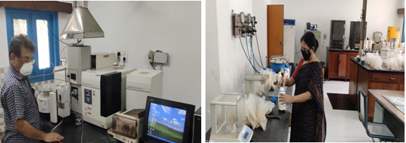 Cartography
The section is equipped with huge number of topographical sheets, aerial photographs,satellite images, miscellaneous maps and diagrams, soil maps and atlases on various scales. Facilities for conventional drawing such as N.C. Scriber for lettering, drafting machine for drawing, optical pantograph for reduction and enlargement, planimeter and curvimeter for area processing, plan printer for plain paper reproduction and ammonia printing machine, nova trace etc. are available for cartographic work. Remote sensing equipments, such as mirror stereoscope, sketch master, parallel bar, stereo pentameter etc. are also used in the centre for visual interpretation of aerial photographs and satellite images for the preparation of base maps. In addition,lamination, and binding machine is also available to strengthen catography sectiion.
GIS Laboratory
The Regional Centre is well equipped with some of the latest computer systems and soft- wares with heavy duty work stations that help in data base management, data processing, analysis, storage and retrieval in bulk amount. Advanced software on Geographic Information System such as Arc GIS ver. 10.5, TNT mips, IGIS, QGIS, etc. are being used for regular GIS works viz., terrain modeling, landform analysis, accurate delineation of soil boundaries and generation of geo-referenced soil-database, soil and associated thematic and interpretative maps preparation and data mining. The laboratory is also equipped with Digital Image Processing Software (Image Analyst), Digital Elevation Model generating software (Terrain Analyst) and CAD software like Bentlay’s Micro-station, etc.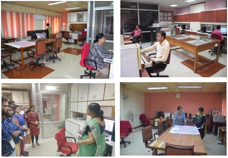
Soil Resource Information Centre (SRIC)
The Soil Resource Information Centre (SRIC) for Eastern Region pertaining to the states of West Bengal, Bihar, Jharkhand, Odisha and Union Territory of A & N Islands have been established at the Regional Centre, Kolkata of ICAR-NBSS & LUP for the use of policy makers, planners, research workers, user agencies as well as the students of schools, colleges and universities. The major objective was to prepare a brief record of the dominant soils occurring in the eastern region in the form of displaying macro monolith of the soils of various agro-ecosystem with their detailed properties and also to serve as a centre for documentation about the activities of the Regional Centre including human resource development programme pertaining to soil survey for land evaluation, generation of thematic maps using GIS technology and soil based agro-technology transfer towards rational land use plan. Geology of different physiographic regions of Eastern states, including a model of watershed, typical soil profile monoliths, sketch of representative landforms, soil-physiographic relationship, a sketch of different soil forming process in various landscape situations of Eastern region has been aesthetically displayed in SRIC.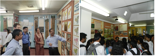
Library
A well-stocked library and documentation unit is prevailing in the Regional Centre. A comprehensive collection of books, journals, reports are present in the library. This caters to the need of the Scientists, Researchers and Post Graduate students and other technical staff of the institute for gaining vast knowledge in the field of natural resource management. The catalogue has been electronically updated every year for filtering the need of users as and when required. 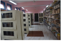
Human Resource Development Unit
The Regional Centre is enriched with well organized HRD unit, comprising well furnished air conditioned conference room and seminar hall for organizing lectures, seminars, symposia, workshops and conducting training programmes from time to time. 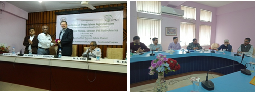
Residential Campus and Scientist Home
The Regional Centre, Kolkata consists of 28 Residential quarters and a Scientist Home having 17 rooms with a capacity of providing logistic facility to 34 guests at a time.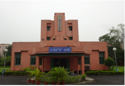
Soil resource mapping of Eastern region for planning at state level (1:250,000 scale)
The soils of the region was surveyed and mapped on 1:250,000 scale following three tier approach. Soil physiographic models were used for mapping the soils of the region and maps are published state wise on 1:500, 000 scale. The soil maps show 115, 119, 99, 159, 69 and 42 map units of soil family associations in West Bengal, Bihar, Jharkhand, Odisha and Andaman Nicobar Island, respectively. Inceptisols were the dominant soils in West Bengal, covering 49% area of the state, whereas, the extent of Alfisols and Entisols were 25 and 23 % area in the state. In Bihar, Inceptisols were the dominant soil order covering 42.4 % area of the state, whereas, the contributions of Alfisols, Entisols and Vertisols were 16.7, 36.8 and 0.3 %, respectively, in the state. In Jharkhand, Alfisols were the dominant soil order, covering 54.6 % area of the state. In Odisha, Inceptisols cover 48.8 % area , whereas, the extent of Alfisols, Entisols and Vertisols were 33.5, 10.2 and 5.52% of area of respectively.
Soil resource mapping for district level planning (1:50,000 scale)
District level soil resource mapping has been accomplished on 1:50,000 scale with soil series association as mapping unit. The exercise has been completed for Bankura, Barddhaman, Birbhum, Hughli, Kochbihar, Nadia and Purulia districts of West Bengal; Madhubani district in Bihar; Lohardaga and Ranchi districts in Jharkhand; Puri and Sambalpur districts in Odisha and South Sikkim district in Sikkim.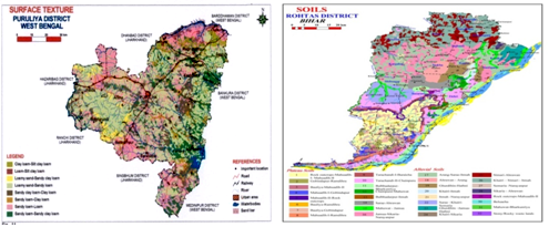
Nutrient status mapping for soil health monitoring
District level soil nutrient mapping status mapping has been accomplished in Jharkhand, West Bengal and Sikkim at 2.5 km, 1.0 km and 0.5 km grid interval, respectively. The spatial database has been created in Arc GIS 9.3 using spatial interpolation technique by geo-statistical method. In West Bengal, about 52.3 to 81.8 % of area was affected with slight to strong acidity, 55 to 92.9 % of area under potassium deficiency, 48 to 88 % of area under phosphorus deficiency and 59.7 to 83.3 % of area under zinc deficiency. In Jharkhand, soils of about 49 % of the state are extremely to strongly acidic and 36% area under moderate to slight soil acidic.. Block level soil nutrient mapping of 38 blocks of Dumka, Jamtara, Hazaribagh and Ramgarh districts of Jharkhand has also been performed at 500 m grids interval. The data indicate that multi-nutrient deficiencies of phosphorous, nitrogen, sulphur, boron and soil acidity problems had been the reasons for low agricultural productivity in these districts.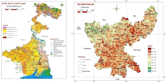
Established soil series for developing benchmark sites in the region
The response of similar soil families to the management and their performance with respect to the crop productivity are not alike because of inherent variability in the soils. The variability in soils of the same families was further narrowed down by establishing soil series in the region. In the process data collected during soil resource mapping of India on 1:250,000 scale; data recorded during district surveys and the soil survey data of other state agencies were utilized. The information on soil series is published in the shape of bulletins for each state of the region. The soil series in the bulletin is described with respect to its type location, physiographic position, ground water table, rainfall, slope, erosion, relief, drainage, permeability, land use, geology and parent material, extent and distribution, associated soils and soil correlation. The soil series description also contains typifying pedons, range in characteristics, interpretations (constraints, suggested land use and potential yield), actual crop yield and analytical soil data. Total 62 soil series are established in the region comprising 38 soil series in West Bengal, 2 soil series in Bihar, 6 soil series in Jharkhand, 11 soil series in Odisha and 5 soil series in Sikkim.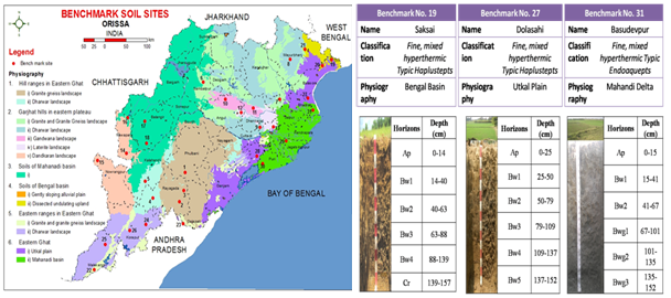
Soil erosion assessment for monitoring degradation status
Following multi-criteria overlay, several critical parameter of soil erosion was integrated in GIS for West Bengal, Odisha, Jharkhand, Bihar and Sikkim for developing quantitative soil erosion of different states of the region.
West Bengal
Central and southern part of the state covering around 79.8 % area was very slightly (loss of soil estimated < 5 ton/ha/yr.) to slightly (loss of soil estimated 5-10 ton/ha/yr.) eroded, while eastern Himalayas and undulating terrain of western region, covering 19.8 % area of West Bengal was moderately (loss of soil estimated 10-15 ton/ha/yr) to severely eroded (loss of soil estimated 20-40 ton/ha/yr.) A part of eastern Himalaya and the adjoining region, occupying another 0.39 % area of the state was very severely eroded (loss of soil estimated 40-80 ton/ha/yr).
Bihar
The soil erosion map of Bihar indicated that the central and northern parts in 87 % area of the state were very slightly to slightly eroded. The hilly area of eastern Himalayas and undulating terrain of southern part, covering another 12.4 % area of the state were moderately to severely eroded. Rohtas, Paschim Champaran and Kaimur region, representing 0.6 % area of Bihar were very severely eroded.
Jharkhand
Soil erosion map of Jharkhand showed that about 65% of TGA of the state has been affected by soil erosion crossing the soil loss tolerance limit. Severe to extremely severe soil loss pertains to 36.8% of TGA of the state, especially in the districts of Ranchi, Bokaro, Dhanbad and Hazaribagh.
Odisha
Soil erosion map of Odisha elucidates that Coastal and Garhjat plains, a part of Mahanadi basin and Dandakaranya on 7.7 million hectare land were very slightly eroded. Another 2.8 million hectare area in Mahanadi basin was slightly eroded, while a part of Eastern ghat and Garhjat hills, covering 4.1 million hectare land in the state was moderately to severely eroded. Very severe and extremely severe eroded soils were located in the hilly terrain of Eastern ghat and Garhjat hilly area.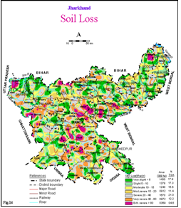
Assessment of Distribution and Extent of Acid Soils of Eastern States
Acid soils occupy about 90 M ha (more than 25% of TGA of the country) and are spread across Himalayan Region, Eastern and North-eastern Plains, Peninsular India and Coastal Plains. About 25 Mha of cultivated lands comprise chemically degraded acid soils soil with pH <5.5. The assessment revealed that 84.9% of total geographical area (TGA) of Jharkhand has been affected by soil acidity, whereas, for West Bengal, Odisha, Bihar and Sikkim the distribution of acid soils were estimated as 53.6, 85.3, 55.7 and 25.1% of TGA of respective states.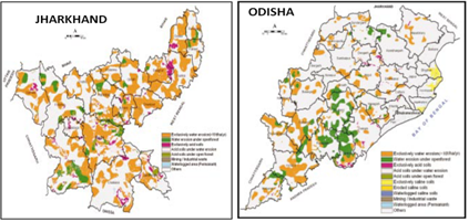
Agro-ecological zoning of West Bengal
For delineating the uniform area with respect to climate, soils and land use, agro-ecological maps have been prepared within the agro-ecological region and sub-regions by superimposing bio-climate, length of growing period map, soils and landforms on 1:1 million scale in GIS. In the exercise twenty nine agro-ecological zones have been carved out for West Bengal (Fig.). For further narrowing down the variability agro-ecological unit map has been delineated within agro-ecological zones by superimposing LGP (10 days interval based on actual AWC), bio-climate on soil physiographic maps.
Characterization and Delineation of Prime Lands of West Bengal
Prime lands were delineated separately for red and lateritic and alluvial tracts and later on combined to obtain the tentative prime agricultural land map for the whole state. The exercise revealed an area of 33929.45 sq.km (38.23 % of TGA) and 3818.79 sq.km (4.3 % of TGA) in alluvial and red and lateritic tract, respectively as prime lands which accounts for 50182.66 sq.km (56.54 % of TGA) in the state.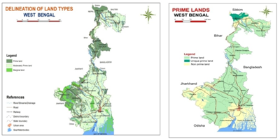
Characterization of Simana Sub-watershed in Subarnarekha Catchment, West Bengal for Land Use Planning using IRS Data
Reconnaissance soil survey was carried out in Simana subwatershed (9100 ha), West Medinipur, West Bengal. Twenty soil series were identified and mapped into 21 soil mapping units. Soils are classified in Alfisols (35.8%), Inceptisols (57.9%) and Entisols (6.3%). Various soil based thematic maps were prepared and a rational land use options were suggested.
Watershed level soil survey work accomplished
West Bengal
- Upper Kasai Watershed, Purulia district,
- Patloi Nala micro-watershed, Hura block, Purulia distrct,
- Simana sub-watershed, Jhargram sub-division, West Medinipur district,
- Silai Basin, Rarh Region, Bankura and Purulia districts,
- Mamring watershed in Darjiling district, West Bengal;
- Major Watersheds in Tista Basin,
Jharkhand
- Subarnrekha watershed, Ranchi district,
- Tilsimani Nala micro-watershed, Kanke block, Ranchi district,
- Potpota watershed (Muramu Cluster), Bero block, Ranchi district,
- Jumar Sub-Watershed, Ranchi district,
Bihar
- Gurusti Nala Watershed, Palamu, Bihar.
Odisha
- Kanchinala micro-watershed, Puri, Odisha,
Sikkim
- Mini Watersheds of the River Tista, Namthang Circle, South Sikkim,
- Singhik Subwatershed, Mangan, North Sikkim,
- Chalumthang Microwatershed, Sikkim;
Village/Research Farm level soil survey work accomplished
State : West Bengal
- Detailed soil survey of Jute Agri. Res. Institute (ICAR), 24-Parganas (N).
- Seven village of Sonarpur PS, 24-Parganas district (S).
- Sagar Island, 24-Parganas district (S).
- Bagnan, district Haora, West Bengal.
- Debra and Tamluk, Medinipur district.
- Tufanganj and Dinahata, Kochbihar.
- Soils of Singibhita Mouza Comprehensive area development corporation, Silliguri-Nakshalbari project, district Darjeeling.
- Soils of Ratua comprehensive area development project, District Malda, West Bengal.
- Soils of Gelia and Maynapur group of villages, Jaypur PS Indo-British Fertilizer Education Project, Bankura dist.
- Soils of Deganga comprehensive area development project, District 24-Parganas (North).
- Detailed Soil Survey for Land Use Planning of BCKV Central Farm (Gayashpur), Nadia
- Detailed Soil Survey for Land Use Planning, Chakdah Farm, BCKV, Dist. Nadia, West Bengal.
- Soils of IVRI Farm (ICAR), Kalyani, Nadia district
State: Jharkhand
- Detailed soil survey of Indian Lac Research Institute Farm, Namkum
- Detailed Soil Survey of Shankarpur and Masipiri Farms of Central Rainfed Upland Rice Research Station (ICAR), Hazaribagh, Jharkhand
- Central Horticultural Experiment Station, PS. Namkum and Hatia, District Ranchi.
- Operational Research Project Area, Chama and Barhu villages, Kanke PS., Ranchi district.
State: Odisha
- Soil Survey of the Land Colonization Project at Kanijodi, Dist. Koraput, Odisha
- Soil survey report of Central Tuber Crops Research Institute Farm (ICAR), Aiginia, Bhubaneswar, Odisha
- Soil survey report of Sisal Research Farm.
- Soils of Central Rice Research Institute Farm, Cuttack
UT: Andaman and Nicobar
- Detailed soil survey of ICAR Farm, Village Pronthropur, Tehsil
Others
- Soil resources of Jaldapara Researved forest, Jalpaiguri dist.
- Soil resources of Garumara Researved forest, Jalpaiguri district.
- Forest soils of Medinipur dist.
- Forest soils of Bankura district.
- Forest soils of Puruliya district.
- Development of regional scale watershed plans and methodo-logies for identification of critical areas for prioritized land treatment in the watersheds (NATP-RRPS-17).
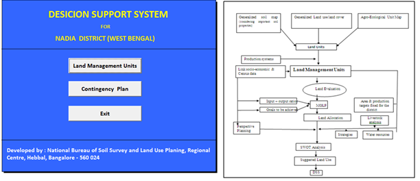
District level land use planning of Nadia, West Bengal at 1: 50,000 scale (Lower Gangetic Plains-Bengal Basin-AESR 15.1)
All the LMUs were evaluated for identifying economically viable and bio-physical suitable crops and cropping systems. Nine LMUs were delineated in the district. Different constraints were identified in each farming system and options were suggested to improve the productivity of crops. Evaluation of soil site suitability for different crops revealed that 22.7, 15.4, 9.5 and 5.1 per cent area of the district are highly suitable for rice, jute, rapeseed/mustard and groundnut respectively and about 44, 19, 80, 79, 42, 20 and 30 per cent area of the district are moderately suitable for rice, wheat, jute, rapeseed/mustard, sesame, sugarcane and groundnut respectively. Multiple Goal Linear Programme (MGLP) model has allocated area for different crops with respect to each defined goal. Expected net returns per ha varied from Rs.24,578/- to Rs.29,053/-.under different objectives and to achieve this different crop combinations have been suggested by the model. Decision Support System (DSS) of Nadia district was thus developed by including all the steps involved in land use planning exercise as a capsule in MS-Access for district planners including contingency planning of the district.
Land Resource Inventory Technology (at 1: 10,000 scale) at block/ district level
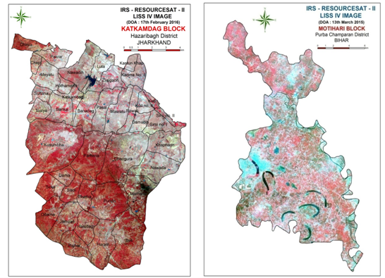
The Regional centre has accomplished land resource inventory (LRI) in 8 agro ecological sub regions (AESR 11.0, 12.1, 12.2, 12.3, 13.1, 15.1, 15.3 and 18.5) of Eastern states of India covering 22 blocks of 18 districts of 4 states including Bihar, Jharkhand, Odisha and West Bengal, covering a total geographic area (TGA) of 6,47,851 hectares. IRS Resourcesat 2 LIS IV as well as open source RS data viz., Sentinel-2 imageries along with 3-dimensional surface data like Shuttle Rudder Topographic Mission (SRTM), ASTER-digital elevation model, etc. for accurate delineation of land use –land covers and landform analysis in GIS platform at 1: 10,000scale. Landform analysis revealed micro-topographic variability of geomorphic features with varying slope classes. Landscape ecological unit (LEU) is the unique composition of land use-land covers, landforms and slope, which, represents agro-ecological environment of a given area. This is the basis for soil survey work. The entire procedure is highly effective to reduce time, manpower, energy and overall cost of land resource inventory, efficiently. Use of fine resolution remotely sensed data in GIS environment followed by ground truth verification processes are appeared to be highly useful tools for identification and mapping of prime lands, barren and waste lands, gullied and other degraded lands, fallow lands, forest covers, etc. without compromising the risks of mapping error. The present endeavour lucidly illustrates soil-landform relationship at micro-topographic variability for accurate delineation of soils at 1: 10,00 scale towards site specific management and planning. District level land resource inventory programme (at 1: 10,000 scale) has also been initiated for 8 districts of 4 states, namely, Hazaribagh (AESR 11.0) and Sahibganj (AESR 12.3 and 15.1) of Jharkhand, Jalpaiguri (AESR 15.3), Nadia (AESR 15.1), Murshidabad (AESR 15.1) and Maldah (AESR 15.1) of West Bengal, Katihar (AESR 13.1) of Bihar and Bolangir district (AESR 12.1 and 12.2) of Odisha. Delineation of landscape ecological units (LEU) was accomplished in 120 blocks of 8 districts of 4 states covering a total geographic area of 32,16,300 hectares.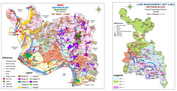
Developing Optimal Agricultural Land Use Plan and Assessment of Economic Impact of Land Resource Inventory
For impact assessment of LRI, the economic performances of crops, plantations, fishery, etc. have been evaluated in three distinct phases viz., (i) traditional or existing cropping/ land use systems, (ii) LRI based suggested alternate cropping/ land use systems and (iii) LRI based land use plan with best management practices (BMP). Economic impact of LRI was assessed for each LMU considering average annual Benefit: Cost (B: C) ratio and average annual net returns (NR) per hectare of land under each phase as indicators. Impact assessment was evaluated in 23 blocks of 18 district of 4 states. It was revealed that, in Dumka block of Dumka district (Jharkhand) and in Katkamdag block of Hazaribagh district (Jharkhand), B:C ratio in LRI based LUP with BMP were increased by 133% and 94%, respectively compared to existing system. On the other hand, benefit to cost ratios was only 31.4% in Chakia block of East Champaran district (Bihar) and 35.5% in Kadwa block of Katihar district (Bihar). The lower impact in Kadwa and Chakia blocks were attributed to moderate to severe salinity, moderate alkalinity and high calcareousness of soils along with and coarse silty texture of soils and severe flooding problems. Impact assessment of LRI based land use plan (with BMP) has revealed benefit to cost ratio in LRI based LUP with BMP ranging from 2.07 in Ganjam block of Ganjam district (Odisha) to 2.78 in Maynaguri block of Jalpaiguri district (West Bengal).
Sustainable Agricultural Land Use Planning of Aspirational Districts of Eastern India
As per the Recommendations of NITI-Aayog, Govt. of India, sustainable agricultural land use planning of 45 Aspirational districts of Bihar, Jharkhand, Odisha and West Bengal has been undertaken. Landform delineation of 24 districts has been accomplished using Sentinel-2 data along with SRTM-DEM as base map. Sustainable agricultural land use plan with geo-referenced soil data base has been uploaded in Aspirational District Dash Board of Bhoomi geo-portal for 4 districts of West Bengal (Nadia, Murshidabad, Maldah and Dakshin Dinajpur), 5 from Bihar (Araria, Begusarai, Katihar, Sitamarhi and Sheikhpura), 2 from Odisha (Kalahandi and Rayagada) and 2 from Jharkhand (Pakur and Sahibganj).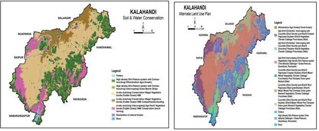
Soil Health Card Programmes
Soil health card programmes were launched in Gosaba block of South 24 Pgs. District of West Bengal during 2016-17 and in Motihari block of East Champaran district, Bihar during 2017-18 and 2018-19. In Gosaba block, 250 soil health cards were distributed to the farmers. In Motihari block, 1700 and 450 soil heath cards were distributed to the farmers of Piprakothi and Motihari blocks, on the occasions of Krishi Kumbh during 10-12th April of 2018 and 2019, respectively, in gracious presence of the Hon’ble former Union Minister of Agriculture, Govt. of India. 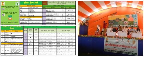
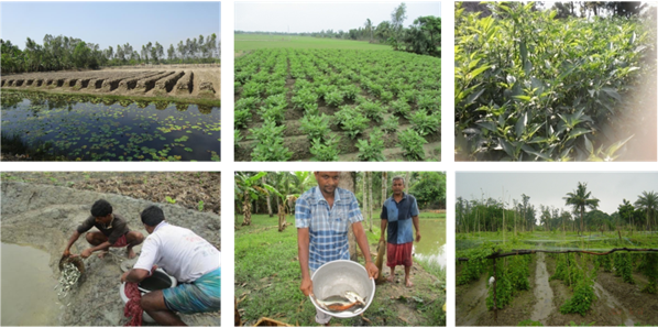
Up scaling of Land Shaping Technology in Gosaba block, South 24 Parganas district for enhancing livelihood of the farmers in coastal region of West Bengal under Lower Gangetic Delta & Coastal Eco-system (AESR 18.5) (under SCSP & STC Programme)
A three tier land use planning approach through land shaping technology facilitated in managing soil and water resources for enhanced crop production towards improving livelihood security of the farmers. Major interventions were: (i) Land shaping techniques (land modification through farm pond, deep furrow and high ridge, shallow furrow and medium ridge and paddy-cum-fish cultivation); (ii) Improved and salt tolerant paddy varieties; (iii) Multiple cropping/ crop diversification (low water requiring cropsc); (iv) Improving homestead production system; and (v) Promotion of vermi-composting and green manuring for reducing input cost. For LMU-1, Water harvest structure (pond) was recommended. Pond dykes may be utilized for fruit crops and multipurpose tree species (MPTS). Uplands were utilized for vegetable cultivation throughout the year. Mid lands were utilized for pulses, oilseeds during the rabi season and paddy during the kharif season and low land was utilized for paddy-fishery. For LMU-3, Paddy-cum-fishery with land shaping technology was adopted). Winter and summer vegetables can be grown on the dykes of the trenches. During rabi season, pulses, oilseed crops can be grown with life saving irrigation water in trenches Economic impact of alternative land management options revealed that the cropping intensity increased to 283% in LMU-1, 296% in LMU-2 and 257% in LMU-3 compared over the baseline 112% (existing). Overall, integrated multiple cropping-cum-fishery increased the average annual net income to Rs. 1,58,730/ ha, including income from vegetables cultivation (Rs. 1,89,266/ ha), paddy (Rs. 39,897/ ha) and pond fisheries (Rs. 1,78,058/ ha). Impact assessment in this endeavour revealed that the beneficial impact on livelihood security has been increased by 7.07 to 9.59 times in different land management units with respect to existing sets of management. One farmer, named Sh. Biswajit has now become a role model among the farmers of the village and has been recognized and awarded as best progressive farmer of Gosaba block by ICAR-CSSRI, Regional Station, Canning Town during celebration of Farmer’s day on 19.10.2016.
Implementation of agricultural land use planning of Kultali block of 24 Pgs(S), West Bengal (Lower Gangetic Delta & Coastal Eco-system-AESR 18.5)
In each land management unit (LMU) of the block, Aile system of land shaping technology with best management practice (BMP) was adopted to carry out package of practices. The impact analysis showed that Land shaping technology (Ail system) in LMU3 increased the system productivity ranging from 57.0 to 118.0% in different category of famers. The corresponding increase in net return of the system increase by 121 to 248% with paddy equivalent yield ranging from 2.71 to 3.05.
Institute funded project
- Land resource inventory of Sahibganj district, Jharkhand at 1:10000 scale using geospatial techniques.
- Land resource inventory of Murshidabad district, West Bengal at 1:10,000 scale using geospatial techniques.
- Land resource inventory of Maldah district, West Bengal at 1:10,000 scale using geospatial techniques.
- Land resource inventory of Nadia district, West Bengal at 1:10,000 scale using geospatial techniques.
- Land form identification and mapping of aspirational districts of Eastern India.
- Development of land resource inventory based long-term soil organic carbon restorative land use plan in humid sub-tropical region of Eastern India (Jalpaiguri district).
- Agricultural land use planning to enhance productivity and livelihood security of farming community of Majherpara village of Canning-II block, South 24 Parganas district, West Bengal (SCSP Programme)
Externally funded project
- Land resource inventory of Cinchona and other medicinal plants growing area of Darjeeling district on larger scale using geo-spatial techniques