

About Regional Center : Delhi
ICAR-NBSS&LUP, Regional Centre, Delhi is one of the oldest center of National Bureau of Soil Survey and Land Use Planning, and is involved in soil resource mapping, soil correlation & classification, land use planning, and undertaking pedological research and assessment of soil/land degradation status in Northern Region of the country comprising the states of Haryana, Himachal Pradesh, Punjab, Uttar Pradesh and Uttarakhand, and Union territories of Chandigarh, Delhi, Jammu & Kashmir and Ladakh . Total area under its jurisdiction is about 66.8 million ha which covers approximately one fifth of total geographical area of the country. By virtue of its location in the capital as also in the heart of the vast Indo – Gangetic alluvial plain, the center ranks as a pride with immense responsibility towards managing the natural resources in the high intensity agricultural zone of the country. Besides IGP, Centre is also taking care of diverse and fragile ecosystem of western Himalayas. This center is presently located in sprawling green campus of Indian Agricultural Research Institute (IARI), New Delhi.
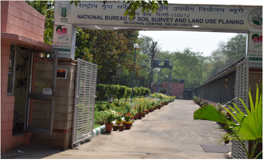
ICAR- NBSS&LUP, Regional Centre, Delhi
List of Scientists
| Sr.No. | Name | Designation | Discipline | Biodata | PMS | |
|---|---|---|---|---|---|---|
| 1 | Dr. (Mrs) Jaya N. Surya | Principal Scientist & Head | Soil Science | Jaya.Surya@icar.gov.in | View Biodata | PMS |
| 2 | Dr. Ashok Kumar | Senoir Scientist | Agronomy | Ashok.Kumar42@icar.gov.in | View Biodata | PMS |
| 3 | Dr. Rajesh Kumar Meena | Scientist | Soil Science | Rajesh.Meena2@icar.gov.in | View Biodata | PMS |
| 4 | Sh. Vikas Joon | Scientist | Agricultural Statistics | Vikas1@icar.gov.in | View Biodata | PMS |
| 5 | Dr. Sunil Kumar | Scientist | Soil Science | Sunil.Kumar26@icar.gov.in | View Biodata | PMS |
| 6 | Ms. Ritu Nagdev | Scientist | Environmental Science | Ritu.Nagdev@icar.gov.in | View Biodata | PMS |
Infrastructure
The physical facilities available at the centre include:
- Central Analytical Laboratory:
- Land Use Planning Section:
- Soil Survey Unit:
- Cartography & GIS Section:
- Priority setting, Monitoring and Evaluation (PME) Cell:
- Library:
- Administrative Unit:
Achievements
1.Institute Funded Projects
C)Land Degradation Mapping of Northern States (1:250,000 scale) This project was under taken in collaboration with NRSC, Hyderabad. The land degradation status of all the northern states has been generated.Soil Resource Mapping at District Level (1:50,000 scale).The status of soil survey and mapping in different districts is given in following tables. The description of soil survey and mapping of some of districts is given as below:
- Soil Resource Mapping of States in Northern Region
- Soil Resource Mapping of Jammu & Kashmir State on 1:250,000 scale:
- Soil Resource Mapping of Himachal Pradesh state on 1:250,000 scale:
- Soil Resource Mapping of Uttar Pradesh (including Uttrakhand) state on 1:250,000 scale:
- Soil Resource Mapping of Punjab state on 1:250,000 scale:
- Soil Resource Mapping of Haryana state on 1:250,000 scale:
- Soil Resource Mapping for Delhi State (on 1:125,000 scale) :
- B. Soil Erosion status of Northern States (1:250,000 scale)
- Soil Erosion in Himachal Pradesh:
- Soil Erosion in Punjab:
- Soil Erosion in Haryana:
- Soil Correlation of Northern States:
| State | Soil series entered in National Register | Year |
| Himachal Pradesh | 1. Ropri serial No. 235 State Code HP001 2. Dehra serial No. 236 state code HP002 3. Bhager serial No. 254 State code HP005 4. Hatwar serial No. 255 State code HP006 5. Kelol serial No. 256 State Code HP007 6. Rajpura serial No. 257 State Code HP008 | 2009 2009 2010 2010 2010 2010 |
| Jammu & Kashmir | 1. Khitoli serial No. 231 State Code JK002 2. Aharbal serial No. 232 State Code JK003 | 2009 2009 |
| Uttar Pradesh | 1. Shergarh serial No. 239 State Code UP004 2. Nagaria serial No. 240 State Code UP005 | 2009 2009 |
- Soil Resource Mapping of Bilaspur district (H.P.):
- Soil Resource Mapping of Patiala district of Punjab state:
- Dynamic of land use change and its impact on soil properties in Shahid Bhagat Singh Nagar(formerly Nawanshahr) district, Punjab state:
- Land Resource Inventory for Farm Planning in Lakhan Majra Block, Tehsil and District Rohtak, Haryana:
- Land Resource Inventory of Jagner Block of Agra District, Uttar Pradesh on 1:10000 Scale For Agricultural Land Use Planning:
- Alternate Land Use Options for Upper Indo-Gangetic Plain region towards Sustainable Crop Production and Livelihood Security- A Case Study of Chhata Tehsil of Mathura District in Uttar Pradesh.
- Agricultural Land Use Planning in the Western Himalayan Regions of India Using Land Resource Inventory Database on 1:10000 Scale-A Case Study of Nagrota Bagwan Block of Kangra District in Himachal Pradesh
- Consultancy Projects:
- Soil Resource Mapping of Mathura district of U.P. state:
- Soil Resource Mapping of Firozabaddistrict of U.P. state
- Soil Resource Mapping of Shahjahanpur district of U.P. state
- Soil Resource Mapping of Sultanpur district of U.P. state:
- Soil Resource Mapping of Mainpuri district of U.P. state
- Soil Resource Mapping of Moradabad district of U.P. state:
- Soil Resource Mapping of District Etawah of Uttar Pradesh for Perspective land Use Planning (1:50,000 Scale).
- Soil Resource Mapping of District Muzaffarnagar, Uttar Pradesh for Perspective land Use Planning (1:50,000 Scale) under the Project Soil Resource Mapping and Digitization of 7 Districts of Uttar Pradesh – UP-RSAC-project.
- Soil Resource Mapping of District Meerut Uttar Pradesh for Perspective land Use Planning (1:50,000 Scale).
- Inter-Institutional Projects :
- Assessment and mapping of salt affected soils using remote sensing and GIS in southern district of Haryana state (Inter Institutional Collaborative Project -with ICAR-CSSRI, Karnal )
- Externally Funded Projects:
- Generation of Soil Database for Khulgad Watershed Development in Almora District, Uttarakhand(DST Sponsored Project –Under DST Co-ordinated Research programme on “Bio-Geo Database and Ecological Modeling for Himalayas” –Uttarakhand Study Transect)
- Soil Resource Distribution, Characterization, Evaluation and Constraints for Cotton Based Cropping System in Irrigated Ecosystem of North India–A Case Study of Sirsa District of Haryana:
- Detailed Soil Survey of Ladhowal Farm (DMR site) Ludhiana, District Ludhiana, Punjab for land evaluation:
- Research Study on – Soil Samples Collection and Testing for its Quality Check for Assessing Soil Health Card (SHC) Scheme (Funded byNational Institution of Transforming India (NITI) Aayog , New Delhi )
- ICAR National Agriculture Science Fund (NASF) sponsored -Bioremediation of chemical contaminants and their complex present in drainage waste water with high dynamix flux used for irrigation in urban and peri-urban agriculture.
Ongoing projects
- Soil correlation in Northern Region
- Soil resource mapping of Almora district (Uttarakhand) for perspective land use planning.
- Soil resource mapping of Sultanpur district (U.P.) for perspective land use planning.
- Dynamics of land use and its impact on soil development in Jalandhar district, Punjab state.
- Development of district level land use plan for Almora district, Uttarakhand under hill and mountain ecosystem.
- Soil Resource Inventory of IARI Farm, New Delhi.
- Soil resources – their assessment for horticulture in Shimla district of Himachal Pradesh
- Land use dynamics in rural-urban interface of NCR for regional planning – a case study of NCT-Delhi and Haryana sub-regions.
- Studies on soil minerals and their genesis in selected Benchmark soils representing different agro-eco-sub regions of India
- Land use planning of Buraka Micro-watershed in Mewat district of Haryana under Irrigated Ecosystem for integrated development.
- Ongoing Institute LRI Flagship Projects:
Blocklevel (NON-DSM) Project:
- Land Resource Inventory on 1:10,000 scale of Nagrota-Bagwan Block, Kangra district, Himachal Pradesh for optimal Agricultural Land Use Planning.
- Land Resource Inventory of Odhan Block, Sirsa district, Haryana on 1:10,000 scale for optimal Land Use Planning.
- Land Resource Inventory on 1:10,000 scale of Rajpura block, Patiala district, Punjab for optimal Agricultural Land Use Planning.
- Land Resource Inventory of Chamba Block of Tehri Garhwal district, Uttarakhand on 1:10000 scale for Agricultural Land Use Planning.
- Land Resource Inventory of Baragaon blockof Varanasi district, Uttar Pradesh on 1:10,000 scale for Agricultural Land Use Planning.
- Land Resource Inventory (1:10000 scale) of Lahul Block, Lahul & Spiti District, Himachal Pradesh for Development of Soil Health Card and Agricultural Planning.
- Land Resource Inventory (1:10000 scale) of Pangi block of Chamba district, Himachal Pradesh for agricultural Land Use Planning.
- Land Resource Inventory (1:10,000 scale) of Dhanpatganj block of Sultanpur District, Uttar Pradesh for agricultural land use planning: part of Mapping and assessment of Land Degradation in Major Ecosystems of India using Geospatial Technologies.
- Land Resource Inventory on 1:10,000 scale of Leh Block, Leh-Ladakh district, J&K for Agricultural Land Use Planning by using Geo-spatial techniques.
- Land Resource Inventory of Bhimtal Block of Nainital district, Uttarakhand on 1:10000 scale for Agricultural Land Use Planning.
District level (NON-DSM) Project:
- Land Resource Inventory of Patiala district, Punjab on 1:10000 scale for Agricultural Land Use Planning.
- Land Resource Inventory of Shahid Bhagat Singh Nagar district, Punjab on 1:10000 scale for Agricultural Land Use Planning.
- Land Resource Inventory of Sirsa district, Haryana on 1:10000 scale for Agricultural Land Use Planning.
Regional level (DSM) Project:
- Land Resource Inventory of Bundelkhand Region for Sustainable Agricultural Land Use Planning.
- Digital soil mapping of India (Indian Soil Grid Project): Digital soil mapping of Northern States under jurisdiction of regional Centre Delhi.
- Ongoing LUP Projects:
Block level:
- Agricultural land use planning of Baragaon Block of Varanasi district, U.P. using Land Resource Data on 1:10,000 scale.
- Agricultural land use planning of Rajpura Block of Patiala district, Punjab using Land Resource Data on 1:10,000 scale.
District level:
- Sustainable Agricultural Land Use Planning for Aspirational Districts of Northern India- Moga District, Punjab.
- Sustainable Agricultural Land Use Planning for Aspirational Districts of Northern India- Udhamsingh Nagar District, Uttarakhand.
- Sustainable Agricultural Land Use Planning for Aspirational Districts of Northern India- Haridwar District, Uttarakhand.
- Sustainable Agricultural Land Use Planning for Aspirational Districts of Northern India- Chamba district, Himachal Pradesh.
- Sustainable Agricultural Land Use Planning for Aspirational Districts of Northern India- Mewat district, Haryana.
- Sustainable Agricultural Land Use Planning for Aspirational Districts of Northern India- Ferozpur district, Punjab.
- Agricultural Land Use Planning for Indo-Gangetic Plain Regions of India towards Sustainable Crop Production and Livelihood Security- A Case Study in Mathura District of Uttar Pradesh.
Capacity Building
Summer School / Winter School / Trainings Organised
- G.S. Sidhu, acted as Regional Coordinator of NNRMS (ISRO) sponsored 21 days training programme on “Application of Remote Sensing and GIS in natural resource management”, during 16th January to 5th February, 2013.
- J.P. Sharma, Dr. G.S. Sindhu and Dr. S.K. Mahapatra organized field orientation training programme for scientists/technical officers of the Bureau, during 30.03.2009 to 09.04.2009 at ICAR-NBSS&LUP, Regional Centre, Delhi.
- J.P. Sharma acted as Regional Coordinator of NNRMS (ISRO) sponsored 21 days training programme on “Application of Remote Sensing and GIS in soil resource mapping towards land use planning, during 16th January to 5th February, 2007.
- Institute level training programmes-Institutional
- Soil Resource inventory and land evaluation
- Geographic Information System (GIS) for land resource data management.
- Land evaluation for command area development
Conferences / Seminars / Symposiums / Workshops Organised
- S.K. Mahapatra as organizing secretary organized 22nd Annual Convention and National Conference on “Application of Clay and Allied Sciences in Agriculture, environment and Industry”, during 23-24 September, 2019 at ICAR-IARI, New Delhi.
Ph.D Thesis - Guided
- S.K. Mahapatra and Dr. R.P. Yadav, Principal Scientist & Head acted as Co-advisor of shri Ashok Kumar, Scientist, ICAR-NBSS&LUP, Regional Centre, Delhi, in his Ph.D. thesis entitled “Land and Environmental Suitability Evaluation for Sustainable Agricultural Land Use Planning of Buraka Micro-watershed in Mewat Region of Haryana”, submitted to MPUAT, Udaipur, Rajasthan (2020).
Internships - Guided
- Tarsem Lal, Principal Scientist and Dr. RP Yadav, Principal Scientist & Head acts as a mentor of Dr. (Mrs.) Shrila Das, Scientist (P), Division of Soil Science, IARI, New Delhi, during her Professional Attachment Training on “Land Resource Inventory of Richoha Micro-watershed of Kheragarh Tehsil, Agra District, Uttar Pradesh”, from 21.05.2015 to 20.08.2015.
Major Publications
Research Papers
2023
- Pallee Shree, Singh, C. K., Sodhi, K. K. Surya, Jaya. N. and Singh, D. K.2023. Biofilms: Understanding the structure and contribution towards bacterial resistance in antibiotics. Medicine in Microecology. 16(5):100084.DOI:10.1016/j.medmic.2023.100084. (Impact score: 3.97)
- Kumar, S., Phogat, V.K., Dahiya, R., Yadav, V., Meena, R.L., Nogiya, M., Yadav, L. P., Priya, H., Yadav, S. K., Tiwari, S. and Surya, Jaya N. 2023. Evolution of soil organic carbon under different cropping systems in hot arid region, India. Agricultural Mechanization in Asia Africa and Latin America, 54 (09), 15401-15407 (NAAS Rating: 6.30)
- Kumar, S., Phogat, V.K., Dahiya, R., Yadav, V., Meena, R.L., Nogiya, M, Yadav, L. P., Priya, H., Yadav, S. K., Tiwari, S. and Surya, Jaya N. 2023. Assessment of Poor-Quality Irrigation Water under Different Cropping Systems in Arid and Semi-Arid Region, India. Agricultural Mechanization in Asia Africa and Latin America, 54 (8), 15359-15367. (NAAS Rating: 6.30)
2022
- Ashok Kumar, Dilip Singh, S. K. Mahapatra (2022). Energy and carbon budgeting of the pearl millet-wheat cropping system for environmentally sustainable agricultural land use planning in the rainfed semi-arid agro-ecosystem of Aravalli foothills. Energy (246):123389. NAAS Rating: 13.15.
- Ashok Kumar, Dilip Singh, S. K. Mahapatra. 2022. Energy and carbon budgeting of the pearl millet-wheat cropping system for environmentally sustainable agricultural land use planning in the rainfed semi-arid agro-ecosystem of Aravalli foothills. Energy 246:123389. https://doi.org/10.1016/j.energy.2022.123389
- Jaya N. Surya, Ashok Kumar, Gaurav Singh, D. K. Singh, Neelam Patel. 2022. Comprehensive assessment of heavy metals contamination in soil and water in peri-urban areas of National Capital Territory, Delhi. Environment Conservation Journal. 23(1&2):1-7. https://doi.org/10.36953/ECJ.021821-2129.
- K. Yadav, N.L. Mali, Sunil Kumar, Jaya N. Surya, P.C. Moharana, Mahaveer Nogiya and R.L. Meena. 2022. Assessment of soil quality and spatial variability of soil properties using geo-spatial techniques in sub-humid southern plain of Rajasthan, India. Journal of the Indian Society of Soil Science 70(1): 69-85.
- C. Moharana, S. Dharumarajan, Nirmal Kumar, R.K. Jena, U.K. Pradhan, R.S. Meena, S. Sahoo, M. Nogiya, Sunil Kumar, R.L. Meena, B.L. Tailor, R.S. Singh, S.K. Singh and B.S. Dwivedi. 2022. Modelling and Prediction of Soil Organic Carbon using Digital Soil Mapping in the Thar Desert Region of India. Journal of the Indian Society of Soil Science 70(1): 86-96.
- C. Moharana, S. Dharumarajan, Nirmal Kumar, U. K. Pradhan, R. K. Jena, R. K. Naitam, Sunil Kumar, R. S. Singh, R.S. Meena, M. Nogiya, R. L. Meena and B. L. Tailor. 2022. Digital Mapping Algorithms to Estimate Soil Salinity in Indira Gandhi Nahar Pariyojana (IGNP) Command area of India. Agropedology, 31(02), 113-124.
- Surya, J. N., Kumar, A., Singh, G., Singh, D.K., Patel, N. (2022). Comprehensive assessment of heavy metals contamination in soil and water in peri-urban areas of NCT Delhi. Environment Conservation Journal. https://doi.org/10.36953/ECJ.021821-2129.
2021
- Ashok Kumar, Lal, S.K. and Meena, R.S. (2021). Management of Natural Resources in Indo-Gangetic Plain Region of India for Sustainable Agricultural Land Use Planning – A Case Study. Biological Forum – An International Journal, 13(2): 282-292.
- Ashok Kumar,K. Mahapatra and Jaya N. Surya (2021). Soil Suitability of Some Major Fruit Crops for Sustainable Production in the IGP Region of India-A Case Study. Biological Forum -An International Journal, 13(1): 200-210.
- Prabha Susan Philip and Anil Kumar, K. S. (2021). Soil fertility characterization of intensive rice-growing soils in selected agro-climatic zones of Karnataka. The Mysore Journal of Agricultural Sciences, 55(4): 253-261.
- Prabha Susan Philip and Anil Kumar, K.S. (2021). Characterization and classification of selected rice-growing soils in hilly zone of Karnataka. The Pharma Innovation Journal, 10(10): 757-760.
- Pradeep, Anil Kumar, K. S. and Prabha Susan Philip (2021). Characterization and classification of soils from southern agro-climatic zones of Karnataka, South India. International Journal of Environment and Climatic Change, 11(12): 119-129.
- Singh, T., Lal, B., Satapathy, B.S., Gautam, P., Kumar, A. and Pun, K.B. (2021). Effect of date of transplanting and nitrogen on productivity and profitability of rice-ratoon (Oryza sativa) system under shallow lowland. Indian Journal of Agronomy, 66(2): 149-156.
- Vikas, Yadav, R.P., Surya, J. N., Meena, R.K. and Ashok Kumar (2021). Delineation of Shivaliks in Eastern and North-eastern region of India using Modern GIS techniques. International Journal of Agriculture Science, 13(12): 10994-10997.
2020
- Ashok Kumar, Dilip Singh and S. K. Mahapatra (2020). Current and potential soil suitability of pearl millet, wheat and mustard for sustainable production in Aravalli foothills of Mewat Region of Haryana, India.International Journal of Current Microbiology and Applied Sciences, 9(5): 3566-3583.
- Jaya N. Surya, C.S. Walia, H. Singh, R.P. Yadav and S.K. Singh (2020). Soil Suitability Evaluation Using Remotely Sensed Data and GIS – A Case Study From Kumaon Himalayas. Journal of the Indian Society of Remote Sensing, 48(10): 1355-1371.
- Nagdev, R. and Mahapatra, S.K. (2020). Assessment of soil resources of Pauri-Garhwal district of Uttarakhand for sustainable productivity. Journal of Soil and Water Conservation, 19(1): 17-25.
- Surya, J. N., Walia C.S., Singh H., Goyal V., Dhankar R.P., Sharma J.P. and Sarkar, D. (2020). Assessment of Soils Fertility Status in Kumaon Himalayas Using GIS Technique. International Journal of Microbiology Research, 12(4): 1811-1815.
2019
- Ashok Kumar, Kadam, S.S., Yadav, R.P. and Singh, S.K. (2019). Tree fodder as an alternate land use option for sustaining forage security in India. Review paper. International Journal of Chemical Studies, 7(2):202-207.
- Ashok Kumar, Singh, Dilip and Mahapatra, S.K. (2019). Study of socio-economic indicators for sustainable agricultural land use planning of Buraka micro-watershed in Mewat Region of Haryana. Annals of Agricultural Research New series, 40(4):316-321.
- Mahapatra, S.K., Nagdev, R., Gopal, R., Surya, J.N., Meena, R.K., Yadav, R.P. (2019). Characterization and Classification of the Soils of Buraka Micro-Watershed in Haryana for Integrated Development. Journal of the Indian Society of Soil Science, 67(2):125-136.
- Mahapatra, S.K., Nagdev, Ritu, Yadav, R.P. and Singh,S.K. (2019). Characterization and Classification of the soils of Bino-river watershed in Almora district of Uttarakhand, India for perspective land use planning. International Journal of Current Microbiology and Applied Sciences, 8(3):207-222.
- Mangalassery, S., Rejani, R., Singh, V., Adiga, J. D., Kalaivanan, D., Rupa, T. R. and Philip, Prabha S. (2019). Impact of different irrigation regimes under varied planting density on growth, yield and economic return of cashew (Anacardium occidentale). Irrig Sci., 37: 483-494. https://doi.org/10.1007/s00271-019-006257.
- Meena, R.L., T.P. Verma, R.S. Singh, P.C. Moharana, Sunil Kumar, Mahaveer Nogiya, B.L. Tailor, R. Singh and Singh, S.K. (2019). Soil-Site Suitability and Production Potential Evaluation of Chickpea (Cicer arietinum) under Arid Climate of Western Rajasthan, India. Journal of Current Microbiology and Applied Sciences, 8(4): 2597-2607.
- Meena, Rajesh Kumar, Vikas, Verma, T.P., Yadav, R.P., Mahapatra, S.K., Surya, Jaya N., Singh,D.and Singh, S.K. (2019). Local perceptions and adaptation of indigenous communities to climate change: Evidences from High Mountain Pangi valley of Indian Himalayas.Indian Journal of Traditional Knowledge, 18(1): 58-67.
- Mangalassery, D. Kalaivanan, Prabha S. Philip (2019). Effect of inorganic fertilisers and organic amendments on soil aggregation and biochemical characteristics in a weathered tropical soil. Soil and Tillage Research, 187: 144-151.
- Nagdev, Ritu, Mahapatra, S.K., Yadav, R.P. and Singh, S.K. (2019).Delineation and characterization of the Takula watershed in Kumaon Himalayas for soil and water conservation. Journal of Soil and Water Conservation, 18(2): 99-108.
- Singh, T.P., Kumari, Jyoti, Sharma, R.K., Shivani, Kumar, Sunil and Sherry R. Jacob (2019). Morpho-physiological diversity in Indian spring wheat cultivars and identification of promising donor under terminal heat stress. Journal of Cereal Research, 11(2): 140-146.
- Surya, Jaya N., Katiyar, D.K., Ram Gopal, Yadav, R.P., Mahapatra, S.K. and Singh, S.K. (2019). Assessment of Groundwater Quality for Irrigation in Lakhan Majra Block of Rohtak District, Haryana. Journal of Soil Salinity and Water Quality, 11(1):63-67.
- Surya, Jaya N., Sidhu, G.S., Lal, T., Singh, D., Yadav, R.P. and Singh, S.K. (2019). Land evaluation of rice-wheat growing soils of central plains of Punjab for land use planning.International Journal of Current Microbiology and Applied Sciences, 8(1):2590-2601.
- Manoj Kumar, Ritu Nagdev, Ritu Tripathi, Virendra Bahadur Singh, Prabhat Ranjan, Mohd Soheb, AL. Ramanathan (2019). Geospatial and multivariate analysis of trace metals in tubewell water using for drinking purpose in the upper Gangetic basin, India: Heavy metal pollution index. Groundwater for Sustainable Development, 8: 122-133.
2018
- Kadam, S.S., Ashok Kumar and Mohd. Arif (2018). Zinc mediated agronomic bio-fortification of wheat and rice for sustaining food and health security: A review. International Journal of Chemical Studies, 6(1):471-475.
- Kumar, Sunil, Gulati, I.J., Yadav, S.R., Yadav, R.S., Moharana, Meena, R.L., Singh, R., Tailor, B.L., and Singh, R.S. (2018). Impact of low potassium fertilization on potassium transformation under different crop management systems in western plain of arid India. Journal of Plant Nutrition, 41(4): 411-424.
- Mahapatra, S.K., Reddy, G.P. Obi, Nagdev, Ritu,Yadav, R.P., Singh, S.K. and Sharda. V.N. (2018). Assessment of soil erosion in fragile Himalayan ecosystem of Uttarakhand using USLE and GIS for sustainable productivity. Current Science,115(1): 108-121.
- Mahapatra S.K., Nagdev, Ritu, Yadav, R.P. and Singh S.K. (2018). Identification and Characterization of the Soils of Paschimi Nayyar River Watershed in Lesser-Himalayan Region of India. International Journal of Current Microbiology and Applied Sciences, 7(2):2185-2197.
- Moharana, P.C., Singh, R.S., Singh, S.K., Jena, R.K., Naitam, R.K., Verma, T.P., Nogiya, M., Meena, R.L., Gupta, D.K., Kumar, Sunil, Tailor, B.L., and Singh, R. (2018). Assessment of soil quality monitoring indicators under long term rice cultivation in hot arid Ghaggar-flood plains of India. Archives of Agronomy and Soil Science, 64(14):2030-2044.
- Nagdev, Ritu, Mahapatra, S.K., Singh, S.K., Yadav, R.P. and Jaya N. Surya (2018). Role of soil clays for watershed management in Mewat region of Haryana. Clay Research, 37 (1): 23- 31.
- Prabha S. Philip, Kaleeswari, R.K., and Kumar, K. (2018). Microbial biomass-carbon (SMB-C) and dehydrogenase activity (DHA) in wetlandrice ecosystem. International Journal of Current Microbiology and Applied Sciences, 7(9): 384- 389.
- Surya, Jaya N., Vikas, Lal, T., Yadav, R.P., Singh, D., Katiyar, D.K., Nagdev, R. and Singh, S.K. (2018). Land Resource Inventory for and Characterization Planning Soil Conservation Measures in Aravalli Hill Slopes. International Journal of Current Microbiology and Applied Sciences, 7(4):725-735.
- Vikas, Veena Manocha and Goyal, S.K. (2018). Estimation of Acreage Response of Major Crops in Haryana using Co-integration Approach. International Journal of Current Microbiology and Applied Sciences, 7(3): 2890-2903.
2017
- Fagodiya, R.K., Pathak, H., Meena, B.L., Meena, R.K. and Nagdev, R. (2017). Need to estimate the net global warming potential of nitrogenous fertilizers. Advances in Plants and Agriculture Research,6(4): 99-100.
- Kadam, S.S., Ashok Kumar and Mohd. Arif (2017). Hybrid Napier for Round the Year Quality Fodder Supply to the Dairy Industry- A Review. International Journal of Current Microbiology and Applied Sciences, 6(10):4778-4783.
- Kumar, Ashok, Mahapatra, S.K., Lal, Tarsem, Yadav, R.P. and Singh S.K. (2017). Land evaluation for land use planning towards sustainable crop production – A Case Study of Chhata tehsil, Mathura District, Uttar Pradesh, India. International Journal of Current Microbiology and Applied Sciences, 6(9):859-870.
- Kumar, Ashok, Mahapatra, S.K., Lal, Tarsem, Yadav, R.P. and Singh S.K. (2017). Alternate Land Use Options for Livelihood Security of the Farmers – A Case Study of Chhata tehsil, Mathura District, Uttar Pradesh, India. International Journal of Current Microbiology and Applied Sciences, 6(7):279-295.
- Kumar, Sunil, Gulati, I.J., Yadav, S.R., Manisha, Moharana, P.C., Meena, R.L., Nogia, M. and Singh, R.S. (2017). Assessing of Potassium Reserve and their Relationship with Soil Properties in Western Plain of Arid India. International Journal of Current Microbiology and Applied Sciences, 6(9): 1-19.
- Meena, R.L., Verma, T.P., Singh, R.S., Tailor, B.L. and Singh, S.K. (2017). Soil-Site Suitability Evaluation for Groundnut (Arachis hypogaea) in Western Saurashtra Region of Gujarat, India. International Journal of Current Microbiology and Applied Sciences, 6(10):3074-3083.
- Moharana, P. C. Nagdev, Ritu and Burman, Uday (2017). Utilizing Geo-information Tools for Mapping Spatio-Temporal Changes in Population of Prosopis cineraria (khejri) in Agroforestry System of Arid western Rajasthan. Journal of Indian Society of Remote Sensing, 45(2):1-12.
- Mohrana, P.C., Naitam, R.K., Verma, T.P., Meena, R.L., Kumar, Sunil,Tailor, B.L., Singh, R.S., Singh, S.K. and Samal, S.K. (2017). Effect of long-term cropping system on soil organic carbon pools and soil quality in western plain of hot arid India. Archives of Agronomy and Soil Science, 63(12):1661-1675.
- Nagdev, R., Mahapatra, S.K. and Yadav, R.P. (2017). Assessment of Agri-Environment in Garhwal Himalayas of India for Sustainable Productivity. International Journal of Ecology and Environmental Sciences, 43(4):295-307.
- Nagdev, R., Mahapatra, S.K., Yadav, R.P. and Singh, S.K. (2017). Assessment of Soil Resource Potential of Warm Humid Kumaon Himalayas for Sustainable Productivity. Journal of the Indian Society of Soil Science, 65(2):138-147.
- Nagdev, R., Mahapatra, S.K., Yadav, R.P. and Singh, S.K. (2017). Delineation and Characterization of Purvi Nayyar River Watershed in Mid- Himalayan Region of India Using Remote Sensing and GIS Techniques. International Journal of Current Microbiology and Applied Sciences, 6(9):2047-2062.
- Nagdev, R., Mahapatra, S.K., Yadav, R.P. and Singh, S.K. (2017). Land Capability Classification and Management needs in Aravalli fringes in Southern Haryana for Sustainable Land Use Planning. Journal of Soil and Water Conservation, 16(2):117-125.
- Nagdev, R., Mahapatra, S.K., Meena, R.K., Surya, Jaya N., Yadav, R.P. and Singh, S.K. (2017). Study of agri-climatic characteristics in north western Himalayas for enhancing productivity – a case study of Nagrota Bagwan block of Kangra district in Himachal Pradesh, India. Asian Journal of Microbiology, Biotechnology and Environmental Sciences, 19(4): 997-1004.
- Nogiya, M., Verma, T.P., Moharana, P.C.,Singh, R.S., Tailor, B.L., Singh, R., Meena, R.L., Kumar, Sunil, and Singh, S.K. (2017). Influence of the landforms on the spatial variability of the soil fertility in central state farm Jetsar, Sriganganagar district, Rajasthan. Agropedology, 27(2): 125-130.
- Saroj, P.L. and Philip, Prabha S. (2017). Research initiatives and Accomplishment in Cashew. The Cashew andCocoa Journal, 6(4): 7-18.
- Verma, T.P., Moharana, P.C., Naitam, R.K., Meena, R.L., Sunil Kumar, Singh, R., Tailor, B.L., Singh, R.S. and Singh, S.K. (2017). Impact of cropping intensity on soil properties and plant available nutrients in hot arid environment of North-Western India. Journal of Plant Nutrition, 40:2872-2888.
- Vikas, Tarsem Lal, Surya, Jaya N., Ashok Kumar, Meena, R.K. and Yadav, R.P. (2017). Temporal changes in demography of Haryana- NCR sub-region. International Journal of Agricultural Science and Research, 7(3):155-162.
2016
- Meena, R.K., Parihar, S.S., Singh, M. and Khanna, M.(2016). Effects of sowing dates and irrigation regimes on grain quality of wheat grown under semi-arid condition of India. Journal of Applied and Natural Science, 8(2): 960- 966.
- Prasad, R., Yadav, S.K., Kumar, P. and Yadav, R.P. (2016). Performance of mango cultivars in eroded soils of Shiwalik foot hills. Indian Journal of Soil Conservation, 44(1):67-72.
- Singh, R., Singh, R.S., Purohit, H.S., Verma, T.P. and Garhwal, R.S. (2016). Productivity and suitability evaluation of orange (Citrus reticulata)-growing soils of hot and semi-arid region of Rajasthan (AESR 5.2). Journal of the Indian Society of Soil Science, 64(1):46-57.
- Surya, Jaya N., Sidhu, G.S., Lal, T., Katiyar, D.K. and Sarkar, Dipak (2016). Impact of temporal change of land use and cropping system on some soils properties in Northwestern Parts of Indo-Gangetic Plain. Current Science,111(1):207-212.
- Surya, Jaya N., Walia, C.S., Ahamad, N., Singh, H., Giyal, V. and Khajuria, V. (2016). Characterization and clay minerals composition of soils derived from metamorphic formations of Kumaun Himalayas.Clay Research, 34 (1):15-24.
2015
- Gopal, Ram, Verma, T.P., Singh, S.P., Singh, Rameshwar and Katiyar, D.K. (2015). Land resource inventory for Village Level Land Use Planning. Annals of Plant and Soil Research, 16(2):143-147.
- Katiyar, D.K., Walia, C.S., Singh, R. and Verma, T.P. (2015). Characterization and management of salt affected soils of Sultanpur district, Uttar Pradesh. Annals of Plant and Soil Research,17(1):91-95.
- Meena, R.K., Parihar, S.S., Singh, M. and Khanna, M. (2015). Influence of date of sowing and irrigation regimes on crop growth and yield of wheat (Triticum aestivum) and its relationship with temperature in semi-arid region. Indian Journal of Agronomy, 60(1): 72-78.
- Yadav, R.P., Panwar, P., Arya, S. and Mishra, P.K. (2015). Revisit of Shivalik region in different north western states of India. Journal of Geological Society of India, 86: 351-360.
- Yadav, R.P., Prasad, Ram and Arya, Swarn Lata (2015). Effect of different horti-pastoral systems in amelioration soil compaction in Shivalik region. Indian Journal of Soil Conservation, 44(1): 255-259.
2014
- Arya, S.L. and Yadav, R.P. (2014). Joint forest management in Haryana – Assessment of performance and evaluation of impacts. Indian Journal of Soil Conservation, 42:314-321.
- Sidhu, G.S. and Surya, Jaya. N. (2014). Soils of North Western Himalayan eco-system and their land use, constraints, productivity potential and future strategies. Agropedology,24:1-19.
- Bhattacharyya, T., Sarkar, D., Ray, S.K., Chandran, P., Pal, D.K., Mandal, D.K., Prasad, J., Sidhu, G.S., Nair, K.M., Sahoo, A.K., Das, T.H., Singh, R.S., Mandal, C., Srivastava, R., Sen, T.K., Chatterji, S., Patil1, N.G., Obireddy, G.P., Mahapatra, S.K., Anil Kumar, K.S., Das, K., Singh, A.K., Reza, S.K., Dutta, D., Srinivas, S., Tiwary, P., Karthikeyan, K., Venugopalan, M.V., Velmourougane, K., Srivastava, A., Raychaudhuri, M., Kundu, D.K., Mandal, K.G., Kar, G., Durge, S.L., Kamble, G.K., Gaikwad, M.S,. Nimkar, A.M., Bobade, S.V., Anantwar, S.G., Patil, S., Sahu, V.T., Gaikwad, K.M., Bhondwe, H., Dohtre, S.S., Gharami, S., Khapekar, S.G., Koyal, A., Sujatha, K., Reddy, B.M.N., Sreekumar, P., Dutta, D.P., Gogoi, L., Parhad, V.N., Halder, A.S., Basu, R., Singh, R., Jat, B.L., Oad, D.L., Ola, N.R., Wadhai, K., Lokhande, M., Dongare, V.T., Hukare, A., Bansod, N., Kolhe, A., Khuspure, J., Kuchankar, H., Balbuddhe, D., Sheikh, S., Sunitha, B. P., Mohanty, B., Hazarika, D., Majumdar, S., Garhwal, R.S., Sahu, A., Mahapatra, S., Puspamitra, S., Kumar, A., Gautam, N., Telpande, B.A., Nimje, A.M., Likhar, C., Thakre, S. and Nagar, A.P. (2014). Georeferenced soil information system: assessment of database. Current Science, 107(9): 1400-1419.
- Bhattacharyya, T., Sarkar, D., Ray, S.K., Chandran, P., Pal, D.K., Mandal, D.K., Prasad, J., Sidhu, G.S., Nair, K.M., Sahoo, A.K., Das, T.H., Singh, R.S., Mandal, C., Srivastava, R., Sen, T.K., Chatterji, S., Patil, N.G., Obi Reddy, G.P., Mahapatra, S.K., Anil Kumar, K.S., Das, K., Singh, A.K., Reza, S.K., Dutta, D., Srinivas, S., Tiwary, P., Karthikeyan, K., Venugopalan, M.V., Velmourougane, K., Srivastava, A., Raychaudhuri, M., Kundu, D.K., Mandal, K.G., Kar, G., Durge, S.L., Kamble, G.K., Gaikwad, M.S., Nimkar, A.M., Bobade, S.V., Anantwar, S.G., Patil, S., Sahu, V.T., Gaikwad, K.M., Bhondwe, H., Dohtre, S.S., Gharami, S., Khapekar, S.G., Koyal, A., Sujatha, K., Reddy, B.M.N., Sreekumar, P., Dutta, D.P., Gogoi, L., Parhad, V.N., Halder, A.S., Basu, R., Singh, R., Jat, B.L., Oad, D.L., Ola, N.R., Wadhai, K., Lokhande, M., Dongare, V.T., Hukare, A., Bansod, N., Kolhe, A., Khuspure, J., Kuchankar, H., Balbuddhe, D., Sheikh, S., Sunitha, B.P., Mohanty, B., Hazarika, D., Majumdar, S., Garhwal, R.S., Sahu, A., Mahapatra, S., Puspamitra, S., Kumar, A., Gautam, N., Telpande, B.A., Nimje, A.M., Likhar, C. and Thakre, S. (2014). Soil information system: use and potentials in humid and semi-arid tropics. Current Science, 107(9): 1550-1564.
- Chandran, P., Tiwary, P., Bhattacharyya, T., Mandal, C., Prasad, J., Ray, S.K., Sarkar, D., Pal, D.K., Mandal, D.K., Sidhu, G.S., Nair, K.M., Sahoo, A.K., Das, T.H., Singh, R.S., Srivastava, R., Sen, T.K., Chatterji, S., Patil, N.G., Obireddy, G.P., Mahapatra, S.K., Anil Kumar, K.S., Das, K., Singh, A.K., Reza, S.K., Dutta, D., Srinivas, S., Karthikeyan, K., Venugopalan, M.V., Velmourougane, K., Srivastava, A., Raychaudhuri, M., Kundu, D.K., Mandal, K.G., Kar, G., Dijkshoorn, J.A., Batjes, N.H., Bindraban, P.S., Durge, S.L., Kamble, G.K., Gaikwad, M.S., Nimkar, A.M., Bobade, S.V., Anantwar, S.G., Patil, S.V., Gaikwad, K.M., Sahu, V.T., Bhondwe, H., Dohtre, S.S., Gharami, S., Khapekar, S.G., Koyal, A., Sujatha, K., Reddy, B.M.N., Sreekumar, P., Dutta, D.P., Gogoi, L., Parhad, V.N., Halder, A.S., Basu, R., Singh, R., Jat, B.L., D.L., Oad, Ola, N.R., Wadhai, K., Lokhande, M., Dongare, V.T., Hukare, A., Bansod, N., Kolhe, A.H., Khuspure, J., Kuchankar, H., Balbuddhe, D., Sheikh, S., Sunitha, B.P., Mohanty, B., Hazarika, D., Majumdar, S., Garhwal, R.S., Sahu, A., Mahapatra, S., Puspamitra, S., Kumar, A., Gautam, N., Telpande, B.A., Nimje, A.M., Likhar C. and Thakre, S. (2014). Development of soil and terrain digital database for major food-growing regions of India for resource planning. Current Science, 107(9): 1420-1430.
- Chatterji, S., Tiwary, P., Sen, T.K., Prasad, J., Bhattacharyya, T., Sarkar, D., Pal, D.K., Mandal, D.K., Sidhu, G.S., Nair, K.M., Sahoo, A.K., Das, T.H., Singh, R.S., Mandal, C., Srivastava, R., Chandran, P., Ray, S.K., Patil, N.G., Obireddy, G.P., Mahapatra, S.K., Srinivas, S., Das, K., Singh, A.K., Reza, S.K., Dutta, D., Anil Kumar, K.S., Karthikeyan, K., Venugopalan, M.V., Velmourougane, K., Srivastava, A., Raychaudhuri, M., Kundu, D.K., Mandal, K.G., Kar, G., Durge, S.L., Kamble, G.K., Gaikwad, M.S., Nimkar, A.M., Bobade, S.V., Anantwar, S.G., Patil, S., Gaikwad, K.M., Sahu, V.T., Bhondwe, H., Dohtre, S.S., Gharami, S., Khapekar, S.G., Koyal, A., Sujatha, K., Reddy, B.M.N., Sreekumar, P., Dutta, D.P., Gogoi, L., Parhad, V.N., Halder, A.S., Basu, R., Singh, R., Jat, B.L., Oad, D.L., Ola, N.R., Wadhai, K., Lokhande, M., Dongare, V.T., Hukare, A., Bansod, N., Kolhe, A., Khuspure, J., Kuchankar, H., Balbuddhe, D., Sheikh, S., Sunitha, B.P., Mohanty, B., Hazarika, D., Majumdar, S., Garhwal, R.S., Sahu, A., Mahapatra, S., Puspamitra, S., Kumar, A., Gautam, N., Telpande, B.A., Nimje, A.M., Likhar, C. and Thakre, S. (2014). Land evaluation for major crops in the Indo-Gangetic Plains and black soil regions using fuzzy model. Current Science, 107(9): 1502-1511.
- Kumar, A., Srivastava, A.K., Velmourougane, K., Sidhu, G.S., Mahapatra, S.K., Singh, R.S., Sahoo, A.K., Das, K., Das, T.H., Reza, S.K., Bhattacharyya, T., Sarkar, D. and Sharma, A.K. (2014). Urease activity and its kinetics in selected benchmark soils of Indo-Gangetic Plains, India. Proceedings of the National Academy of Sciences, India Section B: Biological Sciences (DOI 10.1007/s40011-014-0352-5).
- Mandal, C., Mandal, D.K., Bhattacharyya, T., Sarkar, D., Pal, D.K., Prasad, J., Sidhu, G.S., Nair, K.M., Sahoo, A.K., Das, T.H., Singh, R.S., Srivastava, R., Sen, T.K., Chatterji, S., Chandran, P., Ray, S.K., Patil, N.G., Obireddy, G.P., Mahapatra, S.K., Anil Kumar, K.S., Das, K., Singh, A.K., Reza, S.K., Dutta, D., Srinivas, S., Tiwary, P., Karthikeyan, K., Venugopalan, M.V., Velmourougane, K., Srivastava, A., Raychaudhuri, M., Kundu, D.K., Mandal, K.G., Kar, G., Durge, S.L., Kamble, G.K., Gaikwad, M.S., Nimkar, A.M., Bobade, S.V., Anantwar, S.G., Patil, S., Gaikwad, K.M., Sahu, V.T., Bhondwe, H., Dohtre, S.S., Gharami, S., Khapekar, S.G., Koyal, A., Sujatha, K., Reddy, B.M.N., Sreekumar, P., Dutta, D.P., Gogoi, L., Parhad, V.N., Halder, A.S., Basu, R., Singh, R., Jat, B.L., Oad, D.L., Ola, N.R., Wadhai, K., Lokhande, M., Dongare, V.T., Hukare, A., Bansod, N., Kolhe, A., Khuspure, J., Kuchankar, H., Balbuddhe, D., Sheikh, S., Sunitha, B.P., Mohanty, B., Hazarika, D., Majumdar, S., Garhwal, R.S., Sahu, A., Mahapatra, S., Puspamitra, S., Kumar, A., Gautam, N., Telpande, B.A., Nimje, A.M., Likhar, C. and Thakre, S. (2014). Revisiting agro-ecological sub-regions of India – a case study of two major food production zones. Current Science, 107(9): 1519-1536.
- Patil, N.G., Tiwary, P., Bhattacharyya, T., Chandran, P., Sarkar, D., Pal, D.K., Mandal, D.K., Prasad, J., Sidhu, G.S., Nair, K.M., Sahoo, A.K., Das, T.H., Singh, R.S., Mandal, C., Srivastava, R., Sen, T.K., Chatterji, S., Ray, S.K., Obireddy, G.P., Mahapatra, S.K., Anil Kumar, K.S., Das, K., Singh, A.K., Reza, S.K., Dutta, D., Srinivas, S., Karthikeyan, K., Venugopalan, M.V., Velmourougane, K., Srivastava, A., Raychaudhuri, M., Kundu, D.K., Mandal, K.G., Kar, G., Durge, S.L., Kamble, G.K., Gaikwad, M.S., Nimkar, A.M., Bobade, S.V., Anantwar, S.G., Patil, S., Gaikwad, K.M., Sahu, V.T., Bhondwe, H., Dohtre, S.S., Gharami, S., Khapekar, S.G., Koyal, A., Sujatha, K., Reddy, B.M.N., Sreekumar, P., Dutta, D.P., Gogoi, L., Parhad, V.N., Halder, A.S., Basu, R., Singh, R., Jat, B.L., Oad, D.L., Ola, N.R., Wadhai, K., Lokhande, M., Dongare, V.T., Hukare, A., Bansod, N., Kolhe, A.H., Khuspure, J., Kuchankar, H., Balbuddhe, D., Sheikh, S., Sunitha, B.P., Mohanty, B., Hazarika, D., Majumdar, S., Garhwal, R.S., Sahu, A., Mahapatra, S., Puspamitra, S., Kumar, A., Gautam, N., Telpande, B.A., Nimje, A.M., Likhar, C. and Thakre, S. (2014). Natural resources of the Indo-Gangetic Plains: a land-use planning perspective. Current Science, 107(9): 1537-1549.
- Ray, S.K., Bhattacharyya, T., Reddy, K.R., Pal, D.K., Chandran, P., Tiwary, P., Mandal, D.K., Mandal, C., Prasad, J., Sarkar, D., Venugopalan, M.V., Velmourougane, K., Sidhu, G.S., Nair, K.M., Sahoo, A.K., Das, T.H., Singh, R.S., Srivastava, R., Sen, T.K., Chatterji, S., Patil, N.G., Obireddy, G.P., Mahapatra, S.K., Anil Kumar, K.S., Das, K., Reza, S.K., Dutta, D., Srinivas, S., Karthikeyan, K., Srivastava, A., Raychaudhuri, M., Kundu, D.K., Dongare, V.T., Balbuddhe, D., Bansod, N.G., Wadhai, K., Lokhande, M., Kolhe, A., Kuchankar, H., Durge, S.L., Kamble, G.K., Gaikwad, M.S., Nimkar, A.M., Bobade, S.V., Anantwar, S.G., Patil, S., Sahu, V.T., Sheikh, S., Dasgupta, D., Telpande, B.A., Nimje, A.M., Likhar, C., Thakre, S., Mandal, K.G., Kar, G., Gaikwad, K.M., Bhondwe, H., Dohtre, S.S., Gharami, S., Khapekar, S.G., Koyal, A., Sujatha, K., Reddy, B.M.N., Sreekumar, P., Dutta, D.P., Gogoi, L., Parhad, V.N., Halder, A.S., Basu, R., Singh, R., Jat, B.L., Oad, D.L., Ola, N.R., Hukare, A., Khuspure, J., Sunitha, B.P., Mohanty, B., Hazarika, D., Majumdar, S., Garhwal, R.S., Sahu, A., Mahapatra, S., Puspamitra, S., Kumar, A. and Gautam, N. (2014). Soil and land quality indicators of the Indo-Gangetic Plains of India. Current Science, 107(9): 1470-1486.
- Raychaudhuri, M., Kundu, D.K., Kumar, A., Mandal, K.G., Raychaudhuri, S., Kar, G., Bhattacharyya, T., Sarkar, D., Pal, D.K., Mandal, D.K., Prasad, J., Sidhu, G.S., Nair, K.M., Sahoo, A.K., Das, T.H., Singh, R.S., Mandal, C., Srivastava, R., Sen, T.K., Chatterji, S., Chandran, P., Ray, S.K., Patil, N.G., Obireddy, G.P., Mahapatra, S.K., Anil Kumar, K.S., Das, K., Singh, A.K., Reza, S.K., Dutta, D., Srinivas, S., Tiwary, P., Karthikeyan, K., Venugopalan, M.V., Velmourougane, K., Srivastava, A., Durge, S.L., Puspamitra, S., Mahapatra, S., Kamble, G.K., Gaikwad, M.S., Nimkar, A.M., Bobade, S.V., Anantwar, S.G., Patil, S., Gaikwad, K.M., Sahu, V.T., Bhondwe, H., Dohtre, S.S., Gharami, S., Khapekar, S.G., Koyal, A., Sujatha, K., Reddy, B.M.N., Sreekumar, P., Dutta, D.P., Gogoi, L., Parhad, V.N., Halder, A.S., Basu, R., Singh, R., Jat, B.L., Oad, D.L., Ola, N.R., Wadhai, K., Lokhande, M., Dongare, V.T., Hukare, A., Bansod, N., Kolhe, A., Khuspure, J., Kuchankar, H., Balbuddhe, D., Sheikh, S., Sunitha, B.P., Mohanty, B., Hazarika, D., Majumdar, S., Garhwal, R.S., Sahu, A., Kumar, A., Gautam, N., Telpande, B.A., Nimje, A.M., Likhar, C. and Thakre, S. (2014). Soil physical quality of the Indo-Gangetic Plains and black soil region. Current Science, 107(9): 1440-1451.
- Sidhu, G.S., Bhattacharyya, T., Sarkar, D., Ray, S.K., Chandran, P., Pal, D.K., Mandal, D.K., Prasad, J., Nair, K.M., Sahoo, A.K., Das, T.H., Singh, R.S., Mandal, C., Srivastava, R., Sen, T.K., Chatterji, S., Patil, N.G., Obireddy, G.P., Mahapatra, S.K., Anil Kumar, K.S., Das, K., Singh, A.K., Reza, S.K., Dutta, D., Srinivas, S., Tiwary, P., Karthikeyan, K., Venugopalan, M.V., Velmourougane, K., Srivastava, A., Raychaudhuri, M., Kundu, D.K., Mandal, K.G., Kar, G., Durge, S.L., Kamble, G.K., Gaikwad, M.S., Nimkar, A.M., Bobade, S.V., Anantwar, S.G., Patil, S., Sahu, V.T., Gaikwad, K.M., Bhondwe, H., Dohtre, S.S., Gharami, S., Khapekar, S.G., Koyal, A., Sujatha, K., Reddy, B.M.N., Sreekumar, P., Dutta, D.P., Gogoi, L., Parhad, V.N., Halder, A.S., Basu, R., Singh, R., Jat, B.L., Oad, D.L., Ola, N.R., Wadhai, K., Lokhande, M., Dongare, V.T., Hukare, A., Bansod, N., Kolhe, A., Khuspure, J., Kuchankar, H., Balbuddhe, D., Sheikh, S., Sunitha, B.P., Mohanty, B., Hazarika, D., Majumdar, S., Garhwal, R.S., Sahu, A., Mahapatra, S., Puspamitra, S., Kumar, A., Gautam, N., Telpande, B.A., Nimje, A.M., Likhar, C. and Thakre, S. (2014). Impact of management levels and land-use changes on soil properties in rice–wheat cropping system of the Indo-Gangetic Plains. Current Science, 107(9): 1487-1501.
- Srivastava, A.K., Velmourougane, K., Bhattacharyya, T., Sarkar, D., Pal, D.K., Prasad, J., Sidhu, G.S., Nair, K.M., Sahoo, A.K., Das, T.H., Singh, R.S., Srivastava, R., Sen, T.K., Chatterji, S., Chandran, P., Ray, S.K., Patil, N.G., Obireddy, G.P., Mahapatra, S.K., Anil Kumar, K.S., Das, K., Singh, A.K., Reza, S.K., Dutta, D., Mandal, C., Mandal, D.K., Srinivas, S., Tiwary, P., Karthikeyan, K., Venugopalan, M.V., Raychaudhuri, M., Kundu, D.K., Mandal, K.G., Kumar, A., Kar, G., Durge, S.L., Kamble, G.K., Gaikwad, M.S., Nimkar, A.M., Bobade, S.V., Anantwar, S.G., Patil, S., Gaikwad, K.M., Sahu, V.T., Bhondwe, H., Dohtre, S.S., Gharami, S., Khapekar, S.G., Koyal, A., Sujatha, K., Reddy, B.M.N., Sreekumar, P., Dutta, D.P., Gogoi, L., Parhad, V.N., Halder, A.S., Basu, R., Singh, R., Jat, B.L., Oad, D.L., Ola, N.R., Wadhai, K., Lokhande, M., Dongare, V.T., Hukare, A., Bansod, N., Kolhe, A., Khuspure, J., Kuchankar, H., Balbuddhe, D., Sheikh, S., Sunitha, B.P., Mohanty, B., Hazarika, D., Majumdar, S., Garhwal, R.S., Sahu, A., Mahapatra, S., Puspamitra, S., Gautam, N., Telpande, B.A., Nimje, A.M., Likhar, C. and Thakre, S. (2014). Impacts of agro-climates and land use systems on culturable microbial population in soils of the Indo-Gangetic Plains, India. Current Science, 107(9): 1464-1469.
- Tiwary, P., Patil, N.G., Bhattacharyya, T., Chandran, P., Ray, S.K., Karthikeyan, K., Sarkar, D., Pal, D.K., Prasad, J., Mandal, C., Mandal, D.K., Sidhu, G.S., Nair, K.M., Sahoo, A.K., Das, .H., Singh, R.S., Srivastava, R., Sen, T.K., Chatterji, S., Obireddy, G.P., Mahapatra, S.K., Anil Kumar, K.S., Das, K., Singh, A.K., Reza, S.K., Dutta, D., Srinivas, S., Venugopalan, M.V., Velmourougane, K., Srivastava, A., Raychaudhuri, M., Kundu, D.K., Mandal, K.G., Kar, G., Durge, S.L., Kamble, G.K., Gaikwad, M.S., Nimkar, A.M., Bobade, S.V., Anantwar, S.G., Patil, S., Gaikwad, K.M., Sahu, V.T., Bhondwe, H., Dohtre, S.S., Gharami, S., Khapekar, S.G., Koyal, A., Sujatha, K., Reddy, B.M.N., Sreekumar, P., Dutta, D.P., Gogoi, L., Parhad, V.N., Halder, A.S., Basu, R., Singh, R., Jat, B.L., Oad, D.L., Ola, N.R., Wadhai, K., Lokhande, M., Dongare, V.T., Hukare, A., Bansod, N., Kolhe, A.H., Khuspure, J., Kuchankar, H., Balbuddhe, D., Sheikh, S., Sunitha, B.P., Mohanty, B., Hazarika, D., Majumdar, S., Garhwal, R.S., Sahu, A., Mahapatra, S., Puspamitra, S., Kumar, A., Gautam, N., Telpande, B.A., Nimje, A.M., Likhar, C. and Thakre, (2014). Pedotransfer functions: a tool for estimating hydraulic properties of two major soil types of India. Current Science, 107(9): 1431-1439.
- Velmourougane, K., Venugopalan, M.V., Bhattacharyya, T., Sarkar, D., Ray, S.K., Chandran, P., Pal, D.K., Mandal, D.K., Prasad, J., Sidhu, G.S., Nair, K.M., Sahoo, A.K., Anil Kumar, K.S., Srivastava, A., Das, T.H., Singh, R.S., Mandal, C., Srivastava, R., Sen, T.K., Chatterji, S., Patil, N.G., Obireddy, G.P., Mahapatra, S.K., Das, K., Singh, S.K., Reza, S.K., Dutta, D., Srinivas, S., Tiwary, P., Karthikeyan, K., Raychaudhuri, M., Kundu, D.K., Mandal, K.G., Kar, G., Durge, S.L., G.K., Kamble, Gaikwad, M.S., Nimkar, A.M., Bobade, S.V., S.G., Anantwar, Patil, S., M.S., Gaikwad, Sahu, V.T., Bhondwe, H., Dohtre, S.S., Gharami, S., Khapekar, S.G., A., Koyal, Sujatha, K., Reddy, B.M.N., Sreekumar, P., Dutta, D.P., Gogoi, L., Parhad, V.N., Halder, A.S., Basu, R., Singh, R., Jat, B.L., Oad, D.L., Ola, N.R., Sahu, A., Wadhai, K., Lokhande, M., Dongare, V.T., Hukare, A., Bansod, N., Kolhe, A., Khuspure, J., Kuchankar, H., Balbuddhe, D., Sheikh, S., Sunitha, B.P., Mohanty, B., Hazarika, D., Majumdar, S., Garhwal, R.S., Mahapatra, S., Puspamitra, S., Kumar, A., Gautam, N., Telpande, B.A., Nimje, A.M., Likhar, C. and Thakre, S. (2014). Impacts of bioclimates, cropping systems, land use and management on the cultural microbial population in black soil regions of India. Current Science, 107(9): 1452-1463.
- Venugopalan, M.V., Tiwary, P., Ray, S.K., Chatterji, S., Velmourougane, K., Bhattacharyya, T., Bandhopadhyay, K.K., Sarkar, D., Chandran, P., Pal, D.K., Mandal, D.K., Prasad, J., Sidhu, G.S., Nair, K.M., Sahoo, A.K., Anil Kumar, K.S., Srivastava, A., Das, T.H., Singh, R.S., Mandal, C., Srivastava, R., Sen, T.K., Patil, N.G., Obireddy, G.P., Mahapatra, S.K., Das, K., Singh, S.K., Reza, S.K., Dutta, D., Srinivas, S., Karthikeyan, K., Raychaudhuri, M., Kundu, D.K., Mandal, K.K., Kar, G., Durge, S.L., Kamble, G.K., Gaikwad, M.S., Nimkar, A.M., Bobade, S.V., Anantwar, S.G., Patil, S., Gaikwad, M.S., Sahu, V.T., Bhondwe, H., Dohtre, S.S., Gharami, S., Khapekar, S.G., Koyal, A., Sujatha, K., Reddy, B.M.N., Sreekumar, P., Dutta, D.P., Gogoi, L., Parhad, V.N., Halder, A.S., Basu, R., Singh, R., Jat, B.L., Oad, D.L., Ola, N.R., Sahu, A., Wadhai, K., Lokhande, M., Dongare, V.T., Hukare, A., Bansod, N., Kolhe, A., Khuspure, J., Kuchankar, H., Balbuddhe, D., Sheikh, S., Sunitha, B.P., Mohanty, B., Hazarika, D., Majumdar, S., Garhwal, R.S., Mahapatra, S., Puspamitra, S., Kumar, A., Gautam, N., Telpande, B.A., Nimje, A.M., Likhar, C. and Thakre, S. (2014). InfoCrop-cotton simulation model – its application in land quality assessment for cotton cultivation. Current Science, 107(9): 1512-1518.
- Singh, S.K., Sidhu, G.S., Gupta Choudhury, S., Pandey, C.B., Banerjee, T. Sarkar, D. (2014). Soil organic carbon density in arable and non-arable lands under varied soil moisture and temperature regimes in cold arid to sub-tropical areas of Western Himalaya, India. Arid Land Research and management, 28:169-185.
- Verma, T. P., Singh, S. P., Ram Gopal and Singh, R. (2014). Nutrient Assessment in Soils of Upper Gangetic Plain to Sustain Soil Productivity. Indian Journal of Fertilizers,10:58-63.
- Verma, T.P., Singh, S.P., Ram Gopal, Katiyar, D.K., Singh, R. and Dhankar, R.P. (2014). Characterization and management of soils in semi-arid region of Western Uttar Pradesh for sustainable agriculture. Annals of Plant and Soil Research, 16:9-14.
- Yadav, R.P., Sharma, Pawan, Arya, Swarn Lata and Panwar, Pankaj (2014). Acacia nilotica based silvipastoral systems for resource conservation and improved productivity from degraded lands of Lower Himalayas. Agroforestry Systems, 88: 851-833.
2013
- Mondal S., Chakraborty D., Tomar R.K., Singh R., Garg R.N., Aggarwal, P., Sindhu G. S. and Behra U.K. (2013). Tillage and residue management effect on soil hydro-physical environment under pigeonpea (Cajanus cajan)-wheat (Triticum aestivum) rotation. Indian Journal of Agricultural Sciences, 83: 502-507.
- Verma, T.P., Singh, S.P., Ram Gopal, Singh, R., Katiyar, D.K. and Dhankar, R.P. (2013). Soil fertility evaluation in alluvial soils of western Uttar Pradesh. Journal of Soil Salinity and Water Quality,2:14-19.
2012
- Sharma, B.D., Sidhu, G.S., Sarkar, D. and Kukal, S.S. (2012). Soil organic carbon, phosphorous and potassium status in rice-wheat soils of different agro-climatic zones in Indo-Gangetic plains of India. Communication in Soil Science and Plant Analysis,43:1-19.
- Sidhu, G.S., Surya, Jaya N., Lal, T., Katiyar. K. and Sharma, J.P. (2012). Soils of lower Siwaliks of Himalayas – Their degradation status and land management. Journal of Soil and Water Conservation,11: 118-123.
- Surya, Jaya N, Singh, S.P. and Jat, R.S. (2012). Suitability assessment of soil resources for micro level crop planning – A case study. Journal of Soil and Crops,22: 297-301.
- Surya, Jaya N. and Singh, S.P. (2012). Characterization, classification and management needs of Indo-Gangetic Alluvial Plains in Karnal district of Haryana. Agropedology,22: 50-55.
- Surya, Jaya N.,Ghare, V. M. and T. Sengupta (2012). Land Resource Inventory, Soil mapping For Conservation Measures – A Remote Sensing Based Approach. International Journal of Applied Engineering and Technology,2(2):77-80.
- Verma, T.P., Singh, S.P., Walia, C.S., Singh, R., Katiyar, D.K., Singh, H., Ram Gopal and Dhankar, R.P. (2012). Soil Resource information and alternative land use planning in north-eastern parts of Patiala district (Punjab). Journal of Soil Salinity and Water Quality, 4:72-80.
- Verma, T.P., Singh, S.P., Ram Gopal, Dhankar, R.P., Rao, R.V.S. and Tarsem Lal (2012). Characterization and evaluation of soils of Trans Yamuna area in Etawah district, Uttar Pradesh for sustainable land use. Agropedology, 22: 26-34.
2011
- Jat, R.S., Meena, H.N., Singh A.L., Surya, Jaya N. and Misra, J.B. (2011). Weed management in Groundnut (Arachia hypogaea ) in India – A Review. Agricultural Reviews, 329(3):155-171.
- Naidu, L.G.K., Ramamurthy, V., Sidhu, G.S. and Sarkar, Dipak (2011). Emerging deficiency of potassium in soils and crops of India. Karnataka Journal of Agricultural Sciences, 24: 12-19.
- Sidhu, G.S., Sharma, A.K., Samui, R.C., Surya, Jaya N., Kamble, K.H. and Sharma, J.P. (2011). Source and quality of irrigation water in different agro-climatic zones of Upper, Middle and Lower Gangetic Plains Region. Indian Journal of Agricultural Sciences, 81: 181-184.
- Singh, S.K., Pandey, C.B., Sidhu, G.S., Sarkar, Dipak and Sagar, R. (2011). Concentration and stock of carbon in the soils affected by land uses and climates in the Western Himalaya, India. Catena, 87: 78-89.
2010
- Sidhu, G. S. and Sharma, B. D. (2010). Diethylenetriaminepentaacetic acid-extractable micronutrients status in soil under rice-wheat system and their relationship with soil properties in different agro-climatic zones of Indo-Gangetic Plains of India. Soil Science and Plant Analysis, 41: 29-51.
- Yadav, R.P. and Sidhu, G.S. (2010). Assessment of soil erosion in Himachal Pradesh. Journal of the Indian Society of Soil Science,58: 212-220.
- Walia, C. S., Singh, S. P., Dhankar, R. P., Ram, J., Kamble, K. H.and Katiyar, D. K. (2010). Watershed characterization and soil resource mapping for land use planning of Moolbari Watershed, Shimla District, Himachal Pradesh in Lesser Himalayas. Current Science, 98(2): 176–182.
Bulletins/Reports
- Staff NBSS&LUP and SLUSSI. (2022). Land Resource Inventory of Bundelkhand region for sustainable land use Planning. ICAR-NBSS&LUP. Publ. No.184. PG 121.
- Jaya N. Surya, R.P. Yadav, Ram Gopal, Vikas, Ashok Kumar, S.K. Singh, B.S. Dwivedi, & BP Bhaskar (2022). Land resource inventory of Odhan block of Sirsa district , Haryana on 1:10000 scale for Agricultural Land use planning. NBSS Tech Bull 1166. .
- P. Obi Reddy, S.S. Rao, S. Dharumarajan, Jaya N. Surya, M. Lalitha, S.K. Mahapatra, R.K. Meena, R. Sreenivasan, R.K. Jena, S. Chattaraj, Nirmal Kumar, N.G. Patil, M.S.S. Nagaraju, Rajeev Srivastava, S.K. Singh and B.S. Dwivedi. 2022. Mapping and Assessment of Land Degradation in Major Ecosystems of India using Geospatial Technologies. NBSS&LUP Report No. 1158, pp.300.
- Jaya N. Surya, R. P. Yadav, Ashok Kumar, Vikas and S. K. Singh (2021). Research Study on-Soil Samples Collection and Testing for its Quality Check for Assessing Soil Health Card (SHC) Scheme. NBSSLUP Publ. No. 1130.
- Ashok Kumar, K. Mahapatra, Vikas, Ritu Nagdev, R. K. Meena, R. P. Yadav and S. K. Singh (2020). Agricultural Land Use Planning in the Western Himalayan Regions of India Using Land Resource Inventory Database on 1:10000 Scale-A Case Study of Nagrota Bagwan Block of Kangra District in Himachal Pradesh. NBSS Publ. No.1129.
- Jaya N. Surya, Vikas Joon, Dharam Singh, Ritu Nagdev, T. Lal, R. P. Yadav, S. K. Singh and P. Chandran (2020). Land Resource Inventory of Jagner Block of Agra District, Uttar Pradesh on 1:10,000 scale for Agricultural Land Use Planning.NBSS Publ. No.1122, pp181.
- K. Singh, N. Kumar, S. Bandopadhyay, S. Mukhopahyay, B. Dash, R.K. Jena, S. Chattraj, B.N. Ghosh, Jaya N. Surya, Ashok Kumar and PS.S. Bhutte (2019). Sustainable Agricultural Land Use Planning for 27 Aspirational Districts, India. NBSSLUP Publ. No. 179, pp 304.
- Jaya N. Surya, Ashok Kumar and R. P. Yadav (2018). Report Soil Testing and Suggestions Of Vegetative Grasses For Turfing Of Railway Embankment For DFCCIL, Eastern Corridor Near Tundla And Bhaupur Section ForM.B.S. Textiles Pvt. Ltd. Delhi. NBSS Report: RCD/1766/01/2018. (Consultancy).
- P. Singh, Ram Gopal, Jagat Ram, R.P. Dhankar, T.P. Verma, G.P. Obi Reddy, R.P. Yadav, Dipak Sarkar and S.K. Singh (2018). Soil Resource for Land Use Planning Muzaffarnagar District (U. P.). NBSS Publ. National Bureau of Soil Survey and Land Use Planning, Nagpur, India. 149pp.
- Ashok Kumar, S. K. Mahapatra, Tarsem Lal, G. S. Sidhu, R. P. Yadav, S. K. Singh and Dipak Sarkar (2017).Alternate Land Use Options for Upper Indo-Gangetic Plain region towards Sustainable Crop Production and Livelihood Security- a Case Study of Chhata Tehsil of Mathura District in Uttar Pradesh. Technical Bulletin No.
- Jaya N. Surya, Tarsem Lal, D.K. Katiyar, R. P. Yadav and K. Singh (2017). Detailed Soil Survey of Ladhowal Farm (DMR site), District Ludhiana, Punjab for land evaluation.NBSS Publ. No. 1109, National Bureau of Soil Survey and Land Use Planning, Nagpur, India, pp 86.
- Anil Chinchmalatpure, Madhirima Sethi, Parween Kumar, Murli Dhar Meena, G. S. Sidhu, Jaya N. Surya, M. L. Khurana, Sita Ram, Sunil Jagra, Anil Yadav and R. K. Yadav (2017). Assessment and mapping of salt affected soils using remote sensing and GIS in southern district of Haryana state, Tech Bulletin, ICAR-CSSRI/Karnal/ 2016/1.
- Ram, Jagat, Gopal, Ram, Obi Reddy, G.P., Yadav, R.P., Sarkar, Dipak and Singh, S.K. (2017). Soil Resource Mapping of Moradabad district, U.P. for Land Use Planning. NBSS Publ. No.1102, ICAR-NBSS&LUP, Nagpur, Maharashtra, pp 1-140.
- P. Singh, Ram Gopal, Jagat Ram, R. P. Dhankar, T.P. Verma, R.P. Yadav and S.K. Singh Soil Resource for Land Use Planning Meerut District (U.P.) (2017).NBSS Publ. 123. National Bureau of Soil Survey and Land Use Planning, Nagpur, India, 152p.
- Obi Reddy, G.P., Singh, S.K., Mondal, C., Srivastava, R., Bhattacharyya, T., Naidu, L.G.K., Sidhu, G.S., Baruah, U., Singh, R.S., Kumar Nirmal and Sarkar Dipak (2015). Development of District Soil Information System (DSIS) on 1:50,000 Scale (50 Districts), NBSS&LUP, Nagpur, Project Report, pp. 160.
- Bhattacharyya, T., Sidhu, G.S., Mahapatra, S.K. et al. (2014). Final Project Report : Georeferenced Soil Information System for Land Use Planning and Monitoring Soil and Land Quality for Agriculture (NAIP,C-4), NBSS Publ. No. 1074, ICAR-NBSS&LUP, Nagpur, pp 92.
- Jaya N. Surya, G.S. Sidhu, T. Lal, C.S.Walia, Dharam Singh and S.K. Mahapatra (2014). Land Resource Inventory for farm planning in Lakhan Majra Block, Tahsil and District Rohtak, Haryana. NBSS Publ.
- Mahapatra, S.K., Yadav, R.P., Singh, S.P., Aggarwal, R.K., Sharma, J.P., Tiwari, A.K., Sidhu, G.S., Sarkar, D., Singh, S.K., Sharda, V.N. and Mishra, P.K. (2014). Soil Erosion in Delhi, ICAR-NBSS Publ. 166, NBSS&LUP, Nagpur, India, 34p.
- Jagat Ram, Singh, S.P., Yadav, R.C., Mahapatra, S.K., Sidhu, G.S., Sarkar, Dipak, Singh, S.K. and Sharda, V.N. (2013). Soil erosion in Uttrakhand, NBSS Publ. 156, NBSS&LUP, Nagpur, India, pp. 53.
- S. Sidhu, Jaya N. Surya, T. Lal, D. K. Katiyar, J.P. Sharma and Dipak Sarkar (2013). Dynamics of land use and its impact on soil development in Shahid Bhagat Singh Nagar (Nawanshahr district), Punjab state. NBSS Tech. Bull. No. 1047.
- S.Walia, Jaya N. Surya, R.P. Dhankar, J.P. Sharma and Dipak Sarkar (2013). Generation of Soil Database for Khulgad Watershed Development in Almora District, Uttarakhand.DST Sponsored Project-Under DSTCo-ordinated Research Program on Bio-Geo Database and Ecological Modelling for the Himalayas (BIO-Geo DEM) – Uttarakhand Study Transect. NBSS Tech. Bull. No. 1043. pp130.
- Sidhu, G.S., Sharmistha, Pal., Tiwari, A.K., Sarkar, Dipak and Sharda, V.N. (2012). Soil erosion status of Punjab. Bulletin No. 151,NBSS&LUP, Nagpur.
- Ray, S.K., Bhattacharyya, T., Sarkar, D., Mandal, C., Sidhu, G.S., Sahoo, A.K., Nair, K.M., Singh, R.S., Dutta, D., Chandran, P., Pal, D. K., Tiwary, P., Mandal, D.K., Prasad, J., Venugopalan, M.V., Srivastava, A.K., Rayachaudhury, M., Velmourougane, K., Srivastava, R., Sen, T.K., Chatterji, S., Obireddy, G.P., Patil, N.G., Mahapatra, S.K., Das, K., Singh, A.K., Srinivas S., Reza, S. K., Balbuddhe, D. V., Mrunmayee Lokhande, Wadhai, K. N., Vishakha Dongare, Mohanty, B., Majumdar, S., Ganjanna, K.V., Garhwar, R.S., Meena, K.K., Hazarika, D., Sahu, A., Mahapatra, S. and Ashutosh Kumar, Nimje, A. N., Deshmukh, R. R., Deshmukh, A. D., Thakre, S. W., Dasgupta, D., Telpande, B. A., Likhar, C. K. and Sheikh, S. (2011). Georeferenced Soil Information System for Land Use Planning and Monitoring Soil and Land Quality for Agriculture Baseline Data for the Indo-Gangetic Plains and the Black Soil Region, Vol- I IGP, Division of Soil Resource Studies, NBSS&LUP, Nagpur, pp 563.
- Ray, S.K., Bhattacharyya, T., Sarkar, D., Mandal, C., Sidhu, G.S., Sahoo, A.K., Nair, K.M., Singh, R.S., Dutta, D., Chandran, P., Pal, D. K., Tiwary, P., Mandal, D.K., Prasad, J., Venugopalan, M.V., Srivastava, A.K., Rayachaudhury, M., Velmourougane, K., Srivastava, R., Sen, T.K., Chatterji, S., Obireddy, G.P., Patil, N.G., Mahapatra, S.K., Das, K., Singh, A.K., Srinivas S., Reza, S. K., Balbuddhe, D. V., Mrunmayee Lokhande, Wadhai, K. N., Vishakha Dongare, Mohanty, B., Majumdar, S., Ganjanna, K.V., Garhwar, R.S., Meena, K.K., Hazarika, D., Sahu, A., Mahapatra, S. and Ashutosh Kumar, Nimje, A. N., Deshmukh, R. R., Deshmukh, A. D., Thakre, S. W., Dasgupta, D., Telpande, B. A., Likhar, C. K., Sheikh, S., (2011). Georeferenced Soil Information System for Land Use Planning and Monitoring soil and land quality for Agriculture Baseline Data for the Indo-Gangetic Plains and the Black Soil Region, Vol- II BSR, Division of Soil Resource Studies, NBSS&LUP, Nagpur, pp 548.
- Sachdev, C.B., Yadav, R.P., Sidhu, G. S., Sharma, J.P., Singh, S. P., Tiwari, A.K., Aggarwal, R.K., Sarkar, Dipak and Sharda, V.N. (2011).Soil Erosion in Haryana. Technical Bulletin No. 149. NBSS&LUP, Nagpur.
- Sidhu, G.S., Yadav, R.P. Singh, S.P., Sharma, J.P., Aggarwal, R.K, Tiwari, A.K., Gajbhiye, K.S., Sarkar, Dipak and Sharda, V.N. (2010). Soil erosion status of Himachal Pradesh. Bulletin No. 132. NBSS&LUP, Nagpur Publ. pp 1-53.
- K. Mahapatra, J.P. Sharma and Dipak Sarkar (2010). Soil Resource Mapping of Mathura District, Uttar Pradesh for Perspective Land Use Planning.NBSS Bulletin. NBSS&LUP, Nagpur, pp 1-156.
- Walia, C.S., Martin, D., Singh, S. P., Dhankar, R. P., Dharam Singh, Katiyar, D. K and Sarkar, Dipak (2010). Soil Resource Distribution, Characterization and Evaluation for Cotton Based Cropping Systems in Irrigated Eco-system in Northern India.
- P. Verma, S.P. Singh, Ram Gopal, R.P. Dhankar and Jagat Ram (2009). Soil resource Mapping of Etawah district of U.P. for perspective land use planning. NBSS Publ., Technical Bulletin No.124. pp 158.
- Soil Resource Mapping of Firozabad District, Uttar Pradesh for Perspective Land Use Planning (2009). NBSS Bulletin. NBSS&LUP, Nagpur, pp 1-107.
- P. Verma, S.P. Singh, D. Martin, R.P. Dhankar, J.P. Sharma and Dipak Sarkar (2009). Soil Resource Mapping of Mainpuri District, Uttar Pradesh for Perspective Land Use Planning. NBSS Bulletin. NBSS&LUP, Nagpur, pp 1-170.
- Ram, Jagat, Gopal, Ram, Obi Reddy, G.P., Yadav, R.P., Sarkar, Dipak and Singh, S.K. (2017). Soil Resource Mapping of Moradabad District, Uttar Pradesh for Perspective Land Use Planning. NBSS Bulletin. No.1102, NBSS&LUP, Nagpur, pp 1-159.
- Soil Resource Mapping of Shahjahanpur District, Uttar Pradesh for Perspective Land Use Planning (2009). NBSS Bulletin. NBSS&LUP, Nagpur, pp 1-140.
- Walia, C.S., Singh, S.P., Dhankar, R.P., Ram, J. Kamble, K.H. and Katiyar, D. K. (2006). Soil data base for Moolbari watershed development and ecological restoration in Lesser Himalayas. NBSS Bulletin Publ. No.909, National Bureau of Soil Survey and Land Use Planning, India. pp70.
- Jaya N. Surya, Singh, S. P. and J. P. Sharma (2006). Soil Survey and Land Evaluation of Jainpur Village, District Meerut, Uttar Pradesh. NBSS Tech. Bull No.
- Jaya N. Surya and S. P., Singh (2006). Soil Survey and Land Evaluation of Sirsi Village, Karnal District, Haryana. NBSS Tech. Bull No. 932.
- Jaya N. Surya, S.P. Singh, R.P. Dhankar and J. P. Sharma (2005). An Agro-Ecological Approach to National Agricultural Research System of India. NBSS Tech Bull No. 883.
- Land use planning for the management of Agricultural resources (NATP/Mission MODE-III-28), (2004) NATP Report No. 836, pp 1-52.
- Singh, S.P., Walia, C.S., Dhankar, R.P. and Ram, J. (2005). Soil resource of Amritsar district, Punjab for land use planning. Tech. Bulletin882.National Bureau of Soil Survey and Land Use Planning, Nagpur, India.
- Sidhu, G.S. Sharma, J.P., Singh, S.P. and Gajbhiye, K.S. (2004). Soil Series of Himachal Pradesh. Bulletin No. NBSS&LUP, Publ. pp 1-145.
- Singh, S.P., Ram, J., Walia, C.S., Sachdev, C.B., Rana, K.P.C., Sehgal, J., Velayutham, M. and Gajbhiye, K.S. (2004). Soils of Uttar Pradesh for optimizing land use. NBSS Publ. 68 (Soils of India Series), NBSS&LUP, Nagpur, India.
- K. Mahapatra, S.P. Singh, Ram Gopal and K.S. Gajbhiye (2004). Soil Series of Delhi State. NBSS Publ. No.112, NBSS&LUP, Nagpur.
- Walia C.S., Singh, S.P., Dhankar, R.P., Jagat Ram and Gajbhiye, K.S. (2004). Soil resource data of Patiala district of Punjab for perspective land use planning. NBSS Publ. 795, Technical Bulletin, National Bureau of Soil Survey and Land Use Planning, Nagpur, India.
- Walia, C.S. and Singh, S.P. (2003). Soil and land use for watershed development in Himachal Pradesh. Submitted to Department of Science & Technology, Ministry of Science and Technology, Govt. of India, New Delhi. ICAR Report No. 637.
- NBSS&LUP (Core Group Member of Publication) (2002). Soil Map of India (1:1 million scale). NBSS&LUP Publ. Bulletin No. 94, pp 1-130.
- Soil Survey and Land Evaluation of Shikohpur village, Gurgaon district, Haryana (2002). NBSS Report No.
- Rana, K. P. C., Walia, C.S., Sidhu, G.S., Singh, S.P., Velayutham, M. and Sehgal J. (2000). Soils of Jammu & Kashmir for optimizing land use. NBSS&LUP Publ.Bulletin No. 62(b), pp 1-71+ xvi.
- K. Mahapatra, K.P.C. Rana, S.P. Singh, M. Velayutham and J. Sehgal (2000). Soils of Delhi for optimizing land use. NBSS Publ. No. 72 (Soils of India Series). National Bureau of Soil Survey and Land Use Planning, Nagpur, India. 70+ VII+1 sheet soil map (1:125, 000 Scale).
Books (Authored/Edited)
- Kumar S., Moharana P.C., Surya, Jaya N., Meena, R. L. and Nogiya M. 2023. Soil organic carbon dynamics in western plain of hot arid ecosystem, India. Organic Agriculture- Nature’s Path (Dr. Shirish Sharma and Subhash Chand, first Eds.). New Delhi Publishers, New Delhi, pp 166-174.
- Surya, Jaya N, Sidhu, G.S., Katiyar, D. K., Lal, T. and Singh, D. 2023. Land Resource Inventorization (LRI) For Farm Level Land Use Planning – A Case Study in Upper Gangetic Plains. Research Advances and Challenges in Agricultural Sciences (International Book). B P International Publisher.
- Dr Jaya N. Surya and Dr. G.S. Sidhu (2022). Handbook of Laboratory Testing Procedures for Soil and Water sample analysis. Oxford Book Campany, DayaGanj, New Delhi-110002 ISBN: 9789350306840. Pg120.
Book Chapters
- Philip, P.S., Karthika K.S. and Raji Mol R. P. (2021). Functional Nitrogen in Rhizosphere. In: Cruz C., Vishwakarma K., Choudhary D.K., Varma A. (eds) Soil Nitrogen Ecology. Soil Biology, vol 62. Springer,https://doi.org/10.1007/978-3-030-71206-8_5.
- Karthika K.S., Prabha Susan Philip and Anil Kumar K.S. (2021). Functions of soil to protect soil biodiversity and keeping soils alive. In: Compendium on Soil Day Celebrations (By the Department of Soil Science and Agricultural Chemistry, College of Agriculture, Vellayani, Kerala Agricultural University. p: 20-32.
- Ashok Kumar (2020). Government Programmes for welfare of farming community during COVID19. In:Institutionalising COVID Period Innovations in Agricultural Marketing (ISBN: 978-81-943252-4-6). Published by CCS National Institute of Agricultural Marketing (An Autonomous Organization of Ministry of Agriculture and Farmers Welfare, GOI) Bambala, Tonk Road, Jaipur-302033, Rajasthan, India.(July, 2020). pp 77-86.
- Karthika K.S., Prabha Susan Philip and Neenu S. (2020). Brassicaceae Plant Response and Tolerance to Nutrient Deficiencies. In: The Plant Family Brassicaceae. Springer Nature Singapore Ltd. pp 337-362.
- Mahapatra S.K. and Nagdev Ritu (2020). Determination of Calcium Carbonate in Soils. In: Soil Analysis, Indian Society of Soil Science, pp 81-85.
- Shukla A.K., Ramesh K., Nagdev R. and Srivastava S. (2017). Heavy Metal Toxicities in Soils and Their Remediation. In: Minhas P., Rane J., Pasala R. (eds) Abiotic Stress Management for Resilient Agriculture. Springer, Singapore. https://doi.org/10.1007/978-981-10-5744-1_7.
- Jaya N. Surya, R. P. Yadav, G. S. Sidhu, and S. K. Singh (2016). Soils of Indo-Gangetic Plain: Constraints and Potentials under different Agro- Ecological Regions. In: Encyclopedia of Soil Science, Third Edition.CRC Press, UK-2016, pg 1168-1177. DOI:10.1081/E-ESS3-120053783.
- Sidhu G.S. and Yadav R.P. (2016). Soil Degradation in North-West Himalayas (NWH): A Case Study of Himachal Pradesh. In: Bisht J., Meena V., Mishra P., Pattanayak A. (eds) Conservation Agriculture. Springer, Singapore. https://doi.org/10.1007/978-981-10-2558-7_15.
- Yadav, R.P. (2016). Torrential Erosion in the Himalayas. In: Encyclopedia of Soil Science, Third Edition. CRC Press, UK-2016. DOI:10.1081/E-ESS3-120053783.
- Obi Reddy, G. P. Sarkar D., Mandal, C. Srivastava, R., Bhattacharyya, T. Naidu, L.G.K., Sidhu, G. S., Baruah, U., Singh, S. K., Singh, R. S., Nair, K. M., Sen, T.K., Chandran, P., Sahoo, A.K., Srinivas, S., Nirmal Kumar, and Sapna Chavan (2014). Soil Resource Database and Information System. In: Gecspatial Technology For Integrated Natural Resource Management (Eds, P. S. Roy and R. S. Dwivedi) Yes dee Publishing Pvt. Ltd, Chennai, India. pp 370-406.
- Sidhu, G. S. (2013). Natural soil resources of north western part of the Indo-Gangetic Plains and their management for rainfed crops. In: Impact of Climate Change in soils and rainfed agriculture of tropical ecosystem. Published by Studium Press, LLC, USA. pp 91-100.
- Suri, V.K., Sidhu G.S. and Kumar, Anil (2013). Physical attributes: Soil and landscape characteristics of western Himalayan region of India In: Climate Change and its Ecological Implications for the Western Himalaya (Ed. Chopra VL), Scientific Publishers, Jodhpur. (ISBN: 9788172338091), pp.1-48.
- Jagdish Prasad, Tiwary, P., Sarkar, Dipak, Sidhu, G.S., Singh, R.S., Sahoo, A.K., Mahapatra, S.K., Mandal, C., Ray, S.K., Chandran, P., Pal, D.K. and Bhattacharyya, T. (2012). Suitability Evaluation of major soils of the Indo-Gangetic Plains for Wheat. In: D.K. Prabhuraj et al. (editors), Proceedings of National Seminar on Geospatial Solutions for Resource Conservation and Management, January 18-20, 2012 at Karnataka State Remote Sensing Application Centre, Bangalore, pp. 79-82.
- Mandal, C., Mandal, D.K., Jagdish Prasad, Sarkar, Dipak, Chandran, P., Tiwary, P., Patil, N.G., Obi Reddy, G.P., Lokhande, M.A., Wadhai ,K.N., Dongare, V.T., Sidhu, G.S., Sahoo, A.K., Nair, K.M., Singh, R.S., Pal, D.K., Ray, S.K. and Bhattacharyya, T. (2012). Revision of Black Soil Map of India for Sustainable Crop Production. In: D.K. Prabhuraj et al. (editors), Proceedings of National Seminar on Geospatial Solutions for Resource Conservation and Management, January 18-20, 2012 at Karnataka State Remote Sensing Application Centre, Bangalore, pp. 43-55.
- Sidhu, G.S. and Rana, K.P.C. (2010). Utilization of soil survey data for watershed development in hilly areas – A case study.In: Resource management in developing countries Vol. V – Soil deterioration and conservation, Thakur B., (Ed), Concepts International Series in Geography, New Delhi.
Popular Articles
- Sanjay Kadam, Ashok Kumar, Teekam Singh. 2022. Agricultural Diversification for Food, Nutritional and Livelihood Security: Livestock a Way Forward. Vigyan Varta. 3 (12):82-86.
- Ashok Kumar, S. S. Kadam, R. S. Meena, R. L. Meena, D. D. Bairwa and T. P. Verma (2021). Diversified Land Uses for Sustainable Agriculture: Agroforestry a Way Forward. Vigyan Varta, 4(2): 38-40.
- Deen Dayal Bairwa, S. S. Kadam and Ashok Kumar (2021). Conservation Agriculture for Better Soil Health and Productivity. Vigyan Varta, 2(3): 52-54.
- Ritu Nagdev,K. Meena, S.K. Mahapatra, Ashok Kumar,Vikas and Jaya N Surya (2021). Declining ground water resources in Rajpura block of Patiala district, Punjab. Just Agriculture E-News Letter, 2(1): 1-5.
- Ritu Nagdev,K. Mahapatra, Jaya N Surya and Vikas (2021). Soil erosion in northern Himalayan region: a case study of Lahul block. Indian Farmer, 8(7): 454-459.
- Nagdev, Ritu andMahapatra, S.K. (2020). Uttar Paschimi Himalaya Kshetra Mein Prakartik Sansadhan: Ek Paridrashya. Mrida Darpan, 13-15.
- Singh, Dharam, Nagdev, Ritu andMahapatra, S.K. (2020). Krishi Bhoomi Upyog Vikalpon Ke Madhyam Se Shikohpur Gaon Ka Aviral Satat Evam Sthayi Vikas.Mrida Darpan, 7-9.
- Ashok Kumar, S. S. Kadam, Mohd. Arif, R. K. Meena, T. P. Verma (2020). Legumes an alternative land use options for sustaining soil health. Agriculture and Food: E-Newsletter, 2(8): 781-783.
- Neenu, S., Karthika, K.S., Prabha Susan Philip and Anil Kumar, K.S. (2020). Role of Chlorine in Coconut Nutrition Harit Dhara, 3(1): 14-17, January-June 2020, Soil Health Management: Knowledge.
- S. Kadam, Ashok Kumar, Mohd. Arif, Kavita Chaturvedi (2020). Moringa-An Alternative Fodder. Agriculture and Food: E-Newsletter, 2(8):366-367.
- S. Kadam, Mohd. Arif, Ashok Kumar, Mohd. Mohsin, Kavita Chaturvedi (2020). Forage cropping systems for improved soil and animal health. Agriculture and Food: E-Newsletter, 2(9): 772-774.
- Ashok Kumar, Mohd. Arif, R. P. Ya:dav and S. K. Singh (2019). Samekit krishi pranali (IFS) – Kisanon ki satat aay v rojgaar ke liye uttam vikalp.RAJ BHASHA AALOK, 36-38.
- Ashok Kumar, R. P. Yadav, Teekam Singh and S. K. Singh (2019). Bhumi upyog niyojan evam jal sansadhan prabandhan shushk kshetron mein krishi vikas ke liye vardanMARU KRISHI CHAYNIKA: Jal Utpadan Visheshank, 68-70.
- Ashok Kumar, R.P. Yadav, S.K. Singh (2019). Bhumi upyog niyojan: Kisanon ki aamdani dauguni karne ki disha mein ek mahtwapurn kadam. Mrida Darpan, 41-45.
- Ashok Kumar, Ritu Nagdev, R.P. Yadav, S.K. Singh (2019). Krishi vaaniki ka khadhya evam paryavarn suraksha mein mahatwa. Mrida Darpan, 11-14.
- Karthika, K.S., Prabha Susan Philip, Anil Kumar, K.S. and Neenu, S. (2019). Significance of soil carbon studies in plantation based ecosystems. Harit Dhara, 2(2), July-December 2019, Soil Health Management: Knowledge.
- Greena, P.G. Rajimol R.P., Prabha Susan Philip (2019). Soil carbon stabilization: an avenue for carbon sequestration. Harit Dhara, 2(2), 12-15.
- Teekam Singh, Anchaldas, Bipin Kuamr, Ashok Kumar and L. K. Idlani (2019). Sinchai ki naveentam taknikiyan evam unka upyog. MARU KRISHI CHAYNIKA: Jal Utpadan Visheshank, 71-79.
- Chandra Prakash Meena, Rameshi Meena and Rajesh Kumar Meena (2018). Gobhi-vargiye sabijiyon ki unnat kheti. Mrida Darpan Sayuktanak (2016-17), 42-44.
- Chandra Prakash Meena, Rameshi Meena and Rajesh Kumar Meena (2018). Gunda ki kheti. Mrida Darpan Sayuktanak(2016-17), 52-53..
- Chandra Prakash Meena, Rameshi Meena and Rajesh Kumar Meena (2018).Baingan ki kheti. Mrida Darpan Sayuktanak (2016-17), 76-77.
- Chandra Prakash Meena, Rameshi Meena and Rajesh Kumar Meena (2018). Kisano ki aay badane hetu Pyaaaj ki unnat kheti. Mrida Darpan Sayuktanak (2016-17), 63-64.
- Chandra Prakash Meena, Rameshi Meena and Rajesh Kumar Meena (2018). Kisano ki aay badane hetu Tamatar ki unnat kheti. Mrida Darpan Sayuktanak (2016-17), 69-71.
- Karthika, K.S., Rashmi, I., Srinivasan, R., Neenu, S. and Prabha Susan Philip (2018). Acidification of soils and amelioration. Harit Dhara, 1(1):22- 23.
- Meena, R.L., Moharana, P.C., Kumar, Sunil, Nogiya, Mahaveer., Singh, Raghuveer, Singh, R.S. and Singh, S.K. (2018). Agricultural Land Use Planning for Integrated Farm Planning and Sustainable Agriculture: A Concept. Marumegh (Kissan-E-Patrika), 3(1).
- Ritu Nagdev, Ashok Kumar, Jaya N Surya, R.P Yadav evam S. K Singh. (2018). Jaivik Kheti Mein Vermicompost Ki Upyogita.Mrida Darpan, 17-18.
- Nagdev, Ritu, Fagodiya, Ram Kishor, Meena, R.K., Surya, Jaya N. and Yadav, R.P. (2018). Mrida Apardan Evam Sanrakshan Mein Krishi ki Bhoomika.Mrida Darpan Sayuktanak (2016-17),12-13: 8-10.
- Vikas, Rajesh Kumar Meena, Jaya N. Surya, Ram Kishore Fagodiya and R.P. Yadav (2018). Sudur sanvedhan taknik tatha bhogolik suchana pranali ka mrida sarvekshan me mahtav. Mrida Darpan Saykutanak (2016-17), 24-27.
- Vikas, Rajesh Kumar Meena, Jaya N. Surya, S.K. Mahapatra and R.P. Yadav (2018). Lahul-Spiti: Ek parichay. Mrida Darpan Sanyuktanak (2016-17), 4-7.
- Yadav, H.L., Kumar, Sunil and Meena, R.L. (2018). Suitable Integrated Farming System Model for Small Farm Unit under Semi Arid Irrigated Plains of Rajasthan. Marumegh (Kissan-E-Patrika), 3(4): 78-79.
- Ashok Kumar, Mohd. Arif and S. S. Kadam (2017). Integrated farming system- A model land use plan for sustainable development. Rashtriya Krishi, 12(1): 45-47.
- Ashok Kumar, Mohd. Arif, S.S. Kadam and Versa Gupta (2017). Krishi vaniki- vartman evam bhavishya. Vishwa Krishi Sanchar(March, 2017), 17-18.
- Ashok Kumar, Ritu Nagdev, S.K. Mahapatra and R.P. Yadav (2017). Relevance of agricultural land use planning for farming community. Indian Farmer, 4(2): 209-213.
- Ashok Kumar, S. S. Kadam and Mohd. Arif(2017). Bio-fertilizers for sustainable crop production. Popular Kheti, 5(2): 59-63.
- Ashok Kumar, S.S. Kadam and Mohd. Arif (2017). Crops residue management for sustainable crop production and environmental health. Rashtriya Krishi,12(2): 79-81.
- Ashok Kumar, S.S. Kadam and Mohd. Arif (2017). Alley cropping – A way forward for sustainable agriculture. Indian Farmer, 4(1): 31-35.
- Jaya N. Surya, Arvind Kumar, T. Lal and R.P. Yadav (2017). Himachal Pradesh ke Solan jlhe mein Shitoshna faloo ke mruda sansadhano par adharit upyuktata.Mrida Darpan Sanyuktanak(2016-2017).
- Jaya N. Surya, Vikas, R. P.Yadav, Arvind kumar and S.K. Singh (2017). Leh-Berry (Sebukthorn) paudha: Leh-Ladhak Ke Cold-Desert Shetra Mein Bhumi Upayog Niyojan Hetu Ek Bahudeudeshiya Vikalap. Rajbhasha Alekh (VarshikankICAR Publ.), 21: 36-38.
- Kumar, Sunil, Meena, R.L. and Moharana, P.C. (2017). Carbon-Sequestration to Mitigate Climate Change and Improve Soil. Indian Farming, 67(8): 3-7.
- Meena, Roshan Lal, Meena, S. N., Singh R. and Meena, R. K. (2017). Tikau kheti ke liye vermin-composting taknik. Rajasthani Kheti, 18-20.
- Arif, Ashok Kumar and S.S. Kadam (2017). Mineral nutrition for plant health. Rashtriya Krishi,12(1): 61-64.
- Arif, Ashok Kumar, S.S. Kadam and Versa Gupta (2017). Marusthal ka kalpataru- khejri. Vishwa Krishi Sanchar (March, 2017), 45-49.
- Arif, Ashok Kumar, Versa Gupta and S.S. Kadam (2017). Adhik pedavar ke liye krishi yantrikaran ek uttam vikalapa. Vishwa Krishi Sanchar(March, 2017), 39-43.
- Arif, S.S. Kadam and Ashok Kumar (2017). Khejri-A boon for goat rearing in arid and semi-arid regions of Rajasthan Rashtriya Krishi, 12(2): 155-156.
- Arif, S.S. Kadam and Ashok Kumar. (2017). Vermi-technology: A need of the day. Indian Farmer, 4(2): 214-208.
- Nagdev, Ritu, Mahapatra, S.K. and Yadav, R.P. (2017). Fasal Avshesh Ne Jalaye: Paryavaran Bachayein. Dharti2016-17 sanyuktank, 20-21: 7-8.
- Nagdev, Ritu (2017). Heavy metal pollutants their toxicity and remedial measures Society for Attaining Vibrant Earth (SAVE), (1): 5-6.
- Ritu Nagdev, Ashok Kumar, S.K. Mahapatra and R.P. Yadav (2017).Participatory land use planning for sustainable agriculture – A community centric approach. Indian Farmer, 4(2): 225-228.
- S. Kadam, Ashok Kumar and Mohd. Arif (2017). Crop diversification for sustainable food and fodder production. Indian Farmer, 4(1): 41-44.
- S. Kadam, Ashok Kumar and Mohd. Arif (2017). Strategies for enhancing fodder productivity and availability under Indian conditions. Popular Kheti, 5(2):26-30.
- S. Kadam, Mohd. Arif and Ashok Kumar (2017). Resource conservation technology for sustainable food production. Rashtriya Krishi,12(2): 15-18.
- S. Kadam, Mohd. Arif and Ashok Kumar (2017). Role of cropping systems in forage production. Rashtriya Krishi,12(1): 75-76.
- Jaya N. Surya, R. P. Yadav, S.K. Singh and Arvind Kumar (2016). Bhumi Upayog Niyojan Hetu Bhumi Sansadano Ka Suchikaran aur Vishsleshan. Rajbhasha Alekh(Varshikank ICAR Publ.), 20: 24-26.
- Meena, R. K. Parihar, S. S. Singh, M., Khanna, M. and Meena, R. L. (2016). AgronomicPractices for Mitigation of Terminal Heat Stress Effects on Wheat Production. Popular Kheti, 4(1): 7-14.
- Arif, Ashok Kumar and S.S. Kadam (2016). Azolla – As bio-fertilizer and animal feed. Indian Farmer, 3(11): 788-790.
- Arif, Ashok Kumar and S.S. Kadam (2016). Silage chara sanrakshan ki vidhi. Vishwa Krishi Sanchar(November, 2016), 45-46.
- Nagdev, Ritu, Fagodiya, Ram Kishor, Surya, Jaya N., Yadav, R.P. and Kumar, Amit (2016). Vayu Pradushan evam Krishi par iska prabhav. Trin hindi patrika, 35-37.
- Ashok Kumar, Ritu Nagdev, R. Yadav and S.K. Singh (2015). Bharat mein Jowar ki sthiti: ek drushti.Mrida Darpan (antrashtriya mrida varsh visheshank), 7-9.
- Jaya N. Surya and R.P. Yadav (2015). Bhumi Sansadhan Prabandhan Keliye Mruda Sarvekshan Taknikiya Aur Vikalap. Mruda Darpan (antrashtriya mrida varsh visheshank), 11: 52-53.
- Meena, R.L., R.S. Meena, Rao, S.S. and Meena, R.K. (2015). Guar gum- a value added product of Guar (Cyamopsis tetragonoloba) crop.Popular Kheti, 3(1): 38-44.
- Ritu Nagdev, Ashok Kumar, R.P. Yadav and S. K Singh (2015). Tikau Kheti ke liye bhoomi upyog niyojan: ek mahatvpurn aayam. Rajbhasha Aalok, 39-41.
- Ritu Nagdev, Ashok Kumar,P. Yadav and S. K. Singh (2015). Varsha Ashrit kshetra Hamirpur (Uttar Pradesh) mein krishi utpadan: ek paridrashya,Mrida Darpan (antrashtriya mrida varsh visheshank), 13-17.
- Ritu Nagdev (2015). Paryavaran Bachao. Mrida Darpan (antrashtriya mrida varsh visheshank), 84-85.
- Surya, J. N. (2014). Usar Bhumi Sudhar. Mrida Darpan, 9:15-17.