

| Sr.No. | Name | Designation | Discipline | Biodata | PMS | |
|---|---|---|---|---|---|---|
| 1 | Dr. Banshi Lal Mina | Princiapl Scientist & Head | Soil Science | BL.Meena1@icar.gov.in | View Biodata | PMS |
| 2 | Dr. R.P Sharma | Principal Scientist | Soil Science | RP.Sharma@icar.gov.in | View Biodata | PMS |
| 3 | Dr. Roshan Lal Meena | Scientist | Agronomy | Roshan.Meena@icar.gov.in | View Biodata | PMS |
| 4 | Dr. Mahaveer Nogiya | Scientist | Soil Science | Mahaveer.Nogiya@icar.gov.in | View Biodata | PMS |
| 5 | Dr. Abhishek Jangir | Scientist | Soil Science | Abhishek.Jangir@icar.gov.in | View Biodata | PMS |
| 6 | Dr. Lal Chand Malav | Scientist | Environmental Science | LC.Malav@icar.gov.in | View Biodata | – |
| 7 | Dr. Brijesh Yadav | Scientist | Soil Science | Brijesh.Yadav@icar.gov.in | View Biodata | – |
- Laboratories
- Cartography & GIS
- Library
RAJASTHAN
- Soil resource mapping of Rajasthan state on 1:250,000 scale.
The state of Rajasthan has geographical area of 34.2 m ha and accounts for eleven percent of total geographical area (TGA) of the country. The state is endowed with wide variation in climate, geology, landforms and vegetation, which are reflected in the development of a large variety of soils. The soil mapping units, including rock outcrops, cover 99.7 percent and the ‘Ranns’ water bodies, habitation comes around 0.34 percent of the TGA. The state has been broadly described in 117 soil series out of which 22 soil series have been correlated. The soils belong to 5 Orders, 8 suborders, 16 Great groups, 32 super groups and 86 families.
In order to cater the needs of various user agencies, thematic maps, such as soil depth, texture, drainage, available water capacity, erosion, calcareousness, pH, salinity, sodicity, etc. have been generated using the master soil resource map and the survey database. In order to ameliorate the problematic soils, an assessment of degradation of soils has been made. The data show that 11.61 m ha, representing 33.2 percent of TGA in Rajasthan is affected by various soil degradation problems induced mainly by human –intervention. The most serious problem is of wind erosion, causing loss of top soil and/or terrain deformation, and has affected 6.6 m ha representing 19.4 percent area. Water erosion has been observed in 3.0 m ha, representing 7.1 percent of TGA. Salinity alone, and in combination with water/wind erosion and flooding, has been found to affect 1.4 m ha, representing 4.0 percent area. The area not fit for agriculture, including rock outcrops and Rann/ salt flat and active sand dunes accounts for 5.2 m ha, representing 15.2 percent of the TGA. The master soil resource map and the thematic maps generated are not only useful for optimizing land use but also form an important base for delineating agro-ecological zones at the state level and for analogous transfer of agro-technology.
2.Assessment of soil erosion/loss of Rajasthan.
The NBSS&LUP, Nagpur and the CSWCR&T, Dehradun have jointly initiated the preparation of soil erosion maps of the different states using the components of Universal Sol loss Equation (USLE) utilizing the field data of soil resource maps (on 1:250,000 scale) of NBSS&LUP. The preparation of the individual state soil erosion map forms first step in this endeavour. The state of Rajasthan has an area of 3, 42, 479 sq. km and is divided physiographically into two regions: western Plans and the Central Highlands. The rainfall ranges from 100 mm in extreme western part of Jaisalmer district to 900 mm in eastern part of Jhalawar and Banswara district. The land degradation in the state is mostly due to wind and water erosion resulting into the loss of top soil. The loss of soil due to erosion vary from different land uses in addition to quality of sol and intensity of climate parameters especially rainfall and wind. Since soil erosion is the major reason for soil loss and consequent decline in soil productivity, it becomes imperative for the land use managers and land use planners to adopt appropriate soil conservation measures to check it.
The spatial distribution and the data on soil loss indicated that about 43.35 percent area in the state can be managed with slight management practices like field bunding or with proper land cover through crop planning. About 33.82 percent area can be conserved through contour bunding and vegetative barriers. Rest of the area (22.83%) is mostly affected by severe, very severe and extremely severe erosion and is very fragile. It needs utmost care for the management. If these areas are encroached by the growing population, it may lead to deforestation and denudation of forest vegetation thus exposing the soil surface to the intensity of rain. Due to this, these areas get severely eroded exposing the substrata. In order to protect these areas, the awareness campaign among the local people is of paramount importance. With the participative approach by the people of the areas could be ether brought under natural vegetation/crop cover.
3.Evaluation of soils of Rajasthan for district land use planning.
Soil site characteristics determine the degree of suitability of land resources for optimal planning and help in expansion of area under particular crop. Based on limitations of rainfall, LGP, depth, texture, salinity, surface condition for individual parameters the suitability criteria for optimal, moderate and marginal class have been finalized for major field crops, fruit crops, trees and grasses of arid and semi-arid region. Suitability assessment of major soil series of Rajasthan and mapping units of Soil resource map of Rajasthan on 1:250,000 scale have been made.
Agro-ecological units of east Rajasthan (18.2 lakh ha) comprising Sawai Madhopur, Karauli, Dholpur and Bharatpur districts were evaluated for crop suitability in relation to physiography. Agro-ecological units of north-east Rajasthan (29.5 lakh ha) comprising Alwar, Jaipur, Dausa and Tonk districts were evaluated for crop suitability in relation to physiography. Agro-ecological units of north Rajasthan comprising Churu, Jhunjunu and Sikar district with 30.5 lakh ha were evaluated for crop suitability in relation to physiography.
In North Rajasthan suitability index for major crops under irrigation during Kharif (pearlmillet, castor and groundnut) and rabi (wheat, mustard, barley and gram) is between 40 to 50 except gram (26.5). Suitability for kharif crops increases with irrigation across physiographic regions. Suitability for irrigated crops is higher in Aravalli and ER upland as compared to western sandy plain and semi-arid transitional plain. Crop suitability assessment have been made for soils of south Rajasthan (39 lakh ha) from SRM data for Banswara, Dungarpur Udaipur, Rajsamand and Chittorgarh district for ten crops under rainfed condition and six crops under irrigated condition. Under rainfed and irrigated condition overall crop suitability is in order Banswara> Chittorgarh > Dungarpur> Udaipur and Rajsamand.
With respect to physiography in south Rajasthan, overall crop suitability is in order Eastern Rajasthan Upland > Malwa plateau> Pathar and Bundelkhand and Aravalli land scape.
4.Soil resource inventory and land evaluation of Ajmer district for land use planning on 1:50,000 scale
Soils of Ajmer district have been surveyed and mapped on 1:50,000 scale with 111 soil mapping units as association of 39 soil series. Soil series have been evaluated for degradation status. Most common hazard to sustainable production is the risk of moderate to severe water erosion in 12.7% and salinization in 9.1% area. Adopting soil and water conservation practices is essential for sustainable productivity. About 92 percent of the soils have available P <10 Kg/ha and 40 percent of the soils have available K between 108 to 280 Kg/ha and 50% soils have available K >280 Kg/ha. There is no definite trend of physiography with available P and K. Available Cu and Zn content is less than 1 ppm and 0.75 ppm in 60 and 90% soils, respectively. Available Mn content is <10 ppm. In 42 % soils and >10 ppm in 57% samples. While 93 percent of the soils had available Fe content of less than <10 ppm. As far as chemical properties are concerned, there is no definite relationship with landform due to variations in land use.
5.Soil resource inventory and land evaluation of Bhilwara district for land use planning on 1:50,000 scale
Bhilwara district with total geographical area of 10.45 lakh ha has been mapped on 1:50,000 scale as association of 40 soil series in 74 mapping units. Soils of Bhilwara district have been evaluated for land capability, irrigability and fertility status with respect to physiography and at tehsil level. In the district 63% area is under land capability class (LCC) II and III. In general area in LCC II & III is higher (75%) in eastern plain as compared to 37.3% in Aravalli and 19.5% in Vindhyan region. In the district, 16.6% area is affected by severe and very severe erosion and 34.5% area is moderately eroded. Severe to very severely eroded soils constitute 17-22 % area in Asind and Mandalgarh Tehsil. In general, soils of district are very low in nitrogen and medium in phosphorus and potassium.
6.Soil resource survey and mapping of soils of Bundi district on 1:50,000 scale
Bundi district (5.18 lakh ha) constitutes eastern Rajasthan upland (40.5%) and Vindhyan landscape (59.5%). The area has been classified with respect to physiography as hills, valley, pediments and plains in eastern Rajasthan upland and Vindhyan landscape. An area of 2.18 lakh ha was surveyed and mapped in Nenwa and Indergarh tehsil on 3X3 km grid. Survey of the district was completed and 17 series each in eastern Rajasthan upland and Vindhyan landscape have been tentatively identified and described.
Gudha Gopalpura and Hindoli series in hilly terrain of the eastern upland and Nai Ka Talab series in hilly/plateau region of the Vindhyan landscape are Lithic Ustorthents. Jawaharsagar and Karundi series are Lithic Haplustepts and Rajpura series is Typic Haplustepts in hilly terrain of Vindhyan landscape. In hilly region soils are generally very shallow to shallow, loamy/loamy skeletal with severe erosion and surface stoniness. Pediment in eastern Rajasthan upland (Fazalpur, Dabeta, Sukhpura) are mainly Lithic Ustorthents/Haplustepts. Pediments are generally shallow, loamy with moderate to severe erosion and stoniness in eastern Rajasthan upland whereas pediments in Vindhyan region are shallow (Soria and Narsinghpura) to moderately deep (Megha Rawaton), fine loamy with severe erosion.
Valley soils both in eastern Rajasthan upland and Vindhyan landscape are Typic Haplustepts, deep, fine textured with slight to moderate erosion. Slope is higher in valley portion of Vindhyan region as compared to eastern Rajasthan upland. Ravinous plain (Nayagaon) are Typic Ustorthents in eastern Rajasthan upland and Typic Haplusterts (Sinta) in Vindhyan landscape. Soils are generally very deep, fine loamy with severe erosion and dissections. In plains of eastern Rajasthan upland soils are generally with slope of 1-3%, Typic Haplustepts (Ponduli series)/ Haplusterts (Karwar series), fine textured with slight to moderate erosion. Pandola series (Lithic Haplustepts) is shallow, loamy textured. In plains of Vindhyan landscape, Sinta, KVK, Delunda and Dehit series are Typic Haplusterts, deep, fine textured, whereas, Jhunwasa series is Typic Ustorthents, deep and fine textured with slight to moderate erosion and slope.
In general valley soils in eastern Rajasthan upland and Vindhyan landscape constitutes potential area for cultivation. Plains with less than one percent slope in Vindhyan landscape have problems of drainage and sodicity (Delunda and Dehit series). Pediments in eastern Rajasthan upland are generally barren (Fazalpur and Sukhpura series), whereas, pediments in Vindhyan landscape constitutes pockets of cultivated land (Soria and Megha Rawaton series) in between barren lands (Narsinghpura).
7.Effect of soil variability on crop productivity for land use planning in AESR 4.2
For using poor quality of water use of 1-2 t/ha gypsum every year was recommended. For obtaining full potential of the maize, minimum 60 cm deep soil along with good drainage are required. Shallow (50 cm) and moderately deep (65-70 cm) sandy loam soils are not suitable for growing soybean. Whereas deep clay loam and clay soils due to higher water holding capacity are suitable for soybean crop. Ajwain can be grown in clay loam to clay soils as rainfed with proper rotation.
Mustard crop can be grown in 80-100 cm depth in sandy loam –sandy clay loam soils with three irrigations and high management. For wheat in shallow sandy loam soils minimum 6 irrigations are required. In moderately deep to deep sandy loam soils five irrigations are required. In deep clay loam-clay soils four irrigations are required.
8.Suitability evaluation of dominant soil series of Ajmer district for land use planning
Soil suitability evaluation of dominant soil series of Ajmer district shows that the Jharwasa, Jawaja, Makarwali and Kalera series can be put under cultivation of crops with the use of improved seeds, recommended dose of fertilizer, Gypsum where required (Jharwas and Kalera series), micronutrient especially Zinc, use of sprinkler system of irrigation, field bunding, addition of FYM, etc. The Beawar, Pari, Kalesara and Kabania series have substantially serious problems the chief among them being inadequate depth, low organic matter status, low fertility. These soils can be put under cultivation but to maintain the viability of farmers, keeping of cattle, sheep or goats is necessary as supporting mechanism. In addition all soils require water storage structures like village or farm ponds to meet the needs of protective irrigation in case of failure of monsoon or occurrence of a long dry spell. In the entire district of Ajmer keeping in view the semi-arid climate marked by rainfall of high temporal and spatial variability as well as occurrence of long dry spells, which are very common, mixed farming is a must. Waste lands or land not fit for agriculture should imperatively be brought under grassland, silvi-pasture, silvi-horti or horti-pastoral system of farming. Sheep and goat rearing for wool and meat, dairy cattle rearing for supplementary income are measures necessary to maintain economic viability of the rural population.
9.Resource characterization and constraint analysis of productivity in land use planning of micro-watershed Changeri (Udaipur)
Watershed has been delineated in six soil units depicting variation of depth, texture and CaCO3. In shallow soils LGP was 100 days, whereas, in moderately deep soils AWC was 61 to 97 mm and it increased to 83-123 mm in deep soils. AWC played very important role in realization of higher yields in moderately deep to deep soils. Average yield of different crops obtained by the farmers of medium and large holding was 25-40% higher as compared to small and marginal holdings because 60 percent of land holdings in marginal category and 42 percent land holding of small and semi medium category were having shallow soils (< 50 cm soil depth, slope ranging from 3-8 percent and with moderate erosion) with 50-60 AWC.
The major constraint is soil depth and availability of water. Micro water harvesting and provide one irrigation at long dry spells in kharif season. In shallow soils, encourage pulse/sesame crop in kharif season. In moderately deep/deep soils where irrigation facilities are not available, groundnut should be encouraged instead of maize. In deep soils where water stagnates in kharif season, soybean crop can be grown as it can withstand water stagnation but it cannot tolerate water shortage. In rabi season cumin and mustard should be encouraged instead of wheat crop due to their low water requirement as with same amount of water we can double the area.
10.Crop yield modeling under varying soil moisture in different types of soils
For developing the regression model the weightage were assigned (0.10 to 0.80) to variables affecting the crop yield. The highest numerical value was assigned for contribution of each variable towards maximum crop production. During kharif season soil moisture was measured at weekly interval for maize and soybean and for mustard and wheat in rabi season. The predicted yield values developed by model were having difference of 0.7-13.3 % (Maize), 1.9-7.0 % (Soybean), 1.6-2.9 % (mustard) and 0.3 to 1.0 % (wheat) from observed crop yield. In the case study presented here, the relationship was found with climate-specific regressions between a soil indicator and average yields. The selected soil indicator was available water capacity (AWC). Estimates of the potential production of regions can assist in quantifying carrying capacity of ecosystems. Use of crop yield model will help identify the opportunities and constraints for yield improvement in future with the implementation of improved crop production and natural resource management technologies for the rainfed regions.
11.Land Resource Inventory for farm planning in different agro-ecological regions of India – Bhadesar Tehsil (cluster of 10 villages) in Chittorgarh District (Rajasthan)
The detailed soil survey and land evaluation of cluster of ten villages in Bhadesar tehsil of Chittorgarh district was undertaken at cadastral level (1:4000 scale) to identify potential and constraints at village level, suggesting suitability of crops and alternative land use options.
Majority of soils of the villages are moderately alkaline (57%), medium to high in organic carbon (92%), very low to low in available nitrogen (97%), medium in available P (61%), medium in available K (57%), low to marginal in available zinc (84%), low to marginal Cu content (96%), low to marginal in Fe (78%) and sufficient to high in available Mn (73%).Whereas, in Surajpura village major soils are moderately alkaline (61%), medium to high in O.C.(95%), medium in avl. P (71%), medium to high in Avl. K (88%) and major area are deficient in zinc, copper and iron and sufficient in manganese.
In Cluster of ten villages major areas are covered by nine suggested land unit (SLU) 5,6,3,1 and 9 each covering 24.7, 16.5, 16.2, 13.8, 9 percent of TGA, respectively. While other SLU units occurring between 1 to 3 percent of TGA. In Surajpura village, six suggested land use units have been identified and larger area are covered by SLU 6, 5,4 and 9 each covering 26,24,16 &14% of TGA, respectively. SLU unit 5 and 6 are very good fine soils slight problem of nutrients and permeability suitable for most of kharif and rabi crops like maize, wheat, mustard, soybean, sorghum, cotton, groundnut with balanced application of N,P,K and micronutrients fertilizers. These soils are also suited to fruit crops like guava and orange. SLU 3 are shallow, loamy soils having stoniness and erosion problems, hence need proper soil and water conservation and suitable for shallow rooted crops like maize, pearl millet and cluster bean. But these soils are best suited for grasses like Lasiurus sindicus and Sporobolus sps. SLU unit 1 is very shallow to shallow soil depth, severe erosion, stoniness and droughtiness. Hence they are not suited for crops and better suited for trees/bushes like Prosopis juliflora and grasses like Cenchrus ciliaris and Dicanthium annulatum with high soil and conservation measures viz. contour bunding and contour ditches.
12.Land Resource Inventory of KVK Farms in South-eastern Rajasthan, MPUAT, Udaipur
Detailed soil survey of six KVK farms (Pratapgarh, Banswara, Dungarpur, Rajasmand, Bhilwara and Chittaurgarh district) of MPUAT, Udaipur of Rajasthan covering an area of 137 ha area of has been carried out using cadastral maps on 1:4000 scale located in sub-humid southern plains and aravalli hills humid southern plain agro-climatic zones. Four major physiography units have been delineated into. Aravalli landscape, Eastern Rajasthan upland, Pathar and Bundelkhand Plateau (Vindhyan landscape) and Malwa plateau. They further subdivided into different landforms subdued hillocks, pediment, upland and plain. During the course of survey three soil series has been identified and mapped into six mapping units (phases) in KVK Pratapgarh, four series into nine mapping units in KVK Banswara, five series into eight mapping units in KVK Rajsamand, five series into nine mapping units in KVK Dungarpur, four series into seven mapping units in KVK Bhilwara and six series into eight mapping units in KVK Chittaurgarh. The soils of six KVK belong to 3 orders, 3 sub orders, 3 great groups, 7sub groups, 6 family, 27 soil series and 46 mapping units. Among orders, Inceptisols order cover the highest area in Bhilwara (80%) followed by Rajsamand (78%), Dungarpur (56%), Banswara (54%), Chittaurgarh (49%) and least area by KVK Pratpgarh (0.5%). Vertisols order occupy major area in Pratapgarh (64%) followed by Banswara (32%) and least area in Chittaurgarh (5%). Entisols occupy highest area in Chittaurgarh (42%) followed by Dungarpur (37%) and least area in Rajsamand (12.5%).
Majority of soils of Bhilwara KVK (71%) and Banswara (65%) are moderately alkaline in nature. Whereas, soils of Pratpgarh and Rajsamand have moderately to strongly alkaline in reaction covering about 52 and 48 %, respectively. About 80% area of Chittaurgarh KVK are neutral to mildly alkaline and about 9% area covered by strongly alkaline soils in Pratpgarh KVK. The major soils of KVK Dungarpur (56%) and Rajsamand (81%) are low in organic carbon. Whereas, major soils of KVK Banswara (81%) and Bhilwara (69%) are medium in organic carbon status. About 90 % area of KVK Chittaurgarh have medium to high in organic carbon status. The data revealed that most of the soils fall in low available nitrogen category mostly all the KVK except Pratapgarh which have 64% area under medium in nitrogen. The predominant area of low available P occurs in KVK Chittaurgarh (88%) followed by Dungarpur (65%), Rajsamand (56%) and Bhilwara (45%). Whereas medium and medium to high available P predominantly occurs in KVK Pratapgarh and Banswara. Most of the KVKs having medium in available K except Dungarpur (80%) which have low in available K. The data indicated that about most of the KVKs are low to marginal in Cu content except Banswara (67%) which have high in its content. The data showed that soils of Pratapgarh (48%), Dungarpur (87%) and Rajsamand (81%) are marginal to low in available Fe.Whereas, Banswara, Bhilwara and Chittaurgarh KVK have adequate to high in available Fe. The data revealed that adequate to high available Mn status predominantly occurs in Pratapgarh, Banswara, Banswara and Chittaurgarh. About 65 % area of KVK Dungarpur and 60% of Rajsamand are deficient in available Mn.
13.Land Resource Inventory of Fatehgarh Tehsil, Jaisalmer District (Rajasthan) on 1:10000 Scale for Optimal Agricultural Land Use Planning using Geo-Spatial Techniques
It belongs to Agro-Ecological Sub-Region 2.1 (M9Eh1) having < 45 days length of growing period with average rainfall of 183.3mm & 9.4 rainy days with high aridity index and extreme temperature fluctuations. Land use planning in Fatehgarh tehsil was exercised using LRI data on 1:10000 scales. The digital terrain model (DTM) data were obtained from Cartosat-1 (2.5-meter resolution) namely, the contour, drainage, hill shades and slope, which was used for developing precise and quantified data on landforms. Land use and land cover (LULC) map is derived from the interpretation of IRS LISS-IV data of (5.8-meter resolution) and other data available in public domain was used to develop landscape ecological unit (LEUs) map. The site specific data were obtained by detail characterization and mapping of all the existing land resources through systematic soil survey involving extensive traversing and ground truth collection and soil profile investigation, in well-defined strips representing assemblage of LEU is done like rocky (5.2%), sand dune (29.5%), shallow soils (26.5%), hard pan soil (11.5%), moderately shallow to deep wasteland (2.2%) and moderately shallow to deep Cultivable (25.2%) LMU.
Land Use Planning of Fatehgarh tehsil, Jaisalmer district
Six land management units in Fatehgarh tehsil of Jaisalmer district have been identified.
Rocky : Dominantly rocky/ denudational ridges, and/ or shallow soil areas, excessively drained, dark yellowish brown, strongly calcareous, elevated soils with steeply sloping having risk of severe erosion and slightly alkaline in nature (23,256 ha, 5.2%). These type of land may be put for harnessing wind power and solar energy etc.
Sand Dune: Dominantly dune-covered, or sandy undulating, deep, well drained, dark yellowish brown, calcareous sandy soils on moderately steep sloping land developed by aeolian activities. Dune height varies from 5-20 meters (1,31,406 ha, 29.5%). Development of vegetative cover is primary objective. Erection of windbreaks and shelterbelt with Prosopis juliflora, Salvador apersica, Salvadora oleoides, Acacia tortalis, Ziziphus numularia.
Shallow Soils: Mostly buried pediments. The surface layer is gravelly sandy to gravelly loamy sand underlain by hard and compact substrata at shallow depth which is impervious to roots and water. Because of thin solum, these soils support only bushy vegetation and grasses (1,15,801 ha, 26.0%). Silvi-pasture and livestock (ovine) based farming system.
Hard Pan Soil: Shallow soils with hardpan with limited agriculture. Mostly livestock-based livelihood is practiced (51,424 ha, 11.5%). Khadin (Rain water harvesting systems) cultivation, pasture development with Lasiurussindicus, Cenchrusciliaris. Cultivation of medicinal plants. Limited kharif cultivation of clusterbean, sesame, moongbean etc.
Moderately Shallow to Deep wasteland: They have been formed by erosional deposition of soils from the surrounding areas. They are sandy/ loamy sands with little structure (9,616 ha, 2.2%). Shelterbelt plantation and/ or agroforestry is a key requirement for this LMU Prosopis cineraria, Tecomeliaundulata, Acacia senegal, Salvadorapersica, Calligonumpolygonoides, Capparisdeciduas, Ziziphus nummularia are most suitable species for this purpose.
Moderately Shallow to Deep Cultivable land: They have been formed by erosional deposition of soils from the surrounding areas including flat inter-dunal areas. They are sandy/ loamy sands with little structure (1,12,063 ha, 25.2%). These Soils are moderately suitable (S2) for rainfed agriculture for pearl millet, clusterbean, moongbean, sesame etc.
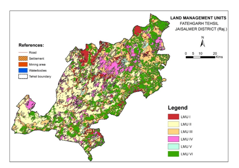 Fig. 1 Land management units of Fatehgarh tehsil soils
14.Land Resource Inventory of Churu district on 1:10000 Scale for Optimal Agricultural Land Use Planning using Geo-Spatial Techniques
Churu in Rajasthan is the most desiccated district of Indian arid zone. It, extending between 270 24‘ to 290 00′ N latitude and 730 40′ to 750 41’’E longitude with an area of 13592 km2, encompasses vast stretches of sandy flats and undulating sandy plains (dune height of 6 to 50 m) on an altitude of 213 to400 m above mean sea level. It experiences low, erratic and spotty rainfall, high temperature with large variations, annals of drought, high wind speed and low biological productivity. Agricultural intensification and massive infrastructure development in the recent years enhances the risk of soil erosion and fertility depletion. Climate is generally dry except during the monsoon period. Humidity is the highest in August with mean daily relative humidity of 80%. Mean annual rainfall of the district is 269.60 mm. Almost 95% of the total annual rainfall is received during the southwest monsoon, which enters the district in the last week of June and withdraws in the middle of September. The major part of the district is covered with extensive blanket of sand, through which low lying isolated hillrocks of hard rock occur. The sand dunes which are mostly of settled nature and interdunal hallows form undulating topography. Partially stabilized high dunes, partially stabilized medium dunes and sandy arid plain are identified as major landforms in Churu district which are divided based on the elevation. Landscape ecological units covering high dunes, medium dunes and arid plain have been developed. In the Churu district, 16 LEUs have been identified. Gently and very gently sloping dunes is under agriculture.
Hilly portion both in eastern Rajasthan upland and Vindhyan region are mainly severely eroded associated with rock outcrops and constitutes mainly forest area in the district.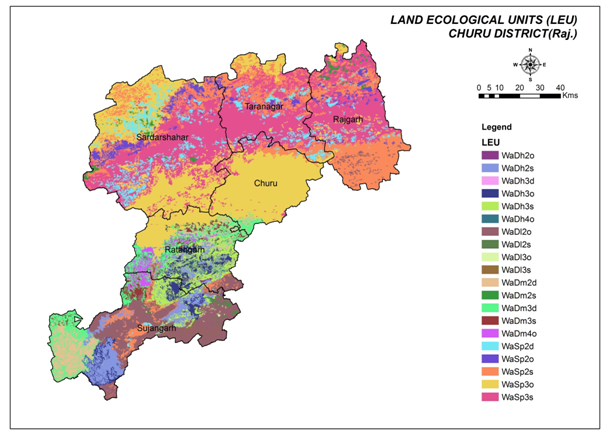 Fig. 2 Landscape ecological units map of Churu district
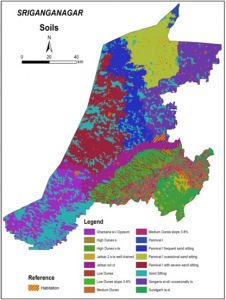
15.Land Resource inventory of Sriganganagar district, Rajasthan at 1:10000 scale for optimal agricultural land use planning using geo-spatial technique
Suratgarh taluka is situated in the Sri Ganganagar district of Rajasthan and located between 28.903 to 29.686 ◦N latitudes and 73.441 to 74.218 ◦E longitudes. It covers an area of 282289 ha with 470 villages. It represents AER -2 and Agro-ecological subregion 2.1 (Hot moist semi-arid). Suratgarh taluka which is a part of the Great Indian Desert was a typical desert prior to the construction of the canal. The study area has broadly divided into two major physiographic units i.e., fluvial origin (Fl) and Aeolian origin (Ae) (Fig. 4). Further these two major physiographic units were subdivided into sixbroad landforms units viz. (a) older alluvial plain (b) sandy undulating Alluvial plain (c) Flood plain (d) flat inter dunal plain (e) sandy undulating inter dunal plain and (f) sand dunes. The ground truth was carried out for checking of physiographic units. The detailed soil survey was carried out (1:10,000 scale) and 282289 ha area was surveyed. Tentatively nine soil series were identified and mapped into 12 mapping unit at the level of phases of soil series.
Anupgarh Tehsil is the one of nine tehsil of Sriganganagar district of Rajasthan, India. Anupgarh tehsil with 1, 14,935 ha geographical area extends between 28042’35” to 29025’37 N latitudes and between 72039’38” to 73043’45” E longitudes. Geologically Anupgarh tehsil are classified as mainly fluvial and Aeolian origin. The area is covered with blown sand deposits and gypsum is the only major mineral occurring in the tehsil. It displays a general slope towards west with the gradient of about 4-5 metre per kilometer. The sand dunes are generally 4 to 5 metres high except in the south western part where they are more intensely developed, being sometimes 10 to 15 metres in height. Anupgarh tehsil has been divided into three major physiographic units and further these physiographic units were subdivided into six brod landform units viz 1.Fluvial Origin-Older alluvial plain (FLAP) a) Dunes isolated b) Sandy undulating alluvial plain. 2.Fluvial Origin-flood plain (FLFP) a) Isolated sand dunes. 3.Aeolian origin- Aeolian plain (AeEO) a) Flat interdunal plain b) Sandy undulating interdunal plain c) Sand dunes. The detailed soil survey was carried out (1:10,000 scale) and 114935 ha area was surveyed. Tentatively six soil series were identified and mapped into eight mapping units at the level of phases of soil series.
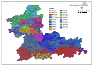
16.Land Resource Inventory of Hanumangarh district on 1:10000 Scale for Optimal Agricultural Land Use Planning using Geo-Spatial Techniques
Hanumangarh partly representing the command area of Thar desert ecosystem. These are situated between latitudes 28°45’35’’ and 29°57’25” N and longitudes 74°17’51” and 75°31’04”. Aeo-fluvial plains dominantly grown for cotton and wheat with support of canal irrigation affected with sand sheeting. Dunes, inter dunes and dune slopes are identified as major landforms in sandy arid plains which are divided based on the elevation. Ghaggar plains are another landform known for rice and cotton cultivation in desert ecosystem, affected with sand sheeting at places. Landscape Ecological unit map for Hanumangarh district based on the landforms, slope and land use linked with physiography and sub-physiography and legend of the map is described in Figure. Nine landscape ecological units in sandy arid plains (Wa) and seven units in semiarid transitional plain (Wb) are delineated. The soils of district are mapped into twenty two phases of ten series.
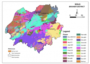
17.Land Resource Inventory of Bikaner district on 1:10000 Scale for Optimal Agricultural Land Use Planning using Geo-Spatial Techniques
Bikaner district is a part of Great Thar desert. These are situated between 27° 07’ to 29° 04’ North latitude and 71° 55’ to 74° 13’ East longitude, covering 29 lakhs ha area that comes to 7.9% of TGA of Rajasthan. The western, south-western, northern and northeastern parts of the district are largely covered with dunes of the different types and magnitudes with flat to undulating interdunal plains. The central eastern and southern parts of the district constitute largely flat and undulating plains. There are only a few small hill outcrops of about 1-2 m height near Kolayat in the district. Dunes, interdunes and sandy arid plain are identified as major landforms in Bikaner district which are divided based on the elevation. Landscape ecological units covering dunes, interdunes and sandy arid plain have been developed. In the Bikaner district, 10 LEUs have been identified. The soils of district are mapped into twenty one phases of twelve series.
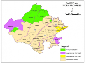
 18.Agricultural land use planning for Aspirational District
- Agricultural land use plan of Baran district of Rajasthan
Baran district is situated at the south-eastern corner of Rajasthan covering an area of 6, 992 km2 between 24°23’48” to 25°26’46”N latitude and 76°10’18” to 77°26’19”E longitude with total geographical area of 6, 992 km2. The district is a part of “Hadoti Region”, which has a distinct geomorphic region of Rajasthan state. Geomorphological features are alluvial plains, hills and plateau. These are segmented into the landforms. 74% area of the landforms is cultivated twice in the year, whereas another 24% area is defined under other land uses. Cropping intensity of the district is 158%. Major cropping systems are soybean/maize/ bajra/ jowar followed by wheat/ gram / mustard. 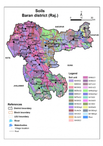
- Agricultural land use plan of Jaisalmer district of Rajasthan
Jaisalmer district lies in the western part of the Rajasthan between 26°4’44” to 28°14’32”N latitude and 69°33’2” to 72°14’4”E longitude and covers an area of 37, 064 km2. As the district lies in the western plain Marusthali, experiences extremes heat in summer and cold in the winter. The western plain Marusthali is further segmented into the broad landforms, which are further taken down to the landscape ecological units. Agriculture is depended on good rains, otherwise stretch of the land remained uncultivated. The district is a part of the ‘Great Thar Desert’. The terrain is undulating with sand dunes, at some places stony, rocky and barren. Wind erosion is the dominant degradation process and the spatially affected area by erosion. In the district, 86.7% of the population belongs to the rural areas. 14.8 and 6.3% population belongs to SC and ST respectively. 45.9% were cultivators and 19.2% were agricultural labourers.
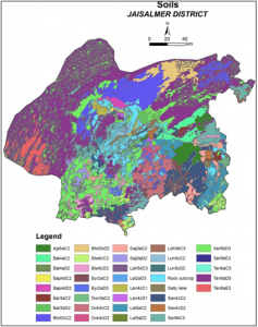
Fig. 7 Soil map of Jaisalmer district
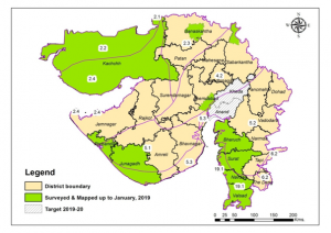
Blocks / Talukas / Mandal surveyed under Land Resource Inventory, Rajasthan
| S No | Region | Block/Mandal | District | Area (ha) | Comment |
| 1. | Hanumangarh | Hanumangarh | 122015 | Survey completed | |
| 2. | Sangaria | Hanumangarh | 65279 | Survey completed | |
| 3. | Rawatsar | Hanumangarh | 187620 | Survey completed | |
| 4. | Nohar | Hanumangarh | 246265 | Survey completed | |
| 5. | Bhadara | Hanumangarh | 173095 | Survey completed | |
| 6. | Tibbi | Hanumangarh | 74316 | Survey completed | |
| 7. | Pilibanga | Hanumangarh | 101136 | Survey completed | |
| 8. | Anupgarh | Sri Ganganagar | 75493 | Survey completed | |
| 9. | Gharsana | Sri Ganganagar | 138249 | Survey completed | |
| 10. | Karanpur | Sri Ganganagar | 81887 | Survey completed | |
| 11. | Padampur | Sri Ganganagar | 84287 | Survey completed | |
| 12. | Raisinghnagar | Sri Ganganagar | 131586 | Survey completed | |
| 13. | Sadulsahar | Sri Ganganagar | 77031 | Survey completed | |
| 14. | Suratgarh | Sri Ganganagar | 242366 | Survey completed | |
| 15. | Sriganganagar | Sri Ganganagar | 98638 | Ongoing | |
| 16. | Vijaynagar | Sri Ganganagar | 82951 | Ongoing | |
| 17. | Churu | Churu | 161080 | Survey completed | |
| 18. | Rajgarh | Churu | 221258 | Survey completed | |
| 19. | Ratangarh | Churu | 169791 | Survey completed | |
| 20. | Sardarsahar | Churu | 383946 | Survey completed | |
| 21. | Sujangarh | Churu | 270035 | Survey completed | |
| 22. | Taranagar | Churu | 180695 | Survey completed | |
| 23. | Bikaner | Bikaner | 370180 | Survey completed | |
| 24. | Khajuwala | Bikaner | 203702 | Survey completed | |
| 25. | Pugal | Bikaner | 231147 | Survey completed | |
| 26. | Lunkaransar | Bikaner | 509434 | Survey completed | |
| 27. | Sridungargarh | Bikaner | 298571 | Survey completed | |
| 28. | Kolayat | Bikaner | 829275 | Survey completed | |
| 29. | Chattergarh | Bikaner | 204218 | Survey completed | |
| 30. | Nokha | Bikaner | 379799 | Survey completed | |
| 31. | Fatehgarh | Jaisalmer | 438400 | Survey completed | |
| 32. | Pokharan | Jaisalmer | 948207 | Ongoing | |
| 33. | Jaisalmer | Jaisalmer | 2388001 | Ongoing | |
| 34. | Neem Ka Thana | Sikar | 118200 | Survey completed |
GUJARAT
1.Soil resource mapping of Gujarat state on 1:250,000 scale.
The state of Gujarat covers an area of 19.6 m ha and account for six percent of the total geographical area (TGA) of the country. The state is endowed with wide variations in climate, geology, landforms and vegetation which are reflected in the development of a large variety of soils. The soil mapping units, including rock outcrops, cover 86.4 percent and the Rann of Kachchh covers another 11.0 percent of the TGA. The soils belong to 5 Orders, 11 Suborders, 20 Greatgroups, 45 Subgroups, 124 Families and 145 soil series. The Inceptisols are dominantly observed covering 51 percent, followed by Entisols, Aridisols, Vertisols covering 13.8, 10.6 and 8.9 percent of TGA, respectively; the Alfisols are least represented covering 0.6 percent area. The rock outcrops constitute 1.8 percent of the TGA.
In order to cater the needs of various user agencies, thematic maps, such as soil depth, texture, drainage, available water capacity, erosion, calcareousness, pH, salinity, sodicity, etc. have been generated using the master soil resource map and the survey database. In order to ameliorate the problematic soils, an assessment of degradation of soils has been made. The data show that 8.1 m ha, representing 41.5 percent of TGA in Gujarat, is affected by various soil degradation problems included mainly by human- intervention. The most serious problem is of water erosion, causing loss of top soil and/or terrain deformation, and has affected 5.2 m ha representing 2.3 percent of the TGA. Salinity alone and in combination with water/wind erosion and flooding has been found to affect 2.5 m ha representing 12.7 percent area. The area not fit for agriculture, including rock outcrops and Rann/salt flat, accounts for 1.8 and 11.0 percent of the TGA, respectively.
2.Land Resource Inventory (1:10000 scale) for Gujarat State: a step towards enhancing agricultural productivity.
The preparation of the land resource inventory on 1:10,000 scale for six talukas were undertaken with the objectives to develop land resource inventory on 1:10000 scale for the arable land of Gujarat using geo-spatial techniques, to identify constraints affecting land utilization and crop production at village level and to evaluate the available land resources for existing, promising and alternate land uses for enabling agricultural land use planning. Talukas were selected considering the priority of the state departments, agro-climatic/AESR conditions and variability in land use. Physiographic land units (PLU) were delineated by disaggregating of complex soil map unit (soil legacy data) by redrawing/redrafting boundaries in conjunction with geomoropholy, slope-DEM, temporal LULC and keeping primary layers (cadastral, taluka, district, geology, landform/physiography maps) in the back ground. Scheme of the PLU map is shown in the table 3. Soil legacy data codes were shown on the working base map for the bravety. Soil and mapping were completed for 7918 sq km area in Ankleshwar, Dholka, Porbandar, Rapar, Deesa and Khedbrahma takulas following the standard methodology. Soils have been mapped at phase of series.
The detailed soil survey have been carried out of Rapar Taluka, Kachchha district covering an area of about 2.95 lakh hac representing different agro-ecological sub-regions in the Gujarat state for detailed land resource inventory and agricultural land use planning. Using available soil resource information of State on 1.250,000 scale soil resource map and remote sensing data of high spatial resolution IRS P6-LISS-IV data (5.8 m) and Cartosat-1 panchromatic data (2.5 m) for quick and precise land resource inventory on 1: 10,000 scale. Soil maps of Rapar have been finalized. Four major landforms viz. viz. Hills and pediment, Arid plain, Mud flats and Coastal plain. Nineteen soil series have been identified and mapped into 32 mapping units in Rapar taluka. Soil physical and chemical properties of all three talukas, Deesa, Banaskantha district, Porbandar taluka, Porbandar district and Rapar taluka, Kachchha district (Gujarat) has been completed. Eight land management units (LMU) have been generated by the spatial integration of land units (sixteen soil mapping units), present land use, agro-ecology and farming/production system in Deesa taluka, Banaskantha district. The soils of each land management units has been evaluated for suitability for major Kharif and rabi crops by matching soil site characteristics of sixteen soil mapping units with crop requirements.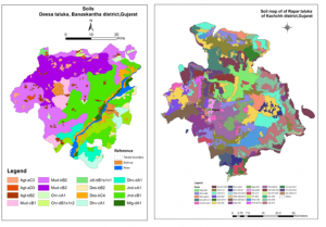 Fig. 8 (a) Soil map of Deesa and Raper talukas of Gujarat
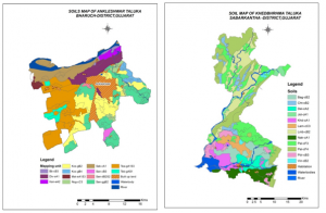 Fig. 8(b) Soil map of Ankleshwer and Khedbhrama talukas of Gujarat
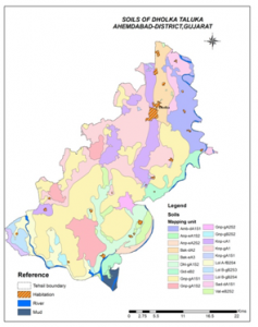
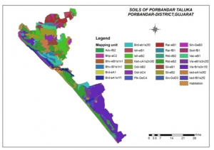 Fig. 8(c) Soil map of Dholka and Porbander talukas of Gujarat
3.Land resource inventory of Netrang Taluka, Bharuch district, Ranavav and Kutiyana talukas, Porbandar district, Gujarat on 1:10000 scale for optimal agricultural land use planning, using geo-spatial techniques
Two major landforms viz. Hills and Plateau have been delineated in Bharuch taluka.Four major landforms viz. Hills, pediments, pediplane and coastal plain have been delineated in Ranavav and Kutiyana taluka probandar district.Soil maps of all the three talukas has been finalized. Fifteen soil series have been identified which mapped into 16 mapping units in Netrang taluka Soils of Netrang taluka have major problems like shallow soil depth, erosion, slope and stoniness,whereas in Ranavav taluka 12 series mapped into sixteen mapping units and Kutiyana talukas eleven series mapped into fourteen mapping units. Major constraints identified in the area are soil depth, erosion, stoniness, flooding and salinity-sodicity in Ranavav and Kutiyan taluka, Porbandar district.
Major soils identified in Ntrang talukas in hills are very shallow-to-shallow, loamy/clayey skeletal, Lithic Ustorthents followed by moderately shallow, fine, Typic Ustorthents. They are severely to very severely eroded, strongly to very strongly strongly stonininess, severely to very severely eroded, moderate to steep slopes and mostly under forest or pasture lands. Soils on plateau undulating dissected plateau are moderately shallow, fine loamy to fine, Typic Haplustepts.They are under scrubs and under sorghum or pigeon pea cultivation. Soils on gently sloping plateau are moderately shallow to moderately deep, fine and fine loamy, Vertic Haplustepsts/ Typic Haplustepts. These soils are cultivated to pigeon pea, sorghum, cotton and sem. Soils on very gently sloping plateau are deep, fine Typic Haplusterts and fine to fine loamy,Typic Haplusterts. They cultivated to pigeon pea, cotton, sugarcane and at places wheat, banana, and papaya orchards.
Major soils identified in Ranavav and Kutiyana talukas in hilly and pediments are very shallow to shallow, loamy skeletal, Lithic Ustorthents and on pediplane are moderately shallow to moderately deep Typic Haplustepts followed by Vertic Haplustepts & Typic Haplusterts. Soils on coastal plains are poorly drained and moderately deep and deep, fine and slightly to moderately flooded, slightly to strongly saline and sodic problems and are classified as fine Typic Haplusterts and Typic Halaquepts. For the brevity of space land ecological unit (LEU) and soil map of Netrang taluka, Bharuch dictrict has been presented.
4.Land resource inventory of Bharuch taluka, Bharuch district, Gujarat on 1:10000 scale using geo-spatial techniques for optimal agricultural land use planning.
Three soil series namely Umraj, Derol and Singdot have been identified and classified in Vertisols and Inceptisols soil orders and covering 48.5% and 39.1% areas of the taluka. Umraj, Derol and Singdot were classified as very-fine, smectitic, hyperthermic Typic Haplusterts; fine, mixed, hyperthermic Vertic Haplustepts and fine-loamy, mixed, hyperthermic Typic Haplustepts, respectively.Soils are very deep, well to moderately well drained with clayey surface texture in 48.5% area followed by silty clay (32.5% area) and clay loam (6.6% area). The analysis of soil physical properties indicated that the clay content of surface soil ranged from 30.4 to 64.2% with textural classes of clay to clay loam. In soil series control section, its value ranged from 23.3 to 67.2%. Chemical properties of surface soils showed that pH ranged from 7.3 to 8.3, EC- 0.15 to 1.07 dS m-1, OC- 0.35 to 0.58%, CEC- 39.4 to 57.9 cmol (p+) kg-1) and base saturation- 67.4 to 89.4%. In soil series control section, pH varied from 7.6 to 8.4, EC- 0.10 to 0.92 dS m-1, OC- 0.14-0.43%, CEC- 40.2 to 62.0 cmol (p+) kg-1 and base saturation- 76 to 92%. The soils were derived from basaltic alluvial parent material of Amarkantak plateau and earlier deposits, which are present in substratum, influenced their properties. Soil suitability evaluation revealed that about 81.0% and 6.6% of TGA of the taluka is highly suitable (S1) and moderately (S2) suitable for cotton cultivation. About 81.0% area is moderately suitable (S2) and 6.6% area is highly suitable for pigeon pea, maize, sugarcane and chickpea cultivation. The soils of the taluka are moderately suitable (S2) for wheat cultivation.
5.Land resource inventory of Kamrej taluka, Surat district, Gujarat on 1:10000 scale using geo-spatial techniques for optimal agricultural land use planning.
Soil resource mapping of the taluka is carried out on 1:10,000 scale using IRS P6 LISS IV satellite data. Three soil series namely Abrama, Digas and Sampura have been identified. Soils are classified in Vertisols and Inceptisols soil orders and covering 55.7% and 31.0% areas of the taluka. Abrama, Digas and Sampura were classified as fine, smectitic, hyperthermic Typic Haplusterts; fine, mixed, hyperthermic Vertic Haplustepts and fine-loamy, mixed, hyperthermic Typic Haplustepts, respectively. Soils are very deep, well to moderately well drain with clayey surface texture in 75.4% area followed by clay loam (11.3% area). The analysis of soil physical properties indicated that the clay content of surface soil ranged from 37.4 to 52.8 per cent with textural classes of clay to clay loam. In soil series control section, its value ranged from 24.8 to 61.1 per cent with textural classes of clay to sandy clay loam. Chemical properties of surface soils showed that pH ranged from 7.4 to 8.4, EC- 0.15 to 0.31 dS m-1, OC- 0.42 to 0.66%, CEC- 44.4 to 57.0 cmol (p+) kg-1) and base saturation- 82.1 to 89.2%. In soil series control section, pH varied from 7.4 to 8.5, EC- 0.16 to 0.29 dS m-1, OC- 0.15-0.43%, CEC- 40.2 to 63.6 cmol (p+) kg-1 and base saturation- 75 to 98%. The soils were derived from basaltic alluvial parent material and their properties were also influenced by earlier deposits which are present in substratum. Soils of block has moderate productivity potential. Soil suitability evaluation revealed that about 31.0% and 55.7% of TGA of the taluka is highly suitable (S1) and moderately (S2) suitable for sugarcane cultivation. About 26.4% area of taluka is highly suitable (S1), 49.0% area is moderately suitable (S2) and 11.3% area is marginally suitable (S3) for rice cultivation. About 75.4% area of the taluka is moderately suitable and 11.3% area is highly suitable for wheat and banana cultivation. The soils of the taluka are moderately suitable (31.0% area) to marginally suitable (55.7% area) for mango plantation.
6.LRI of Bhuj and Mundra taluka, Dist. Kutch, Gujarat on 1:10,000 scale using geo-spatial techniques for optimal agricultural land use planning.
A detailed soil survey was undertaken at 1:10000 scale in Bhuj and Mundra taluka, Kutch district, Gujarat. Ten soil series were identified in Bhuj taluka viz. Gajod, Naranpar, Chundi, Meghpar, Barasan, Kali talvadi, Loria, Bhirandiara, Dhrobana and Dinara. Similarly, four soil series namely Ratadiya, Baraya, Beraja and Tapper were identified in Mundra taluka. Soil depth varied from 08 cm (Naranpar series) to 150 cm (Kali talvadi, Loria and Bhirandiara series) and soil texture varied from sandy loam to sandy clay loam at surface and in soil series control section. The soils were slightly alkaline to moderately alkaline (7.6-8.8) in nature (Fig. 1). The organic carbon (OC) content was low to moderate in the surface layers (0.16-0.67%) and decreased in subsurface horizons (0.04-0.52%) except Meghpar soils have very high OC content (1.47%) in surface layer. The clay content (%) varied from 10.8 to 30.0 in surface horizons and from 10.4 to 33.0% in subsurface horizons. The irregular trend of clay content was found in soils with depth. The CaCO3 content was low to high and ranged from 1.2-44.3% in the control section of the soils. The higher CaCO3 content may be due to the formation of pedogenic carbonate facilitated by the semi-arid climate and calcium rich parent material.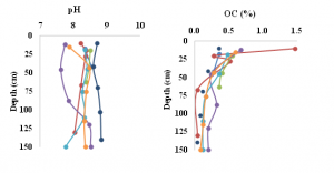
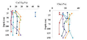
![]() Fig. 9 Depth-wise distribution of some soil properties in Bhuj taluka, Kutch district
Fig. 9 Depth-wise distribution of some soil properties in Bhuj taluka, Kutch district
7.LRI of Keshod and Vanthali taluka, Dist. Junagadh, Gujarat on 1:10,000 scale using geo-spatial techniques for optimal agricultural land use planning.
On the basis of morphological, physical and chemical characterization three soil series identified in Keshod taluka viz. Ajab, Bamnasa and Khirsara. Similarly, three soil series namely Aakha, Khokharda and Bodka were identified in Vanthali taluka. Soil depth varied from 120 cm (Ajab series) to 150 cm (Khirsara and Bamnasa series). Soil texture varied from loam to sandy clay at surface and clay to sandy clay in soil series control section. The OC content varied from 0.91 to 1.43% in the surface layer and 0.42-0.99% in subsurface layer. Percentage clay varied from 24.4 to 44.4 in the soil series control section. CEC varied from 13.9 to 43.0 [cmol p (+) kg-1] in the soil series control section. Calcium carbonate content ranged from 7.3-32.4% and generally showed increasing trend with depth.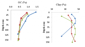
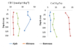 Fig. 10 Depth-wise distribution of some soil properties in Keshod and Vanthali taluka
Blocks / Talukas / Mandal surveyed under Land Resource Inventory in Gujarat
| S No | Region | Block/Mandal | District | Comment |
| 1. | Western | Ankaleswar | Bharuch | Survey completed |
| 2. | Dholka | Ahmedabad | Survey completed | |
| 3. | Khedbrahma | Sabarkantha | Survey completed | |
| 4. | Deesa | Banaskantha | Survey completed | |
| 5. | Porbandar | Porbandar | Survey completed | |
| 6. | Rapar | Kutch | Survey completed | |
| 7. | Nakhtrana | Kutch | Survey completed | |
| 8. | Lakhpat | Kutch | Survey completed | |
| 9. | Gandhidham | Kutch | Survey completed | |
| 10. | Mandvi | Kutch | Survey completed | |
| 11. | Abdasa | Kutch | Survey completed | |
| 12. | Bhuj | Kutch | Survey completed | |
| 13. | Mundra | Kutch | Survey completed | |
| 14. | Anjar | Kutch | Survey completed | |
| 15. | Bhachau | Kutch | Survey completed | |
| 16. | Jhadadia | Bharuch | Survey completed | |
| 17. | Amod | Bharuch | Survey completed | |
| 18. | Vagva | Bharuch | Survey completed | |
| 19. | Jamusar | Bharuch | Survey completed | |
| 20. | Valia | Bharuch | Survey completed | |
| 21. | Bharuch | Bharuch | Survey completed | |
| 22. | Hansat | Bharuch | Survey completed | |
| 23. | Netrang | Bharuch | Survey completed | |
| 24. | Valia | Bharuch | Survey completed | |
| 25. | Vagra | Bharuch | Survey completed | |
| 26. | Mandvi | Surat | Survey completed | |
| 27. | Mangrol | Surat | Survey completed | |
| 28. | Umarpada | Surat | Survey completed | |
| 29. | Olpad | Surat | Report submitted | |
| 30. | Kamrej | Surat | Survey completed | |
| 31. | Palsana | Surat | Survey completed | |
| 32. | Bardoli | Surat | Survey completed | |
| 33. | Surat City | Surat | Survey completed | |
| 34. | Chorasi | Surat | Survey completed | |
| 35. | Mahuva | Surat | Survey completed | |
| 36. | Dharampur | Valsad | Survey completed | |
| 37. | Valsad | Valsad | Report submitted | |
| 38. | Pardi | Valsad | Report submitted | |
| 39. | Vapi | Valsad | Survey completed | |
| 40. | Umargaon | Valsad | Survey completed | |
| 41. | Kaparda | Valsad | Survey completed | |
| 42. | Gandevi | Navsari | Survey completed | |
| 43. | Chikhil | Navsari | Survey completed | |
| 44. | Jalalpur | Navsari | Survey completed | |
| 45. | Navsari | Navsari | Survey completed | |
| 46. | Bansda | Navsari | Survey completed | |
| 47. | Khergaon | Navsari | Survey completed | |
| 48. | Mangrol | Junagadh | Survey completed | |
| 49. | Manavadar | Junagadh | Survey completed | |
| 50. | Keshod | Junagadh | Survey completed | |
| 51. | Vanthali | Junagadh | Survey completed | |
| 52. | Maliya | Junagadh | Survey completed | |
| 53. | Menderda | Junagadh | Survey completed |
Externally Funded Projects (National)
1.Reflectance Libraries for development of soil sensors for the assessment of the state of soil resources
Reflectance at different wavelengths were recorded at four sites each in the state of Gujarat (Manasa-Vijapur and Bhuj area) and Rajasthan (Gogunda- Udaipur area) have been selected for study of reflectance characteristics in relation to surface features and soil properties. Majorlandforms/physiography have been delineated on the basis of image attributes like shape, pattern and colour with reference to the SOI toposheet, existing land use., variation in soil characteristics. High reflectance value have been recorded for bare rocks, gravelly soils, dry soils, sandy soils, saline soils, eroded soils and red soils in the visible range. Rocky/gravelly surfaces reflect more incident radiation as compared to other soil surfaces. Fine texture soil surfaces reflect light at lower intensity as compared to coarse texture soils. Reflectance of incident radiant energy is lower in moist soils as compared to dry soils. Smooth surfaces reflect more incident light than rough surface. Salt encrustation tends to make the incident light to reflect with higher intensity. Similarly red coloured soils in 5YR hue also give higher reflectance. Muddy water reflects more light as compared to clear water.Salt encrustation and soil erosion tend to give brighter image characteristics as compared to normal surfaces. Water logging tends to give a darker colour as compared to normal surfaces. Rocky surfaces also give darker colour to the image but are differentiated from other dark colour image features.
2.Identification, characterization and delineation of Agro-economic constraints of oilseed based production system in rain fed ecosystem.
In order to identify constraints in production of oilseed crops, mustard and groundnut Bharatpur in Rajasthan and Rajkot and Junagadh in Gujarat were selected. 144 farmers representing marginal, small and large holdings were selected in major oilseeds producing tehsils in the district. Socio-economic survey was undertaken for mustard in Bharatpur Rajasthan and Groundnut in Rajkot and Junagarh district in Gujarat.
3.Integrated National Agricultural Resources Information System-Soil Resource data base
Attributes of 375 mapping units delineated in soil resource map of Rajasthan on 1:250,000 scale have been entered in MS Access programme. This information is being utilized to prepare digitized soil map of Rajasthan and thematic maps. Information is being proposed to be made available to the users through the website of the Institute on soils of Rajasthan.
4.Land Use Planning for management of Agricultural Resources in Arid Eco-System
Resource characterization and constraint analysis of productivity in land use planning of micro-watershed Changeri district Udaipur.
Detailed soil survey of the watershed was completed on cadastral map of 1:4000. Soil map was digitized using GIS, Geomedia and thematic maps for various soil parameters have been prepared. Watershed has been delineated in six soil units depicting variation of depth, texture and CaCO3. Soil depth is between 40-50 cm in 45.6% area, 65-75 cm in 22.2%, 90 cm in 5.4% area and >100 cm in 26.7% area. Distribution of soil characteristics with respect to pH, EC, O.C., CaCO3 and available micronutrients has been determined from thematic maps.
Suitability for 9 crops under rainfed condition and 5 crops under irrigated condition have been evaluated by matching soil site characteristics with crop requirements. Soil depth is major limiting factor in 35.6% area whereas high pH and ESP are major limiting factor for crops in 26.7% area. 27.6% soil are generally suitable to moderately suitable during Kharif and suitable for rabi crops under irrigation and 72.3 % soils moderate to marginally suitable for different crops.
The ground water indicated slight increase in pH towards the end of rabi season in February – March and a decline during rainy season with fresh recharge of ground water. During irrigation season from Oct.2002 to Jan.2003 there has been average increase in pH by 0.5 almost in all the wells. E.C. of ground water during September 2002 varied between 0.4 – 0.8 dSm-1 in wells around pond and between 1.0- 1.5 dSm-1 in wells at distance from pond.
Wheat yield was about 49.6 – 51.3 Q/ha with 6 irrigation in shallow soils and 5 irrigations in moderately deep to deep soils. Yield reduction in moderately deep soils was almost 40% with 3 irrigation as compared to 5 irrigations. Increase in fertilizer levels from N80 P40 to N120 P60 increased wheat yield by 3.5 to 4.4 Q/ha. One additional irrigation in shallow soils compensated the limiting effect of soil depth and yield level can be achieved as that of moderately deep and deep soils. Under rainfed condition average yield of maize in shallow soils (< 50 cm) was only 3.1 to 11.0 q/ha which increased to 12.5-20.3 q/ha in moderately deep to deep soils. Two supplemental irrigations have increased the yield to 24.6-34.1 q/ha where as one irrigation gave 21.5 q/ha yield. Under rainfed condition groundnut yield was 3.7-5.6q/ha in shallow soils (< 50 cm) which increased to 11.6q/ha in moderately deep to deep soils. One supplemental irrigation resulted in significantly higher yield (18.2q/ha).
Consultancy Projects
5.Soil resource mapping of rubber growing areas of Kerela and Tamil Nadu on 1:50,000 scale (World Bank) through Rubber Board of India
Soil survey and mapping of rubber growing areas of Kerala and Tamil Nadu have been carried out on 1:50,000 scale to characterize, classify and map the soils, identify the problems and potentials of the area and prepare soil fertility maps to facilitate efficient fertilizer recommendation.
Geological forms (Khondalitic and laterite), mounds and hills predominantly affect soil characteristics. Soils developed on mounds are generally deep, sandy clay loam to clay, yellowish brown to red with low base saturation. Soils developed on hills are moderately deep, sandy caly to clay, strong brown to reddish brown with high base saturation. Soils developed on lateritic landscape are deep, sandy clay loam in with 25 – 43 % base saturation. Soils on Khondalite landform are moderately deep to deep, sandy clay loam to clay and high base saturation. Organic carbon, available P and K in soils developed on Laleritic landform are lower as compared to soils developed on Khonalites. Available Ca and Mg is higher in soils developed on Latritic land scape as compared to those developed on Khondalites. Soils developed on mound upland are suitable for rubber cultivation whereas soils developed on summit side slopes and hills are moderate to marginally suitable.
Concentration of P, K, Ca, Mg, Cu and Fe in rubber plantation of 10-15 years is generally higher as compared to younger as well as old planation. Concentration Mn and Zn are higher in younger plantation upto 10 years and decreases afterwards. Content of P, K, Ca and Mn in rubber plants in Lateritic landform is generally lower as compared to rubber grown on Khondalitic land form. Available Mg and available Fe is higher in lateritic landform as compared to Khondalitic landform. There is no significant difference with respect to available Cu and Zn.
6.Mapping and Assessment of Land Degradation in major Ecosystems of India Using Geospatial Technologies (ICAR Extramural Project)
- Denudational ridges/ Denudational foot slopes: Such areas are scattered from Northern to Central and Southern part of the Tehsil. Most ridges have steep slopes. Soil cover is practically non-existent over the ridges whereas foot slopes is made up of shallow (10-15 cm) soils where it has sand to loamy sand texture. This class is severely eroded by wind. This class has the potential for runoff generation and utilization in the vicinity. The main vegetation of this area is Capparis deciduas, Zizyphus nummularia.
- Interdunal pediments: This unit is mostly occurs between the stabilized longitudinal sand dunes. The land is mainly used as open grazing area causing vegetation degradation by sheep and goats. This unit provides suitable sites for collecting surface runoff in tanks and reservoirs.
- Aeolian Pediment: These plains are severely eroded by sheet erosion and slight to moderate gully erosion by water. Soil surface is sometime exposed or very little soil cover is found. The land is mainly used as open grazing area causing vegetation degradation by sheep and goats.
- Longitudinal sand dunes: Longitudinal sand-dunes are the most spectacular landforms of the Fatehgarh Tehsil covering large in the west. A major part of this class comprises of stable sand dunes and few mobile/ active sand dunes. Deep and fine sand throughout the profile. Severe wind erosion is found in this unit.
- Interdunal Plains: This unit is mostly occurs between the stabilized longitudinal sand dunes. Intense Aeolian activities have created undulations on the alluvial surfaces of this unit in the form of sand sheets. This unit is affected by severe wind erosion or dune mobility. The interdunal plains are mostly cultivated as rainfed single/ or irrigated double cropping causing land degradation through nutrient mining and/ or development of soil salinity.
- Aeolian Plains: Soils are moderately deep to deep, fine sand to loamy sand at the surface and loamy sand to sandy loam in the subsoil underlain by lime concretionary zone. These plains are severely affected by wind erosion and slight to moderate water erosion hazards. These plains are mostly cultivated as rainfed single/ or irrigated double cropping system causing land degradation through nutrient mining and/ or development of soil salinity.
- Mining Area: Land degradation through mining the surface area and other area by deposits of mining waste.
The different soil degradation processes are operating in different landforms at various intensity and areas of operation. In all, 8 degradation processes with their striking area is calculated as per followings.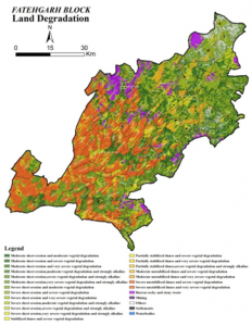
Fig. 11 Soil degradation map of Fatehgarh tehsil of Jaisalmer district
Table: Fatehgarh tehsil land degradation statistics.
| Sr No | Soil degradation process | Striking Area (ha) |
| 1. | Edp2 | 29 635.7 |
| 2. | Eds1 | 1748.9 |
| 3. | Edu1 | 1649.5 |
| 4. | Edu2 | 11555.1 |
| 5. | Edu3 | 109792.4 |
| 6. | Esh1 | 38333.7 |
| 7. | Esh2 | 97918.0 |
| 8. | Esh3 | 128988.8 |
7.Improving livelihood through integrated natural resource management in Chanawada watershed, Girwa tehsil, Udaipur district (under Tribal sub plan)
- Hybrid Maize Production Helps Uplift Chanaveda Tribal Farmers
Improved agriculture can provide the opportunity to tribal’s to improve their livelihood. The maize-wheat cropping system is dominant in the Chanaveda tribal belt. The cropping intensity varies between 140% in a good monsoon to year to 110% in a meager rainfall year. Maize, sorghum, rice, cluster bean, sesame and pulses are main kharif crops. Wheat, mustard and chickpea are the major rabi crops. Growing of suitable hybrid was considered better agronomic option under the terrain and undulating topography of the Chanavda village. White desi maize has long been the staple of the Mewar tribals. They find it tastier. “But it is true that rotis made of yellow maize are sweeter and yields are higher.” says Gautum Meena of DangFala of Chanaveda Panchayat.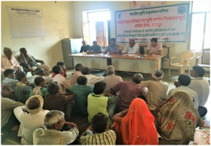 Fig. 12. Training session on improved maize production
Shifting tribal farmers from low-yield, low-income maize to more productive agriculture through Hybrid Maize production programme of ICAR-NBSS&LUP, Udaipur has been at the centre of tribal uplift in Chanaveda tribal belt. The novelty is in its application in shallow to moderately deep, well drained, gravelly loamy soils and poorly-irrigated hilly tribal areas where farms are stamp-sized. They are provided with 5.0 kg Maize hybrid DHM-117 (Medium, orange-yellow, flint, Nutrient responsive, tolerance to lodging & stay green, average yield 75q/ha) OR PEHM-2 (An early maturing hybrid, suitable for normal sowing, tolerant to water logging) along with 15 kg DAP and 25 kg neem coated urea. About 200 farmers were selected for improved maize cultivation. Maize hybrid DHM-117 recorded higher values of yield attributes. Use of Hybrid Maize and application of fertilizer through neem coated urea and di-ammonium phosphate has resulted in 55 to 137.0% higher grain yield than Local variety. This has caused net return in the range of Rs 72, 000/- to 78, 000/- per hectare and benefit-cost ratio of 2.97 to 3.13.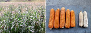
Fig. 13 Performance of maize hybrid DHM-117 Fig. 14 Maize DHM-117 and Local variety cob
- Improved Wheat production technology
Wheat improved production technology is demonstrated at about 200 farmer’s field. Crop data analysis is on progress. About 150 farmers having irrigation facilities were selected. Selected farmers were given training for improved package of practices of wheat. Improved variety of wheat Raj-4238 is suitable for Irrigated condition, late sowing, 110-115 day duration, yield potential 4.7 tonnes ha-1. Farmers were provided with20 kg seed, 15 kg DAP, 25kg NCU and 50ml chloropyrophous was provided to each farmer. Improvement of 12-20% in wheat yield over control was recorded.
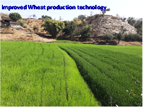 Fig. 14 Impact of improved wheat production technology
- Distribution of Grain Storage bins
Reducing Postharvest Losses during Storage of Grain Crops to Strengthen Food Security. Technology interventions and improved storage structures can significantly reduce store losses. However, it is important to understand that training of smallholders is equally as necessary as the technology dissemination. Storage plays a vital role in the food supply chain. More than one-third of food is lost or wasted in postharvest operations. Reducing the postharvest losses was thought to be a sustainable solution to increase food availability, reduce pressure on natural resources, eliminate hunger and improve farmers’ livelihoods.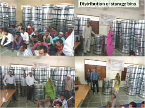 Fig. 15 Distribution of grain storage bin to tribal farmer in Chanaveda village, Girwa, Udaipur
Potential area identification of major crops in Gujarat
Soil and site suitability was evaluated for rice, wheat, cotton, sugarcane crops in 14 map unit of 11 soil series in Ankleshwar taluka, wheat groundnut, cotton, rice, pigeon pea in 12 map unit of 10 soil series in Khedbramaha taluka whereas pearl millet, cotton, wheat and rice in 19 map unit of 10 soil series in Dholka taluka. Soil and site suitability evaluation are further applied for pearl millet, guar, moong, cotton in 30 map unit of 18 soil series in Rapar taluka and groundnut, coriander, cumin, sorghum and chickpea in 28 map unit of 16 soil series in Porbandar taluka.
Institute funded project
- High resolution soil mapping using digital soil mapping techniques in Central Region of Gujarat
- Land Resource Inventory of Anand District, Gujarat Using the New SOP for Optimal Agricultural Land Use Planning
- Land Resource Inventory of Tapi District, Gujarat Using the New SOP for Optimal Agricultural Land Use Planning.
- Land Resource Inventory of Vadodara District, Gujarat Using the New SOP for Optimal Agricultural Land Use Planning
- Land Resource Inventory of Dangs District, Gujarat Using the New SOP for Optimal Agricultural Land Use Planning
- Land resource inventory (1:10000 scale) of Dahod district, Gujarat for optimal agricultural land use planning using geospatial techniques.
- Land resource inventory (1:10000 scale) of Narmada district, Gujarat for optimal agricultural land use planning using geospatial techniques.
- Land resource inventory (1:10000 scale) of Amreli district, Gujarat using the new SOP for optimal agricultural land use planning.
- Land Resource Inventory of Sri Ganganagar district (Rajasthan) on 1:10000 scale for optimal agricultural land use planning using geo-spatial techniques.
- Assessment of Ecosystem Service Value in Response to LULC Changes in different agro-climatic zones of Rajasthan Using Geospatial Techniques.
- Land resource inventory of Morena district, Madhya Pradesh on 1:10000 scale for optimal agricultural land use planning, using geo-spatial techniques.
- Land Resource inventory of Pokharan and Jaisalmer tehsil of Jaisalmer district, Rajasthan at 1:10000 scale for optimal agricultural land use planning using geo-spatial technique.
- High resolution soil mapping of Barmer district, Rajasthan for optimal agricultural land use planning using digital soil mapping techniques
- Livelihood improvement of SC community through the integrated approaches of natural resource management in South-eastern region of Rajasthan (SCSP).
Externally funded project